
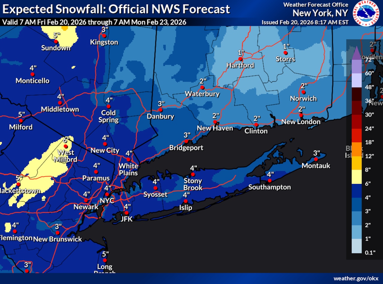
STATEN ISLAND, N.Y. — Although uncertainty remains, meteorologists are beginning to gain a picture of the kind of impact the weekend nor’easter will have on New York City.
“There’s high confidence in there being a strong, offshore low pressure system, but there’s still a little bit of a question on how close that’s going to track to our area,” James Tomasini, a meteorologist with the National Weather Service, said.
As of Friday morning, Tomasini foresees snowfall around 4 inches. On the high end, there is a one in 10 chance of accumulation amounts reaching up to 10 inches. However, if the storm tracks further off the coast, the city may only receive a trace of snow.
Bill Deger, a senior meteorologist with AccuWeather, believes snow will begin to fall on the five boroughs Sunday morning before ramping up in the evening hours and lingering into Monday morning.
A “good bet” would be for the city to receive a general 1-3 inches of accumulation; 3-6 inches is a possibility for those in eastern Long Island, according to Deger.
However, both meteorologists explained that these snowfall amounts are subject to change and are dependent on the ultimate track of the coastal storm.
“There is not only the area of low pressure that will be off to our south and east, but there’s kind of a component in the upper level in the atmosphere but coming in from the west that could act to kick this storm further east quicker and if that happens, yeah, we’ll probably end up on the lower range of our 1-3 inch forecast,” Deger told the Advance/SILive.com.
On the flip side, if the storm were to track closer to the coast, city residents could be dealing with some significant snowfall.
In addition to the track of the storm, the surface temperatures will play a role in determining final snowfall accumulation amounts.
As of Friday morning, the storm does not look moisture-starved, but given temperatures will be in the upper 40s on Saturday, snow will struggle to accumulate early on, according to Deger.
“It’s not till we get to late in the day and at night where we see those 1 to 3 inches really accumulate. And major roads may be fine until after dark on Sunday because of how high those temperatures will be,” he added.
It’s those overnight hours early Monday morning that roads could be “most treacherous.”
The weather service anticipates a daily high around 37 degrees on Sunday and a low near 32.
Regardless of the snow tally, the city is likely to experience elevated winds from this storm.
Tomasini forecasts sustained winds around 20-25 mph with gusts up to 30-35 mph.
Residents should also prepare for widespread minor to locally-moderate coastal flooding during the Sunday night high tide period, according to Tomasini.