
NEW YORK – A major coastal storm is set to impact the tri-state area Sunday into Monday, prompting Blizzard Warnings for New York City, Long Island and coastal Connecticut as forecasters call for heavy snow, strong winds and significant travel disruptions.
What we know:
The National Weather Service issued Blizzard Warnings for NYC, Long Island and southern coastal Connecticut valid Sunday morning through Monday afternoon.
Winter Storm Warnings are in effect for interior southern Connecticut, the Lower Hudson Valley and parts of northeast New Jersey.
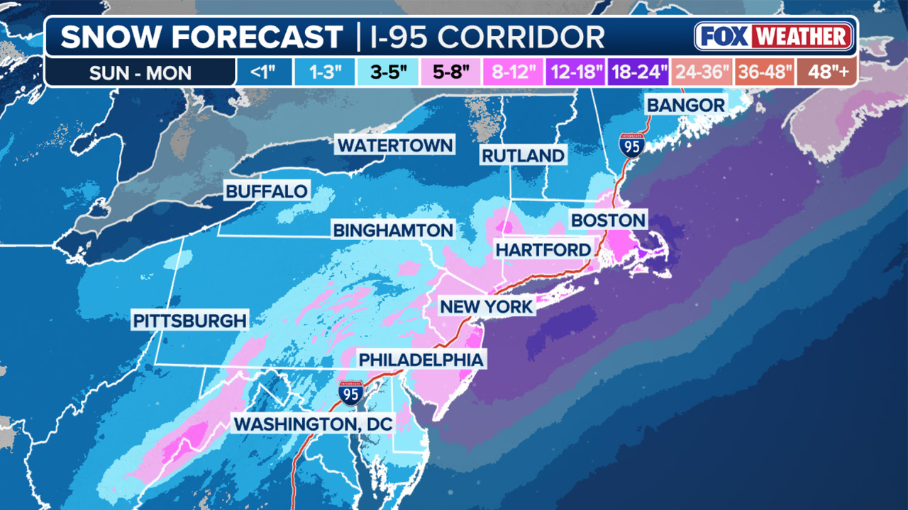
Forecasters expect: Snowfall totals NYC, Long Island, coastal CT: 13–18 inches likely, with locally higher amounts possibleInterior areas: 10–15 inches, with higher amounts possible Snowfall rates 1–2 inches per hour expected2 inches per hour or greater possible Sunday night into Monday morning Winds N/NE winds 30–35 mphGusts up to 55 mph possible along the coast
Blizzard conditions — defined as sustained winds or frequent gusts above 35 mph combined with falling or blowing snow reducing visibility to a quarter mile or less — are expected along the coast, including the NYC metro area.
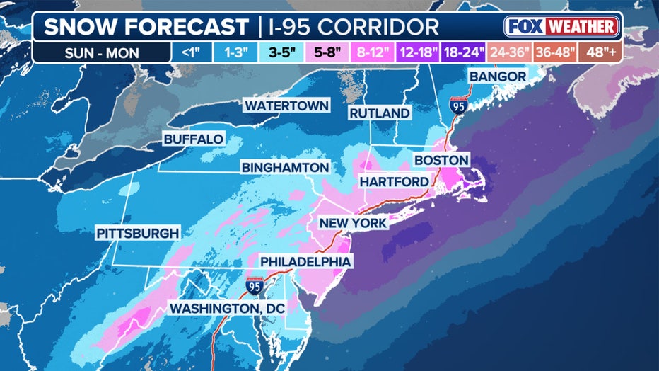
Updated snow potential for the Northeast. (FOX Weather) (Updated snow potential for the Northeast. (FOX Weather))
Stay connected with FOX LOCAL. For 24/7 winter storm coverage—Download Now.
Timing
According to the National Weather Service:
Sunday morning/afternoon: Snow develops, possibly mixing briefly with rain near the coast at the start7 PM Sunday – 12 PM Monday: Heaviest snow expectedLate Monday morning into afternoon: Snow tapers off Coastal and Marine Impacts
The storm is also expected to bring coastal flooding and hazardous marine conditions.
Widespread minor to moderate coastal flooding possible Sunday night into Monday morning high tide Localized overwash and dune erosion possible along ocean beaches Ocean waves could build to 12–16 feet Gale to storm-force marine conditions possible New Jersey impacts
Northeast New Jersey is under a Winter Storm Warning.
Snow totals of 10 to 15 inches are likely across much of northeast New Jersey, with locally higher amounts possible if heavier bands set up.
Snowfall rates could reach 1 to 2 inches per hour Sunday night.
Wind gusts up to 45 mph are possible, which could lead to blowing snow and reduced visibility.
Heavy, wet snow combined with gusty winds may result in scattered downed tree limbs and isolated power outages.
Connecticut impacts
Blizzard Warnings are in effect for coastal Connecticut.
Snow totals of 13 to 18 inches are likely along the Connecticut coastline, with higher amounts possible.
Interior southern Connecticut is under a Winter Storm Warning, where 10 to 15 inches are expected.
Snowfall rates of 1 to 2 inches per hour are possible Sunday night, with peak winds along the coast gusting up to 55 mph.
Blizzard conditions are expected along the shoreline, including whiteout visibility at times.
Why you should care:
Forecasters warn travel could become dangerous to impossible, especially Sunday night into Monday morning.
Heavy, wet snow combined with strong winds could lead to:
Downed tree limbsScattered power outagesWhiteout conditionsCoastal flooding in vulnerable areas
Residents are urged to finalize preparations Saturday, avoid unnecessary travel during peak storm hours and monitor official updates.
Stay ahead of the snow with FOX 5’s expert meteorologists, streaming LIVE on FOX LOCAL. We’re streaming nonstop coverage with the newest forecasts, snow potential, and preparation tips. Download FOX LOCAL for 24/7 weather coverage on your smart TV and mobile devices.
The Source: This article was written using forecast information from the National Weather Service, FOX Weather and FOX 5 NY meteorologists.