
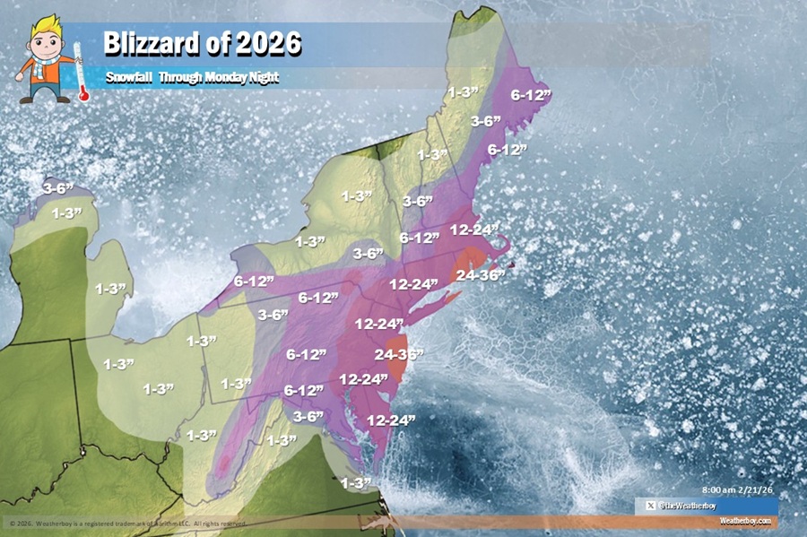
 Widespread areas of 1-2 feet of snow are expected from the Blizzard of 2026; some parts of New Jersey, New York, and southeastern New England could see over 2 feet of snow by Monday afternoon. Image: Weatherboy
A crippling blizzard is about to paralyze parts of New Jersey, New York, and southeastern New England with feet of snow and strong, potentially damaging winds. Because of this threat, the National Weather Service has issued Blizzard Warnings for southern Delaware, the entire Jersey Shore, all of New York City and Long Island, and coastal Connecticut; more could be issued for Rhode Island and Massachusetts too. Winter Storm Warnings are up further inland for interior southern Connecticut, the Lower Hudson Valley of New York, the balance of New Jersey and Delaware, southeastern Pennsylvania including the Philadelphia metro area. The National Weather Service says additional Warnings may become necessary.
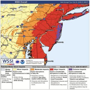 Extreme blizzard conditions will make travel impossible, especially along portions of the Jersey Shore and Long Island. Image: NWS
The ingredients for this major blizzard are coming together today. A frontal boundary stretching from Texas to the Southeast Coast will slowly sink south throughout the day today. Showers and thunderstorms will be possible along the boundary and will likely increase in coverage and intensity late this afternoon into tonight as low pressure consolidates and strengthens over the Southeast.
On Sunday, this area of low pressure will track northwards along the East Coast, and conditions will be favorable for rapid intensification off the Mid-Atlantic Coast late Sunday into Monday as the system interacts with a strong upper level trough/low. This system is forecast to become an impactful winter storm that will bring heavy snow and high winds to portions of the Mid-Atlantic and Northeast.
The highest impacts will likely be felt by coastal areas where the highest snow totals and strongest wind gusts are forecast. The combination of heavy snowfall and strong winds could result in blizzard conditions, especially from New Jersey into southeastern New England.
The National Weather Service says storm impacts will reach extreme levels in areas. “Travel will be extremely dangerous in these areas, and strong winds will likely result in power outages. In addition to winter weather hazards, strong onshore winds may also cause moderate coastal flooding, most likely from coastal Delaware to Long Island,” the National Weather Service warns.
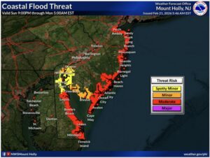 Coastal flooding will be a concern in New jersey and Delaware. Image: NWS
Some of the most serious coastal flood problems will be around New Jersey although a Coastal Flood Watch is up for southern Connecticut, all of Long Island, the Jersey Shore, and much of Delaware. Moderate coastal flooding is possible where up to 1-2 feet of inundation above ground level is possible in low-lying areas near shorelines and tidal waterways. Locally major coastal flood impacts are possible too. At forecast flood levels, widespread roadway flooding occurs in coastal and bayside communities and along inland tidal waterways. Some roads may become impassable and some damage to vulnerable structures may begin to occur.
Northeast winds will begin to increase on Sunday and persist through the day Monday, possibly into Monday night. The strongest of the winds are expected to occur Sunday night into Monday morning, with the Jersey Shore seeing the strongest along with eastern Long Island and southeastern New England. Wind gusts of 50-60 mph are possible at the coast and wind gusts up to 40 mph are possible inland. Gusty winds may lead to power outages and localized tree damage.
Before the snow stats, precipitation will likely begin as a period of light rain for most areas before changing over to snow during the late morning and afternoon hours from north to south. For areas north of I-78, precipitation will likely remain all snow.
By the time the snow wraps up later on Monday, very deep accumulations are expected. A widespread 1-2 feet of snow will fall across much of southeastern New England, southeastern New York, eastern Pennsylvania, New Jersey, eastern Maryland, and Delaware. An area of 2-3 foot snow totals is possible along portions of the Jersey Shore, eastern Long Island, southern Rhode Island, and southeastern Massachussetts.
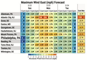 Severe wind gusts are possible from the blizzard, with the highest gusts expected along the shore. Image: NWS
Snow will fall at rates exceeding 2″/hour at times, especially in the Winter Storm Warning and Blizzard Warning zones. Snow at this rate will make travel impossible.
There could be isolated thunder snowstorms in the storm, especially over New Jersey. Lightning can be just as lethal in a snowstorm as a typical thunderstorm and the National Weather Service advises: “When thunder roars, head indoors. If thunder is close enough to be heard, lightning is close enough to kill.”
The last time a Blizzard Warning was issued for the New Jersey shore was 2022, where blizzard conditions were verified for Atlantic and Cape May counties along with portions of coastal Monmouth and Ocean counties.
For New York City, the last time a Blizzard Warning was issued there was March 2017.
A blizzard is defined by the National Weather Service as a severe winter storm lasting 3 hours or longer with sustained winds or frequent gusts of 35 mph or greater and considerable falling or blowing snow that reduces visibility to less than 1/4 mile. A blizzard is distinguished from a regular snowstorm by wind speed and visibility and not by snow accumulations.