
NEW YORK (WABC) — A major winter storm is rapidly intensifying off the mid-Atlantic coast, spreading heavy snow and wind across the Tri-State area, which is entirely under a Blizzard Warning through 6 p.m. Monday as a long-duration blockbuster snowstorm pummels the area.
The brunt of the storm unleashed Sunday evening and will continue overnight into Monday morning, and linger throughout the day, promising to paralyze swaths of the region. The storm’s scope is vast, spanning from Virginia to New England.
It’s an exceptionally rare setup with all 29 counties in our viewing area covered under the Blizzard Warning, something we haven’t seen since the Blizzard of 1996, and an upper-air setup resembling the Blizzard of 1978. Much of the area could see 12 to 18 inches, with areas farther east in line to receive two feet or more, depending on where heavy snow bands set up.
The National Weather Service has issued a blizzard warning for New York City and the Tri-State area on Sunday into Monday.Heavy Snow, Powerful Winds, and Dangerous Travel
Snow is piling up fast, with visibilities reduced, and winds ramping up to near-blizzard criteria. Temperatures have dropped below freezing faster than expected. That cold air will lock in overnight, allowing snow to accumulate quickly as the storm ramps up.
Roads that were wet and slushy this afternoon are becoming snow-covered, and travel is deteriorating rapidly tonight as the storm evolves into a full-blown blizzard.
Here’s what to expect overnight through Monday morning:
Near zero visibility
Wind gusts 45 to 60 mph, especially along the coast, with 70 mph gusts possible on the East End
Power outages, due to heavy, wet snow weighing down trees and wires
Coastal flooding, particularly along the South Shore of Long Island and the Jersey Shore, where 2 to 3 feet of inundation is possible in vulnerable back-bay areas during high tide
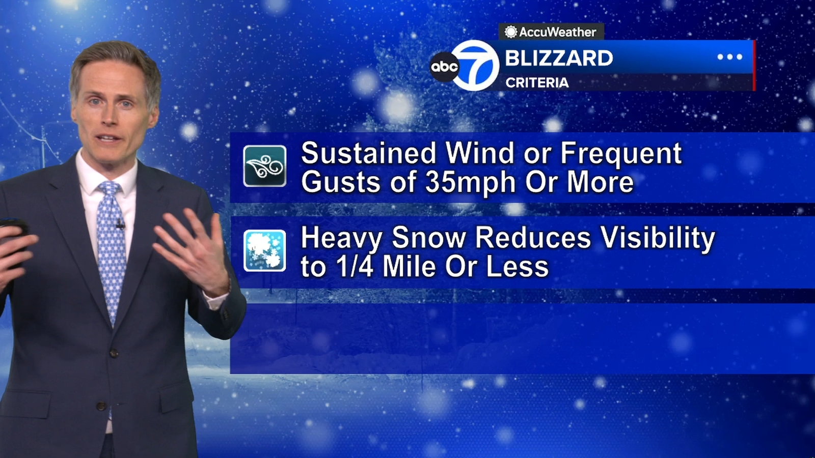
Blizzard Criteria Expected to Be Met for Hours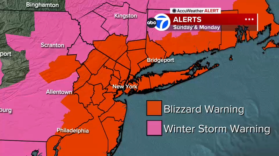
To qualify as a blizzard, conditions must include gusts over 35 mph, heavy snow, and visibility under a quarter-mile for at least three hours. Many parts of the region – even inland areas like Sussex, Poughkeepsie, and Newburgh – are likely to meet or exceed that threshold tonight into Monday.
Some coastal communities may endure 12 to 16 consecutive hours of blizzard conditions.
Heaviest Snow Tonight
The storm organizes and intensifies dramatically tonight. Futurecast shows widespread heavy snow by early evening, with the most intense snowfall likely from midnight through daybreak Monday.
Embedded snow bands could produce 2- to 3-inch-per-hour rates, and any location stuck under one of these bands for several hours could quickly rack up totals near two feet or more.
Two potential bands appear most likely to develop:
One stretching from New Jersey into the Hudson Valley. Another from Long Island down to the Jersey Shore
Snow Totals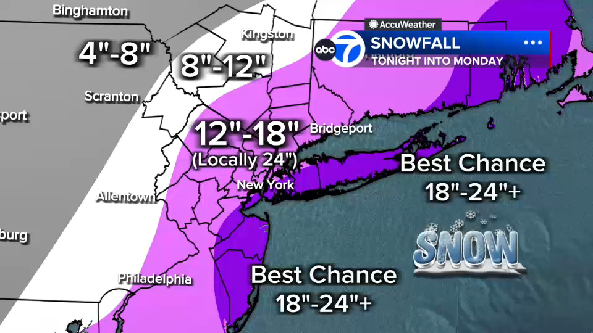
Widespread 12-18 inches across much of the region
Localized 18-24 plus inches in eastern Long Island, the South Shore of Nassau County, parts of the Jersey Shore and even parts of New York City
Under 12 inches farther north and west (e.g., Pike and Sullivan counties), where the storm’s moisture will be less concentrated
Monday: Blizzard in the Morning, Slow Improvement Late Day
Snow continues through Monday morning, remaining heavy at times, especially from the city eastward. Conditions finally begin easing midday, with snow tapering to lighter bursts late afternoon and evening. Winds, however, remain strong well into Monday.
LATEST ACCUWEATHER FORECAST
Meteorologist Dani Beckstrom has more on Sunday’s blizzard and the 7-day AccuWeather forecast.
An AccuWeather Alert remain in effect through Monday