
A major nor’easter has become a bomb cyclone and will continue to produce blizzard conditions in southeastern New England and coastal New York while the storm slowly subsides farther west on Monday.
Published Feb 21, 2026 2:57 PM EST
|
Updated Feb 23, 2026 9:32 AM EST
As a blizzard continues to sweep through the Northeast region of the U.S., many officials including New York Governor Kathy Hochul urge residents to stay indoors amid dangerous conditions.
A storm moving along the Northeast coast of the United States has rapidly strengthened into a bomb cyclone. Through much of Monday, the major nor’easter and blockbuster blizzard will focus its fury on coastal areas of New York and southeastern New England. Farther west, the heaviest snow will wind down in the zone from New Jersey and Delaware to Pennsylvania and Maryland. But, strong coastal winds will continue to create harsh, dangerous conditions and blowing and drifting snow.
“This is the first blizzard for much of the mid-Atlantic and southern New England coasts in about four years,” AccuWeather Senior Meteorologist Tyler Roys said.
“For New York City, the last time there was a blizzard warning in effect was during the storm from Feb. 8-9, 2017,” AccuWeather Senior Meteorologist Chad Merrill added. That storm brought 9.4 inches of snow to Central Park in Manhattan.
The blockbuster blizzard has all but shut down travel in a heavily populated, very busy region of the nation with road closures and thousands of flight cancellations and delays from this weekend to Monday. These effects will continue into Tuesday and perhaps Wednesday until aircraft and crews are relocated, schedules changed and crews have a chance to clear the snow.
This image of the bomb cyclone just off the coast of the northeastern United States was captured on Monday, Feb. 23, 2026. An eye-like structure, similar to a hurricane, was visible. (AccuWeather RealVue™ Satellite)
The flights that do operate will be subject to extensive delays due to deicing operations and runway maintenance. Airline effects from the coastal storm in the Northeast will ripple throughout the U.S. and to some extent on a global scale due to the volume of domestic and international flights handled by the hubs from Philadelphia and New York City to Boston.
From southeastern New York through southern New England, blizzard conditions will continue through much of Monday, with winds gusting to 35 mph or more and visibility dropping to one-quarter mile or less for at least three consecutive hours. As of mid-morning on Monday, there were approximately a dozen and a half official National Weather Service reporting sites that have experienced blizzard conditions in the coastal Northeast thus far, including Boston, Providence, Rhode Island, and Newark, New Jersey.
Compared to the storm from Jan. 24-26, which brought light-weight, dry, powdery snow, this storm, due to its heavy weight and clinging nature, will make shoveling difficult and dangerous for some individuals in poor health and might need to be left for professional removal.
This major winter storm has experienced “bombogenesis,” becoming a bomb cyclone by early Monday.
“Very simply, it’s a storm where its pressure drops 24 millibars in 24 hours (0.71 of an inch of mercury),” AccuWeather Meteorologist Bernie Rayno said. As pressure decreases, the storm intensifies and wind and precipitation increase as well, Rayno added.
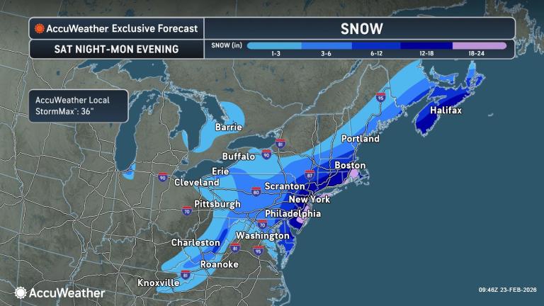
Across portions of New Jersey and Long Island, New York, through portions of southeastern New England, 18-24 inches of snow is forecast with an AccuWeather Local StormMax™ of 36 inches.
There may be even greater amounts of snow on the coast and well inland if the storm develops to its full potential and slows its forward speed. Snowfall rates of 1-3 inches per hour at times have occured and may overwhelm road crews, leaving some motorists stranded from New Jersey and New York to southeast New England.
Snowfall farther west in Pennsylvania, Maryland, Virginia, upstate New York, and West Virginia was highly variable from community to community and from road to non-paved surfaces from Sunday to early Monday. The effect of the February sun helped to minimize accumulation on road surfaces in many cases until Sunday evening. Melting will resume for several hours on Monday.
Thunder and lightning in a storm may be accompanied by flashes from transformer explosions. These conditions may explain some of the phenomena people were witnessing Sunday night.
“The clinging nature of the snow and high winds will put a strain on trees and power lines, with extensive power outages anticipated,” AccuWeather Meteorologist Alex Duffus warned.
Wind gusts will frequently reach 35-60 mph along the mid-Atlantic and New England coasts. Despite the wet nature of the snow, winds will be strong enough to cause extensive drifting in coastal areas.
The strong northeast winds during part of the storm will qualify it as a major nor’easter.
The angle of the winds will push Atlantic water toward part of the coast for a time, leading to minor to moderate flooding at times of high tide from Delmarva to New Jersey, New York and eastern Massachusetts. Significant beach erosion is expected from Delmarva to Massachusetts.
While temperatures will hover near or above freezing in the heavy snow areas for a time on Monday, colder air will move in later in the day and at night, which will cause some areas of slush and standing water to freeze, unless treated.
Have the app? Unlock AccuWeather Alerts™ with Premium+
Blustery and colder conditions are in store for Monday night and Tuesday in the Northeast, but the February sun effect will bring some natural melting for several hours on Tuesday.
This will be a striking contrast to the aftermath of the storm in mid-January, which was followed by weeks of persistent cold. Still, freezing cycles at night will lead to fresh areas of ice on streets, sidewalks and parking lots on a daily basis this week.
A clipper-style storm with snow and a wintry mix is forecast to travel from the northern part of the Great Lakes to the Northeast states by midweek.
More stories of interest:
Want next-level safety, ad-free? Unlock advanced, hyperlocal severe weather alerts when you subscribe to Premium+ on the AccuWeather app. AccuWeather Alerts™ are prompted by our expert meteorologists who monitor and analyze dangerous weather risks 24/7 to keep you and your family safer.