
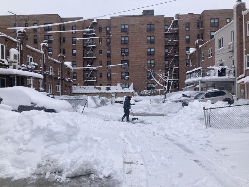
Whitestone was Whitestuff as the blizzard of 2026 blanketed Queens and much of the East Coast with snow Sunday and Monday, with the deepest depths in the borough listed by the National Weather Service measured there — though the numbers may not be definitive and others were virtually the same.
Queens’ northernmost neighborhood had 23 inches on the ground at 1:39 p.m. as the bomb cyclone nor’easter slowed down, according to a measurement from a member of the public.
Right behind it was LaGuardia Airport, where an official NWS observer recorded 22.5 inches at 2 p.m. Straight south of the midpoint between LGA and Whitestone, Howard Beach was a near match with 22 inches measured by a trained spotter at 3:30 p.m. Neighboring Kennedy Airport had a touch less, 20.1 inches, when the NWS took a look at 2 p.m. Just about 20 inches also were seen in Elmhurst and Jackson Heights in the afternoon, while South Jamaica posted 21 inches at 10:07 a.m.
The NWS also posted some of the highest wind gusts recorded, showing 64 mph in Kew Gardens Hills, 62 at Kennedy, 52 at LaGuardia and 50 at Breezy Point in the Rockaways.
While Queens got its share of wind-driven snow, other parts of the region took more severe hits. Parts of Staten Island and Central Suffolk County saw 29 or 30 inches of snow, while Montauk Point recorded a wind speed of 84 mph at one point.
The snow total in Central Park, the “official” New York City measurement, was 19.7 inches at 2 p.m. Monday, making the storm the ninth biggest in recorded history for the Big Apple, according to the NWS, which has a list of the top 28.
The biggest brought 27.5 inches from Jan. 22 to 24, 2016, followed by 26.9 on Feb. 11 and 12, 2006, for second place, and 26.4 from Dec. 26 to 27, 1947, for third place.
In fourth place is the earliest storm on the list, recorded March 12 to 14, 1888, when 21 inches came down.
New York City schools were closed Monday in the first genuine snow day, with no attempt at remote learning, since 2019, but were reopened Tuesday. According to Mayor Mamdani, the state Department of Education granted the city a waiver from the requirement that it have 180 days of school during the academic year in order to allow Monday’s closure. Mamdani took some criticism for ordering schools reopened Tuesday.
All Queens Library locations were closed Monday and reopened Tuesday.
The Metropolitan Transportation Authority says to go to mta.info for the latest on subways, buses and the commuter railroads.
“There are ongoing changes to service on subways, buses, the LIRR, Metro-North Railroad, and Access-A-Ride because of the winter storm,” the agency says. “Please use caution while traveling, and check service status before you go.”
On subways, it says, “Some express trains are running local. Check the MTA app or Service Status to see if your train is impacted.”
On buses, it says, “Expect longer waits for local buses, since we’ve removed articulated buses from service during the storm.”
Of the Long Island Rail Road, which reduced service Sunday night and shut down altogether at 1 a.m. Monday, it says, “The LIRR plans to operate limited service beginning 4 a.m. Tuesday on the Ronkonkoma, Huntington, Babylon, Oyster Bay, Montauk, and Port Washington branches,” then detailing what that means on each line.
Alternate-side parking has been suspended from Monday through Saturday, Feb. 28.
Thousands of flights were canceled at the airports. As of Monday morning, the Port Authority of New York and New Jersey’s websites for Kennedy and LaGuardia still showed that no flights were going in or out. Among the scores of current cancellations, the airports listed some flights as only delayed, until Monday afternoon.
Con Edison’s website showed limited outages Monday morning, with the highest power failures in Queens being in the northwestern quadrant of the borough, where 249 customers were out. The next highest number was 30 in northern Queens. Otherwise there were just handfuls of customers out in various parts of the borough.
Mayor Mamdani declared an emergency ahead of the storm as well as a travel ban that forbade all nonessential use of private automobiles and powered bikes and scooters on city streets from 9 p.m. Sunday to 12 p.m. Monday. There were exceptions for vehicles providing emergency services and the like.
It is recommended that drivers clear all snow and ice from their vehicles before driving. Anyone operating a motor vehicle with snow obstructing their vision can be charged with reckless driving, a misdemeanor, various media outlets say.
Under its instructions for “How to Drive in Winter,” the Department of Motor Vehicles says, “During ice or snow storms, do not drive unless you must. If you must drive, first clear the ice and snow from your vehicle. This includes the headlights and back lights, the windshield wipers, the hood and roof of your vehicle, and all of the windows. Make sure the windshield washer reservoir is filled with a cleaning solution that resists freezing.”
Legislation specifically making it illegal to drive without clearing all snow and ice off a car, including from the roof, has been introduced periodically over the years but has never gone anywhere.
Multiple traffic signals were malfunctioning Monday morning, something observed in Central Queens, at least, for the last week.
One key thing that looks better about this storm than the one a few weeks ago is that it will not be followed by a string of freezing days. Aside from Tuesday, when the Central Queens high is expected to be 27, daytime temperatures over the next week are forecast to reach the upper 30s and low 40s. Snowfall No. 9 will dissipate over time.