

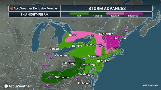
Lingering cold air will allow a storm to spread snow, sleet and freezing rain across parts of upstate New York and central and northern New England from Thursday night into Friday. The late-week winter storm follows snow and ice from Tuesday in much of the same region.
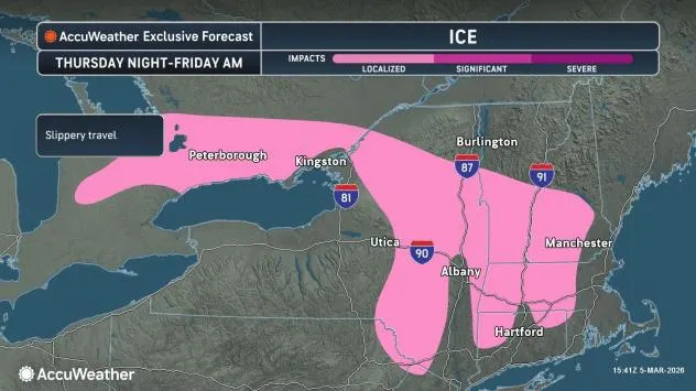
A small to moderate buildup of ice is likely on elevated surfaces and untreated roads, parking lots and sidewalks from parts of Ontario to eastern New York, including areas north of New York City, as well as much of Vermont and New Hampshire, western and central Massachusetts and northwestern Connecticut.
AccuWeather.com
Icy conditions will be worse in areas sheltered from the sun, where surfaces will remain colder than surrounding locations.
Not enough ice is likely to accumulate on trees and power lines, leading to widespread power outages. However, some sporadic outages are possible in heavily wooded areas, which will be due, in part, to clinging wet snow.
AccuWeather.com
Even though the snow and ice will largely miss the major airport hubs in the Northeast, flight cancellations are possible at the regional hubs as deicing operations lead to some delays.
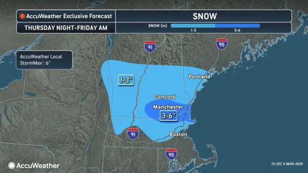
A general 1-3 inches is expected from northern Massachusetts into southern and central Vermont and New Hampshire, as well as southwestern Maine. Locally higher totals are likely, with an AccuWeather Local StormMax™ of 6 inches. The snow will fall at a heavy pace at night into the first thing on Friday, boosting the accumulation rate and potentially leading to a slippery morning commute, including in the Boston metro area.
AccuWeather.com
This storm is expected to be the last in a recent series of snow and ice events across the Northeast.
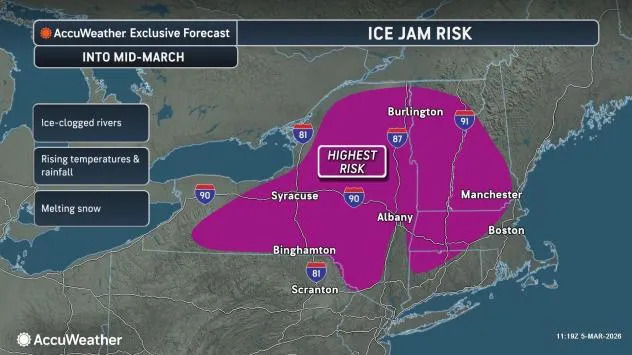
From this weekend into the first half of next week, a significant warming trend is expected to bring the highest temperatures of the year so far. As warmer, moist air flows over the cold ground and snow and ice cover, areas of dense fog may develop. Possibly the warmest conditions since mid-autumn may unfold on Monday and Tuesday.
As a consequence of the upcoming thaw, there will be a risk of ice jams in areas where streams and rivers are still clogged with ice.
AccuWeather.com
The warmer conditions will lead to slushy or spring skiing on many slopes this weekend through next week.
Want next-level safety, ad-free? Unlock advanced, hyperlocal severe weather alerts when you subscribe to Premium+ on the AccuWeather app. AccuWeather Alerts™ are prompted by our expert meteorologists who monitor and analyze dangerous weather risks 24/7 to keep you and your family safer.