

Hope you were able to enjoy the seasonably nice weekend, because a storm looks to put a damper on Monday.
Scattered showers arrived after midnight Monday. Showers will be consistent for the rest of morning, and while an occasional rumble of thunder may be heard, the main event doesn’t arrive until Monday afternoon or early evening.
Some of the storms in the afternoon could be severe and bring isolated flash flooding.
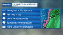
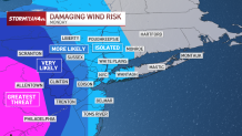
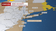
A line of storms will push in ahead of a cold front bringing with it the likelihood of severe wind gusts around 50-60 mph. A wind advisory for parts of the tri-state, including New York City, will be in effect Monday afternoon.
With the arrival of the line of storms, we could see severe thunderstorm warnings issued as a result of damaging winds. Heavy rain and flooding is also a concern, especially over Connecticut where a flood watch has been issued.
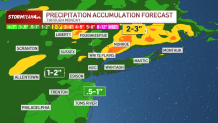
Rainfall totals of 2-3 inches are possible in Connecticut. The rest of the tri-state is looking at 1-2 inches to fall in all, with an inch or less down the Jersey Shore.
All that rain could lead to flooding, especially along the coast and near rivers.
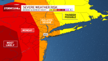
It appears that the worst of the storms will be between 6 p.m. and midnight. Much of the tri-state has a chance to see isolated severe weather, with increasing chances for severe weather farther and south and west of the city, closer to Philadelphia.
The greatest risk for damaging wind is in western New Jersey, where there is a remote chance for tornados.

Colder air follows the front and it could even be possible to see some snowflakes early Tuesday — nothing that will stick, though.
St. Patrick’s Day looks to be windy and cold, with wind chills in the teens and 20s all day. Temperatures bounce back to the 50s by the end of the week.