
NEW YORK (PIX11) — It may take a bit of time to get the temperatures up to snuff in the tri-state area, but at least the sun will be out to play.
Rain swept through New York and New Jersey over the weekend, and a cold front is right behind it. Sunday night temperatures will lower into the high 30s and low 40s as we move into Monday.
Peak temperatures should hover around 55 degrees in Manhattan and just a tick lower in the surrounding areas of Long Island and New Jersey.
Tuesday’s forecast looks roughly the same, albeit with slightly cooler temperatures, but Wednesday is shaping up to be chilly.
Morning wind chills could be in the 20s with highs below the 50-degree mark for the day. The sun will be shining, but you’re going to want to grab your coat. Thursday will mark a nice rebound with sun and temperatures near 60 degrees.
Stay connected with community stories that matter: Visit our homepage
Friday through Sunday is looking like the sweet spot for getting outdoors and soaking up sunrays.
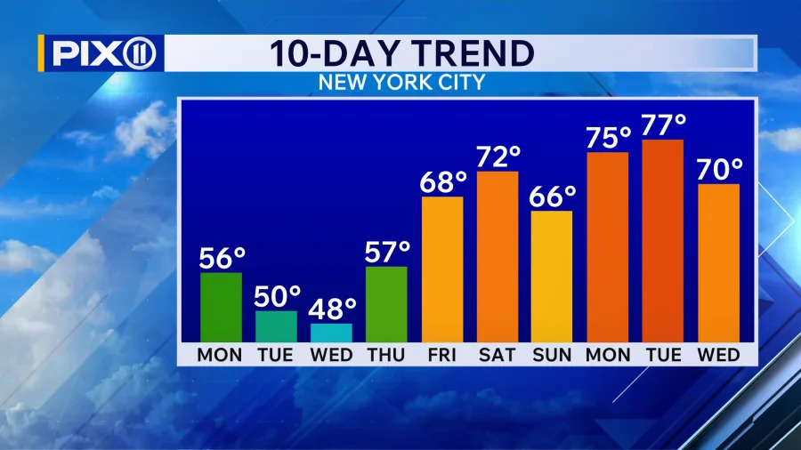
Ten-day trend for temperatures in New York City from Monday, April 6, to Wednesday, April 15, 2026. (Credit: PIX11)
High 60s and even into the 70s on Saturday have potential for nice strolls in the park, putts on the golf course and maybe even a bike ride if you’re up for it.
It could be a sign of sustained warmth in the tri-state as spring rolls along.
Spencer Gustafson is a digital content producer from Long Island who has covered New York state and city news since 2023. See more of his work here.
Copyright 2026 Nexstar Media, Inc. All rights reserved. This material may not be published, broadcast, rewritten, or redistributed.
For the latest news, weather, sports, and streaming video, head to PIX11.