
Heat surges Tuesday before ‘unusually intense’ storms late across Vermont, New York
Tuesday night’s setup has the potential to produce the biggest storms of the summer so far
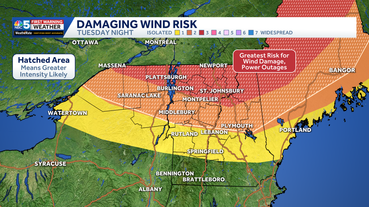
It’s going to be very warm, very humid. I don’t think we have to worry about thunderstorms until very late today. So if you’re doing something outdoors, you’ll be OK as long as you take heat precautions. We’ve got *** heat advisory up until 8:00 p.m. for *** heat index between 95 and 105 degrees. This alert covers. All of Vermont, all of our New Hampshire counties, and everything but the Adirondack Park in northern New York, the actual air temperatures meanwhile anywhere from about 90 in Saranac Lake to 98 in Burlington. We’ve got *** west wind which can sometimes give us our hottest days of the summer. And with the high humidity, it will, it’ll feel uncomfortable outside later today. The one thing to consider for the storm forecast is the presence of wildfire smoke that may shave *** couple of degrees off the temperatures, which may bring the storm potential down. I don’t think it has that much of an impact. But you will notice some hazy sunshine through the day as well. Uh, one thing we’ve been watching closely in the weather center is this initial round of thunderstorms which is diving straight towards Quebec City. Now if you just sort of eyeball where it’s going, it mostly misses to the east and it likely weakens on approach, but I could see *** scenario in *** few hours’ time where maybe the west. The edge of this eclipse parts of the northeast kingdom. Maybe we get *** couple of thunderstorms later this morning, but with *** setup like this, it’s very much wait and see, touch and go, so we’ll just keep following it and monitoring it as it gets closer. Meanwhile, this little line of downpours south of Moosanee, that’s our main thunderstorm threat coming late this evening into the overnight. So the storm Prediction Center has the same outlook as yesterday. 3 out of 5 risk in northern Vermont, northern New York, in this orange area, that’ll be the most likely spot to see wind damage and power outages, the risk decreasing as you go farther to the south. I think southern Vermont misses out on the storm potential this time around. For more on exactly what we’re dealing with later today, we’ll bring in meteorologist Marissa Vijeviny. Well, Ben, some of these storms could without *** doubt. Intense with lightning, torrential rainfall, but what we’ve been really trying to write home is the damaging wind threat. We’ve been mentioning how we haven’t had *** threat look like this in over 2 years, so we are expecting some straight line wind damage with gusts possible over 75 MPH in this orange shading. Hail is also something we’ll be watching closely near the international border. We could see it anywhere between 1 and 2 inches in diameter and also there is enough instability and rotation in the atmosphere that we could see even *** strong tornado, EF2, or weaker than that as we roll forward again. This is not to say every town in those areas will see *** strong thunderstorm or *** tornado, but it is certainly possible the ingredients are there. Here are some things to. Consider later on this evening and into the overnight charge your cell phones so you make sure you get access to weather alerts around the clock of course make sure you’re, you have *** sturdy place to stay tonight and parking away from trees is also *** good idea as well, especially those weaker and older ones. Ben, and you’ll give us *** run through Futurecast. Yeah, we’ll show you the hour by hour timing here again. We’re nice and quiet through the daylight hours. We don’t have to. Worry about storms until after 6 p.m. *** couple of weather models do have some cells coming through around this time. I think the more active window will be about 9 p.m. onwards. That’s when some of these cells start to dive in from Canada, northern New York, northern Vermont looking real intense by 11 o’clock, midnight, and then everything starts to fall apart as we go through Wednesday morning, maybe *** few lingering downpours to start off the day. But the severe threat will be long gone by then. The smoke does stick around tomorrow that may result in some air quality impacts, but the humidity will be much lower. The rest of the week is cooler with low 80s by the upcoming weekend. Adrian.
Heat surges Tuesday before ‘unusually intense’ storms late across Vermont, New York
Tuesday night’s setup has the potential to produce the biggest storms of the summer so far

Updated: 7:47 AM EDT Jul 14, 2026
NBC5 meteorologists are continuing to track extreme heat and high humidity Tuesday afternoon, along with the potential for intense thunderstorms Tuesday evening and overnight.Air temperatures will climb into the 90s by midday, but with very high humidity, the heat index will easily exceed 100 degrees at times.Strong sunshine and muggy air will provide plenty of energy for thunderstorms to become severe. At the same time, strengthening winds higher in the atmosphere will help storms organize and intensify. Damaging winds remain the primary threat, but large hail and an isolated tornado are also possible.As always, not every town will be impacted. But those that are could be dealing with significant damage.Damaging straight-line wind gusts in excess of 75 mph are possible, along with large hail and a few tornadoes.One tornado could become strong, meaning EF2 intensity or greater (111+ mph winds). While the greatest potential extends into parts of Canada and Maine, this threat also includes portions of the immediate NBC5 viewing area.Only NBC5 will have direct access to a network of local storm chasers on the ground Tuesday evening, bringing you the latest life-saving information as the storms unfold.Watch the video for more.Want more local news? Download our NBC5 mobile app for iOS and Android. STAY WEATHER-AWAREFor the latest weather coverage for your area, click here. Stay updated with alerts in the myNBC5 app, which you can download here.For the best weather information and Vermont and northern New York’s Certified Most Accurate forecast, watch NBC5 News by streaming at this link.Don’t forget to follow NBC5 News on Facebook, X (formerly Twitter), and Instagram.Follow the NBC5 First Warning Weather team on social media:Chief Meteorologist Tyler Jankoski Facebook | X | InstagramMeteorologist Ben Frechette Facebook | X | InstagramMeteorologist Matt DiLoreto Facebook | XMeteorologist Andrew Grautski Facebook | XMeteorologist Marissa Vigevani Facebook | X
SOUTH BURLINGTON, Vt. —
NBC5 meteorologists are continuing to track extreme heat and high humidity Tuesday afternoon, along with the potential for intense thunderstorms Tuesday evening and overnight.
Air temperatures will climb into the 90s by midday, but with very high humidity, the heat index will easily exceed 100 degrees at times.
Strong sunshine and muggy air will provide plenty of energy for thunderstorms to become severe. At the same time, strengthening winds higher in the atmosphere will help storms organize and intensify. Damaging winds remain the primary threat, but large hail and an isolated tornado are also possible.
As always, not every town will be impacted. But those that are could be dealing with significant damage.
Damaging straight-line wind gusts in excess of 75 mph are possible, along with large hail and a few tornadoes.
One tornado could become strong, meaning EF2 intensity or greater (111+ mph winds). While the greatest potential extends into parts of Canada and Maine, this threat also includes portions of the immediate NBC5 viewing area.
Only NBC5 will have direct access to a network of local storm chasers on the ground Tuesday evening, bringing you the latest life-saving information as the storms unfold.
Watch the video for more.
Want more local news? Download our NBC5 mobile app for iOS and Android.
STAY WEATHER-AWARE
For the latest weather coverage for your area, click here. Stay updated with alerts in the myNBC5 app, which you can download here.
For the best weather information and Vermont and northern New York’s Certified Most Accurate forecast, watch NBC5 News by streaming at this link.
Don’t forget to follow NBC5 News on Facebook, X (formerly Twitter), and Instagram.
Follow the NBC5 First Warning Weather team on social media: