
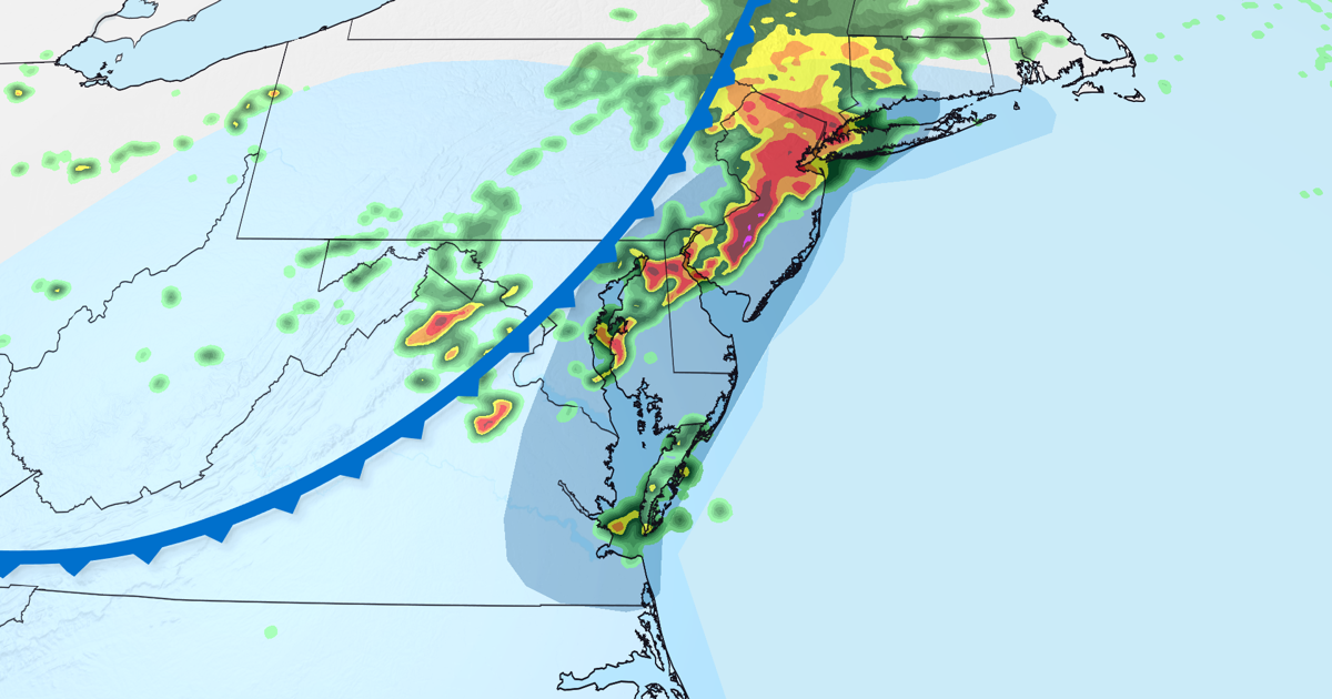
(CNN) — Drenching storms are sweeping through the East Coast, bringing with them the threat of significant flash flooding, damaging wind gusts, and tornadoes.
⛈️☔️Live in the Northeast? Track the storms, find out your local risk and get more detailed timing from meteorologists in the CNN Weather app ⛈️ ☔️
New York City, parts of New Jersey and eastern Pennsylvania, including Philadelphia, are under a Level 3 of 4 flooding rainfall risk. This is where “numerous instances of flash flooding are likely,” the Weather Prediction Center said.
All told, more than 29 million people are in flood watches along the Interstate 95 corridor in the Northeast; they stretch as far north as southwest Connecticut to as far south as northern Delaware.
The heaviest rain is ongoing in these areas and will continue for the next two to three hours with rainfall rates over an inch per hour in some locations, including parts of New York City. Evening commuters could encounter serious disruptions.
As the storms moved across the Mid-Atlantic this afternoon, a man died after being struck by lightning on a beach in Cape Charles, Virginia, CNN affiliate WVEC reported, citing the town manager. A woman with the man was also struck but suffered only minor injuries, according to WVEC. CNN has reached out to officials for more details.
At least two tornadoes have been observed across the Mid-Atlantic, with more likely to be confirmed after the National Weather Service completes damage surveys.
“Significant damage” including flooding and downed trees has been reported throughout Dover, Delaware, after a “likely” tornado hit the city, according to the Dover Police Department. Emergencies crews were actively responding, and the city declared a state of emergency Thursday evening, the police said.
A tornado was spotted in Columbia, Pennsylvania, as severe storms marched through southeast parts of the state.
In New York City, flooding closed portions of several major roadways, including the Brooklyn Queens Expressway and the Long Island Expressway in Queens. City authorities also warned commuters of delays and service changes on “MTA trains across NYC.”
The storms are being generated by a cold front that already caused flash flooding in central Ohio early Thursday morning. Multiple water rescues and road closures were reported near Columbus, Ohio, according to CNN affiliate WBNS.
The Northeast storms won’t last long, but some will wring out very intense rain falling at rates of 1 to 3 inches per hour.
Heavy bursts of rainfall like this are notorious for causing flash floods, especially in urban locations in the East. New York City’s aging sewer infrastructure can only handle around 1.75 inches of rain per hour before it’s overwhelmed and flash flooding can occur
Extreme rainfall rates are becoming more common as planet-warming pollution pushes temperatures higher because warmer air holds more moisture. Weather systems can then wring that moisture out like a water-laden sponge, yielding heavy and often highly localized downpours.
Most locations will see at least 1 to 2 inches of rain, but areas hit by multiple storms or the most intense rainfall rates could receive up to 3 to 5 inches of rain in just a couple of hours.
Some storms could intensify
Some of the storms could intensify enough to bring damaging winds and hail in many of the same areas at risk for flooding.
Damaging wind gusts are expected to be the most widespread threat, especially from the southern half of New Jersey to Philadelphia, Baltimore and Washington, DC. The most intense bursts of wind could down trees and knock out power.
This same general area also has the biggest risk of isolated tornadoes.
Much of the flooding rain and severe storm threats should end around midnight as the cold front pushes off the East Coast.
The-CNN-Wire
™ & © 2026 Cable News Network, Inc., a Warner Bros. Discovery Company. All rights reserved.
CNN’s Isa Mudannayake contributed to this report.