
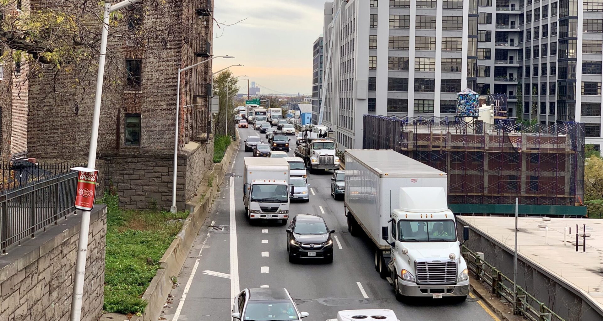
BROOKLYN HEIGHTS — Mayor Zohran Mamdani and New York City Department of Transportation Commissioner Mike Flynn have unveiled the broad outlines of a 10-year, $4 billion plan to rehabilitate the city-owned portion of the Brooklyn-Queens Expressway between Atlantic Avenue and Sands Street.
This section, dubbed “BQE Central,” includes the triple cantilever underlying the historic Brooklyn Heights Promenade.
“Time is up. We are fixing the triple cantilever,” Flynn told reporters on a press call Thursday. He said the city has “kicked the can down the road” long enough, and immediate action was needed to ensure the safety of drivers and minimize the likelihood of massive traffic diversions through Brooklyn neighborhoods.
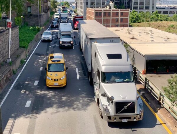 More than 130,000 vehicles — including 13,000 trucks — travel along the BQE’s triple cantilever every day. Photo: Mary Frost/Brooklyn Eagle
Mamdani, on vacation Thursday, was not on the call, but said in a statement that the city could not afford to wait for the “perfect solution.”
“We’re going to fix the aging concrete, repair the deteriorating triple cantilever and build temporary roads that keep the highway operable during construction to avoid sending tens of thousands of cars and trucks onto local streets,” the mayor said. “This plan allows us to safely fix the BQE without slowing our city down or wasting decades more on magical thinking.”
 This schematic shows the construction area of the city’s planned BQE Central rehabilitation. Diagram: NYCDOT (Diagrams preliminary and subject to change.)
BQE will remain 2 lanes
Flynn made clear the city considers the job to be a city-led rehabilitation and stabilization of the existing structure to keep it standing, rather than a grand redesign. The path forward is to “fix the structure, keep traffic off local streets while we do that, and not expand the current footprint,” he said.
No federal funds will be sought and no federal review will be necessary for the work on this city-owned section of the highway. The usual gamut of city environmental and land-use reviews will take place before construction begins.
The rehab will retain the existing, two-lane configuration, bringing it into a state of good repair but not expanding it. “We will just address the areas that need it,” Flynn said. The work will focus on replacing the deck joints, deteriorating concrete and rebar, with possible upgrades to draining, railing and lighting systems and hardware, but wouldn’t involve work on interchanges or local streets. The expected useful lifetime of the rehab would be roughly 40 years.
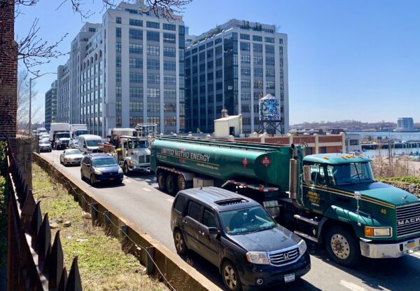 The Queens-bound BQE along the Brooklyn Heights waterfront. Photo: Mary Frost/Brooklyn Eagle
The landmarked Promenade, which is under the purview of the city’s Parks Department, would be repaired in phases so a portion could remain open and accessible at all times. “We know how valued an asset the Promenade is to the community and the city at large,” Flynn said.
The highway’s infrastructure is already 20 years past its design life and is deteriorating under the weight of 130,000 vehicles — including 13,000 trucks — every day, more than double the capacity for which it was designed, according to DOT.
Limiting traffic lanes to two in each direction, performing spot repairs and installing a high-tech Weigh-In-Motion system to keep overweight trucks off the highway has extended the triple cantilever’s viable lifetime, and the BQE remains safe for now, DOT said.
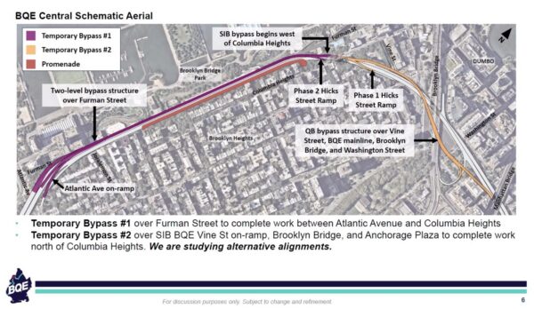 BQE Temporary Bypass #1 can be seen in purple. Temporary Bypass #2 is shown in yellow, but alternatives are being considered. Diagram: NYCDOT (Diagrams preliminary and subject to change.)
Plan involves 2 bypasses
The triple cantilever consists of three decks overhanging Furman Street, which runs at ground level next to Brooklyn Bridge Park.
The bottom two decks carry traffic, and the top deck is the landmarked Promenade. The upper vehicular deck carries two lanes of northbound (Queens-bound) traffic. The lower vehicular deck carries two lanes of southbound (Staten Island-bound) traffic.
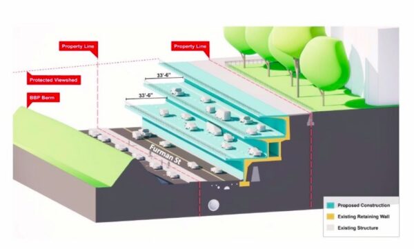
The city plans to build two temporary highway bypasses: the first, a two-level bypass on top of Furman Street, below the Promenade, from Atlantic Avenue to Columbia Heights. This will be no higher than the existing Queens-bound highway and will not affect the Promenade, Flynn said.
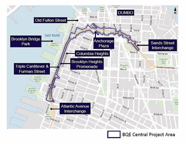 This map shows the city’s BQE Central project area. Diagram: NYCDOT (Diagrams preliminary and subject to change.)
This bypass will be fundamentally different from a controversial bypass the city previously considered, he emphasized. (The earlier bypass Flynn referred to, proposed under the de Blasio administration and reviled by the community, would have built a six-lane “Highway from Hell” where the Promenade currently stands.)
The temporary bypass structure along Brooklyn Bridge Park will sit in Furman Street’s right-of-way, DOT told the Brooklyn Eagle. Access to Brooklyn Bridge Park from Furman Street will be maintained throughout construction.
A second elevated bypass would extend from Columbia Heights, over the Brooklyn Bridge approach, to the Manhattan Bridge. (This bypass would run over the Staten Island bound BQE Vine Street on-ramp, the Brooklyn Bridge approach and Anchorage Plaza, in order to complete work north of Columbia Heights.)
However, this second bypass is still under study and the plan could change, Flynn said: “We’re looking at alternative alignments for that because we know that that could be pretty impactful, and we’re hoping that we can find other ways to make it work that would be less impactful.”
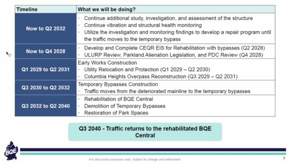 A preliminary timeline of the proposed rehab of BQE Central. Chart: NYCDOT (Timeline is subject to change.)
Preliminary timeline
The rehabilitation will break ground in 2030 after preliminary planning, according to DOT’s timeline. “This reflects the shortest-term rehabilitation plan needed to keep the structure safe and stable while also allowing the city to work with the state, which controls the northern and southern segments of the BQE, on a long-term vision for the entire highway,” DOT said in a statement.
Until the BQE is closed and traffic rerouted onto the bypass, projected to take place in the first half of 2032, DOT plans to carry out studies and assessment of the structural health of the highway, and do interim repairs as needed.
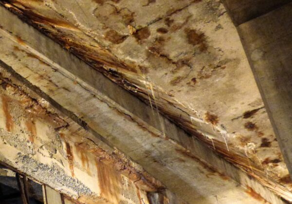 This 2018 photo shows the rusting underside of one level of the BQE’s triple cantilever. Photo: Mary Frost/Brooklyn Eagle
Between now and the end of 2028, the city will develop and complete the City Environmental Quality Review, Environmental Impact Statement, Uniform Land Use Review Procedure and Public Design Commission review, and obtain state Parkland Alienation legislation, “mainly for the construction impacts,” Flynn said. (The Promenade is parkland.)
From the start of 2029 to mid-2031, DOT will carry out utility relocation and protection procedures, and undertake the Columbia Heights Overpass reconstruction. The Eagle asked if there would be any change to the height of the overpass, as discussed during the Adams administration as a way to allow taller and larger trucks to travel along the highway. A city official answered that the Columbia Heights part of the plan was still early in the process, but the city does not anticipate any change in elevation.
Between 2030 and 2032, traffic will move to the completed bypasses. Starting in 2032 through 2040, the city will rehab the original BQE, and when completed, demolish the bypasses and fix up the park spaces. By the third quarter of 2040, traffic will return to the rehabilitated BQE.
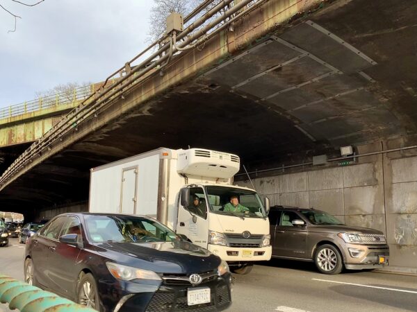 The Staten Island-bound BQE. Photo: Mary Frost/Brooklyn Eagle
Leaves door open for corridor-wide vision
A coalition of more than a dozen community and environmental justice organizations across Brooklyn and Queens has long been pushing for a total rethinking of the entire BQE span. Designed by Robert Moses more than 70 years ago, the highway has divided communities north and south of Brooklyn Heights, and has been polluting the air ever since. The planned rehab does not close the door to a more visionary redesign that would “right these wrongs,” Flynn said.
“What this really represents is the simplest, most expedient, lowest cost way to address the urgent needs of this major piece of infrastructure while minimizing impacts on surrounding communities, and leaving the door open to larger visions,” he said.
The city-owned portion of the BQE is roughly 10% of its full length, and any large-scale vision would have to include the full corridor, which would require partnering with the state and local communities “to make meaningful investments that improve safety, public space and quality of life for those communities,” he said.
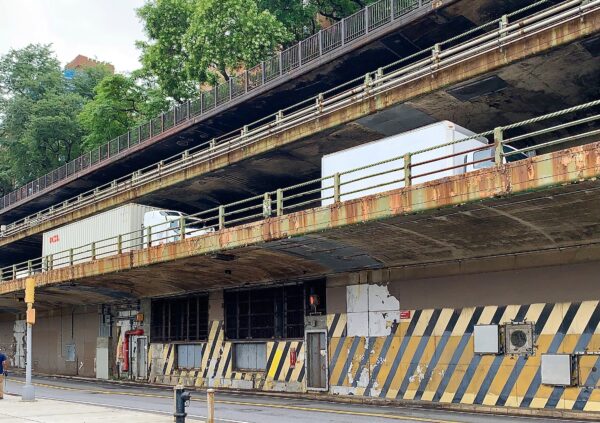 The triple cantilever consists of three decks overhanging Furman Street (shown here), which runs at ground level next to Brooklyn Bridge Park. Photo: Mary Frost/Brooklyn Eagle
Flynn said the city would engage “early and transparently” with all stakeholders, elected officials, communities, unions and partner agencies as the plan develops, and work to minimize and mitigate any negative impacts.
During a Q&A, a city official reiterated that intersections, including the Atlantic Avenue intersection, are under federal jurisdiction and would not be affected by the city’s rehab plan. Transportation advocates have urged authorities to close the BQE entrance ramp at Atlantic to prevent trucks from jamming small, local streets from Red Hook to Atlantic as an alternative to the highway.
DOT officials did not answer the Eagle’s question by press time about which local stakeholders, if any, had been involved in developing this preliminary plan.