

What to KnowTuesday night is expected to be mostly clear, but light winds will set the stage for the coldest night of the season since May.A frost advisory is in effect from 11:00 p.m. to 9:00 a.m. Wednesday for Orange and Putnam counties, as well as inland areas of southern Connecticut and Sussex County in New Jersey.In other areas, temperatures will drop into the high 30s and low 40s, while the New York metropolitan area will stay closer to the mid and upper 40s.
Tuesday began with cool and windy conditions across the tri-state area, with gusts from the northwest continuing into the early afternoon before easing off later. But things could change overnight.
Mostly clear skies are expected Tuesday night, but light winds will set the stage for the coldest night of the season since May.
Frost is expected in inland areas, with the possibility of isolated temperatures at or below freezing.
A frost advisory is in effect from 11 p.m. to 9 a.m. Wednesday for Orange and Putnam counties, as well as inland areas of southern Connecticut and Sussex County, New Jersey.
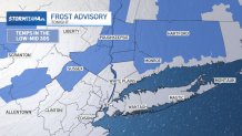
Storm Team 4Storm Team 4
Elsewhere, temperatures will drop into the upper 30s and 40s, while the New York metropolitan area will remain closer to the mid- to upper 40s.
Check out the latest alerts in your area here.

Storm Team 4Storm Team 4
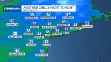
Storm Team 4Storm Team 4
On Wednesday we will have a rapid rise in temperatures, with highs again near 70 degrees. This is to the delight of ticket holders for Game 3 of the American League Divisional Series between the New York Yankees and Tampa Bay Rays in the Bronx.

Storm Team 4Storm Team 4
Then comes a much warmer Thursday, when some parts of the region could climb into the 70s.
Most of the week and much of the weekend will remain dry. The next chance of rain would not arrive until Sunday night and Monday, and could be associated with tropical humidity.
Weather forecast for the next few days
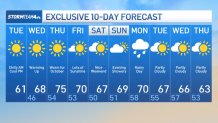
Storm Team 4Storm Team 4