

NEW YORK (WABC) — Enjoy the dry weather on Saturday because Sunday is shaping up to be a soggy finish to the holiday weekend as the remnants of Hurricane Isaias brings soaking rain and travel impacts to the Tri-State area.
Saturday remains the better day of the weekend. High clouds associated with the storm will filter the sunshine at times, but conditions will stay dry and pleasant. Temperatures are expected to reach the mid-60s, with some inland areas of New Jersey approaching 70 degrees. The day may begin with a picturesque sunrise as high clouds drift overhead. Fall foliage viewing will also be favorable north and west of Interstate 87, with the Catskills near peak color.
Clouds will continue to increase Saturday night, but most areas should remain dry overnight.
The weather turns significantly wetter on Sunday. A few showers may arrive before dawn, but the heaviest rain is expected during the afternoon and evening. Travel should remain manageable during the first half of the day, but conditions are expected to deteriorate later as periods of heavy rain develop.
Rainfall totals of 1 to 2 inches are likely across much of the region, with localized amounts of 2 to 3 inches possible where heavier downpours persist. Eyewitness News meteorologists are watching the possibility that the circulation associated with what was once Isaias could pass directly over the area, enhancing rainfall rates and producing occasional thunder.
The combination of heavy rain, ponding on roadways and reduced visibility could make travel slow and difficult Sunday afternoon and evening. Because of the potential for intense rainfall rates, the Weather Prediction Center has highlighted portions of the region for a marginal risk of flash flooding.
An AccuWeather Alert has been issued for the second half of Sunday through Sunday night.
Rain may linger into Monday morning before conditions gradually improve. Forecasters are hopeful that breaks of sunshine return during the afternoon, potentially in time for outdoor festivities later in the day.
Temperatures are expected to reach around 69 degrees Monday. Tuesday looks to be the warmest day of the week ahead of an approaching cold front, which could trigger a late-day shower, especially north and west of New York City. Cooler, brisk conditions return Wednesday, although a stray shower cannot be ruled out. Bright skies and cool temperatures near 62 degrees are expected Thursday before clouds increase again with a chance of showers by Friday.
LATEST ACCUWEATHER FORECAST
Lee Goldberg has tracks Isaias and its potential impact on the Tri-State area this weekend.
THE 7-DAY FORECAST
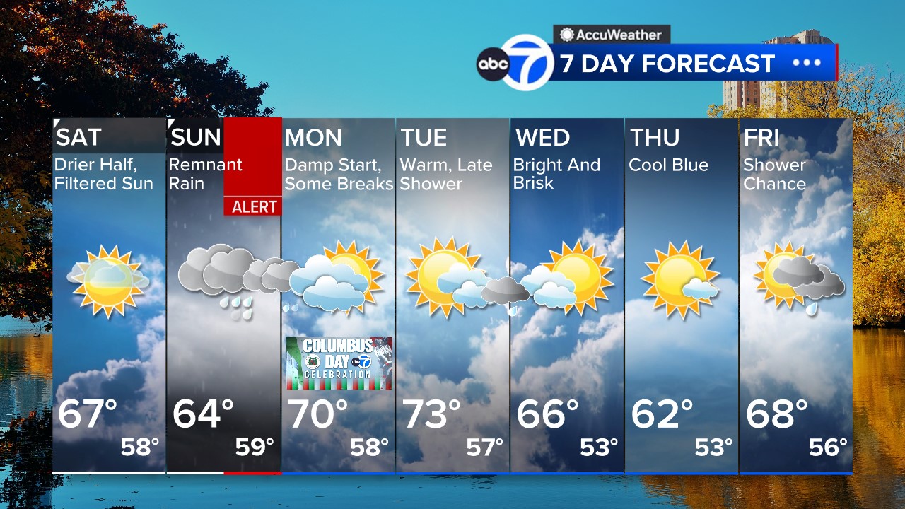
Saturday
Drier half, filtered sun. High 68
Sunday
AccuWeather Alert for PM remnant rain. High 64
Monday
Damp start, some breaks. High 69
Tuesday
Warm, late shower. High 73
Wednesday
Bright and brisk. High 66
Thursday
Cool blue. High 62
Friday
Shower chance. High 68
 Follow the Weather or Not podcast with Lee Goldberg
Please fill out the form below to submit weather photos and videos.
MORE ACCUWEATHER RESOURCES
Check AccuTrack Radar
Air Quality Tracker
NWS Advisories, Watches and Warnings
School closings and delays
For weather updates wherever you go, please download the AccuWeather app.
Follow chief meteorologist Lee Goldberg, Sam Champion, meteorologist Brittany Bell, meteorologist Jeff Smith, and meteorologist Dani Beckstrom on social media.
Copyright © 2026 WABC-TV. All Rights Reserved.