
The NBC5 First Warning Weather team is monitoring the potential for locally heavy lake-effect snow to impact the Thanksgiving Day holiday for some towns in Northern New York. On Thanksgiving itself, a persistent lake-effect snow band off Lake Ontario will continue to impact St. Lawrence County and the western Adirondacks. Under the most intense parts of the band, travelers may encounter slick roads, rapidly changing visibility, and localized higher snowfall totals.Vermont could see isolated afternoon snow showers, but overall impacts will be limited to places like Jay Peak and Mount Mansfield.By Friday, colder air behind a passing front will shift the lake-effect band farther south while opening the door to upslope snow on the northwestern slopes of the Adirondacks and Green Mountains. A few additional inches of accumulation are possible in the higher elevations, which may continue minor travel concerns into the start of the weekend.Conditions gradually calm by Saturday afternoon, with winds easing and snow showers tapering off. Want more local news? Download our NBC5 mobile app for iOS and Android. STAY WEATHER-AWAREFor the latest weather coverage for your area, click here. Stay updated with alerts in the myNBC5 app, which you can download here.For the best weather information and Vermont and northern New York’s Certified Most Accurate forecast, watch NBC5 News by streaming at this link.Don’t forget to follow NBC5 News on Facebook, X (formerly Twitter), and Instagram.Follow the NBC5 First Warning Weather team on social media:Chief Meteorologist Tyler Jankoski Facebook | X | InstagramMeteorologist Ben Frechette Facebook | X | InstagramMeteorologist Matt DiLoreto Facebook | XMeteorologist Andrew Grautski Facebook | XMeteorologist Marissa Vigevani Facebook | X
The NBC5 First Warning Weather team is monitoring the potential for locally heavy lake-effect snow to impact the Thanksgiving Day holiday for some towns in Northern New York.

NBC5 News
A winter storm watch has been issued for southern St. Lawrence County and several other counties downwind of Lake Ontario.
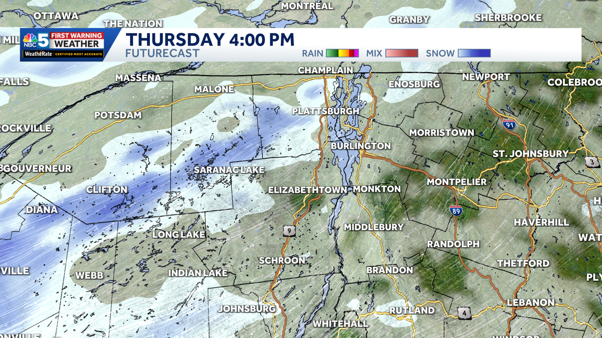
On Thanksgiving itself, a persistent lake-effect snow band off Lake Ontario will continue to impact St. Lawrence County and the western Adirondacks. Under the most intense parts of the band, travelers may encounter slick roads, rapidly changing visibility, and localized higher snowfall totals.

NBC5 News
Snowfall potential through the start of the weekend after Thanksgiving.
Vermont could see isolated afternoon snow showers, but overall impacts will be limited to places like Jay Peak and Mount Mansfield.

NBC5 News
Bitterly cold wind chills arrive through Friday and Saturday.
By Friday, colder air behind a passing front will shift the lake-effect band farther south while opening the door to upslope snow on the northwestern slopes of the Adirondacks and Green Mountains. A few additional inches of accumulation are possible in the higher elevations, which may continue minor travel concerns into the start of the weekend.
Conditions gradually calm by Saturday afternoon, with winds easing and snow showers tapering off.
Want more local news? Download our NBC5 mobile app for iOS and Android.
STAY WEATHER-AWARE
For the latest weather coverage for your area, click here. Stay updated with alerts in the myNBC5 app, which you can download here.
For the best weather information and Vermont and northern New York’s Certified Most Accurate forecast, watch NBC5 News by streaming at this link.
Don’t forget to follow NBC5 News on Facebook, X (formerly Twitter), and Instagram.
Follow the NBC5 First Warning Weather team on social media: