

NEW YORK (PIX11) — A highly amplified and moisture-loaded storm system will sweep into the Tri-State area on Tuesday, bringing a disruptive mix of heavy snow, sleet and rain.
This system will tap into strong jet stream energy and enough lingering cold air from New England to produce dynamic cooling, allowing for a burst of very heavy snowfall, even in areas that have marginal temperatures at the surface.
While the storm will track slightly too far north for New York City to see meaningful accumulation, many higher-elevation communities across New Jersey, New York and Connecticut are on track for a plowable snowfall.
Why this storm is complicated
This isn’t a classic cold-air-locked snowstorm. The outcome hinges on:
How quickly the storm arrives Tuesday morning
The strength of the mid-level jet
How efficiently colder air can be pulled down from New England
How long each zone holds onto snow before mixing occurs
A faster arrival favors more snow. A slower one opens the door for warmer air and earlier mixing.
NYC: Too warm for accumulating snow
Even though precipitation may start as wet snow or sleet in parts of the city, the storm track and warm boundary-layer temperatures prevent accumulation. New York City and the immediate coastal areas will see a cold, soaking rain, while snowfall happens mainly north and west of the city.
Timeline: Predawn through late Tuesday afternoon
The storm arrives before sunrise on Tuesday, with precipitation quickly overspreading the region.
Most locations outside the immediate coast may briefly start as snow or sleet, especially in elevated communities.
Key timing:
4 a.m. – 8 a.m.: Initial burst of snow/sleet inland; rain developing along the coast
8 a.m. – 1p.m.: Heaviest precipitation; widespread mixing; heavy snow band sets up N&W
1 p.m. – 5 p.m.: Storm pulls away; colder air wraps in; some areas flip back to wet snow
After 5 p.m.: Improving conditions for the evening commute
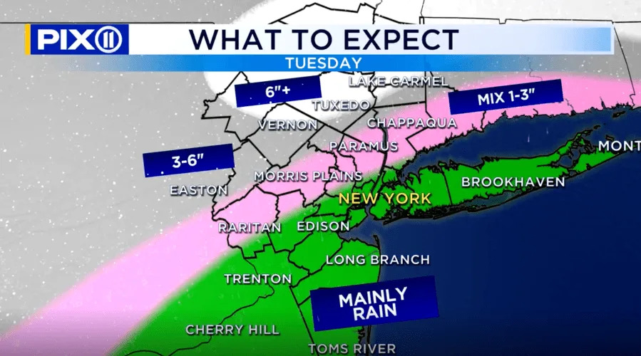
What to expect in New York on Tuesday, Dec. 2, 2025. (Credit: PIX11)
Heavy rain in Central NJ, NYC, Long Island
This region remains solidly in the warm sector, meaning no meaningful snow accumulation.
Surface temps and low-level air will be too warm to support snow beyond a brief early wintry mix.
Rain totals: 1–2 inches, heaviest toward eastern Long Island
Urban and poor-drainage flooding is possible with the heaviest downpours
Winds will increase slightly as the storm strengthens offshore
More: Latest News from Around the Tri-State
Mix of sleet, snow and rain in Lower Hudson Valley, Interior NJ, Southern Westchester, Southern CT
This transitional zone holds onto snow the longest before eventually flipping to sleet and rain. These areas will likely see:
A slushy early accumulation Tuesday morning
Highest totals in elevated terrain north of I-95 and north of the Tappan Zee Bridge
A potential wet snow ending as colder air wraps in late day
Travel Tuesday morning could be slick and messy, especially on untreated surfaces.
Heavy wet snow in Northwest NJ, Lower Hudson Valley north of I-84, Central CT
This is where the heaviest and most persistent snow occurs.
A strong band of lift will develop Tuesday morning into early afternoon, creating snowfall rates capable of outpacing marginal surface temperatures.
Expected totals:
3–6 inches of heavy, wet snow
Isolated pockets of 6” possible above 600 feet
Includes Sussex, Warren, Hunterdon Counties (NJ) and interior SE NY and CT
This snow will cling to trees and powerlines, leading to minor power outage potential.
Jackpot zone: Highest elevation north of I-84
This zone includes the highest terrain of the Catskills and interior Connecticut/New York. These areas sit firmly in the cold sector for most of the event, allowing for the most efficient accumulation.
Key locations:
Northern and high-elevation CT communities
Snow totals:
A few overachievers can’t be ruled out if the heavy band lingers
Confidence Note:
This zone is highly track-dependent. If the storm shifts southeast, colder air deepens and totals rise slightly. If the track shifts north, warmer air mixes in earlier and totals decrease.
Copyright 2025 Nexstar Media, Inc. All rights reserved. This material may not be published, broadcast, rewritten, or redistributed.
For the latest news, weather, sports, and streaming video, head to PIX11.