
Impact weather is expected Tuesday as a winter storm system brings the potential for widespread snow and slick travel conditions.The National Weather Service in Burlington has issued a winter storm watch for portions of southern Vermont and eastern Addison County.While snow totals will be lighter in the north, temperatures will be well below freezing. Slick roads should be expected even in areas with light accumulation.Steady snow will arrive during the morning commute, becoming most widespread by early afternoon. Light to moderate snow is expected in northern areas and will be heavy at times in southern Vermont.By Tuesday evening, a couple of inches are expected near Burlington and Plattsburgh, with at least 4 to 8 inches in southern areas.See the latest snow accumulation forecast:Northern New York and the Champlain ValleyNorthern VermontSouthern VermontView the extended forecast: STAY WEATHER-AWAREFor the latest weather coverage for your area, click here. Stay updated with alerts in the myNBC5 app, which you can download here.For the best weather information and Vermont and northern New York’s Certified Most Accurate forecast, watch NBC5 News by streaming at this link.Don’t forget to follow NBC5 News on Facebook, X (formerly Twitter), and Instagram.Follow the NBC5 First Warning Weather team on social media:Chief Meteorologist Tyler Jankoski Facebook | X | InstagramMeteorologist Ben Frechette Facebook | X | InstagramMeteorologist Matt DiLoreto Facebook | XMeteorologist Andrew Grautski Facebook | XMeteorologist Marissa Vigevani Facebook | X
SOUTH BURLINGTON, Vt. —
Impact weather is expected Tuesday as a winter storm system brings the potential for widespread snow and slick travel conditions.
The National Weather Service in Burlington has issued a winter storm watch for portions of southern Vermont and eastern Addison County.
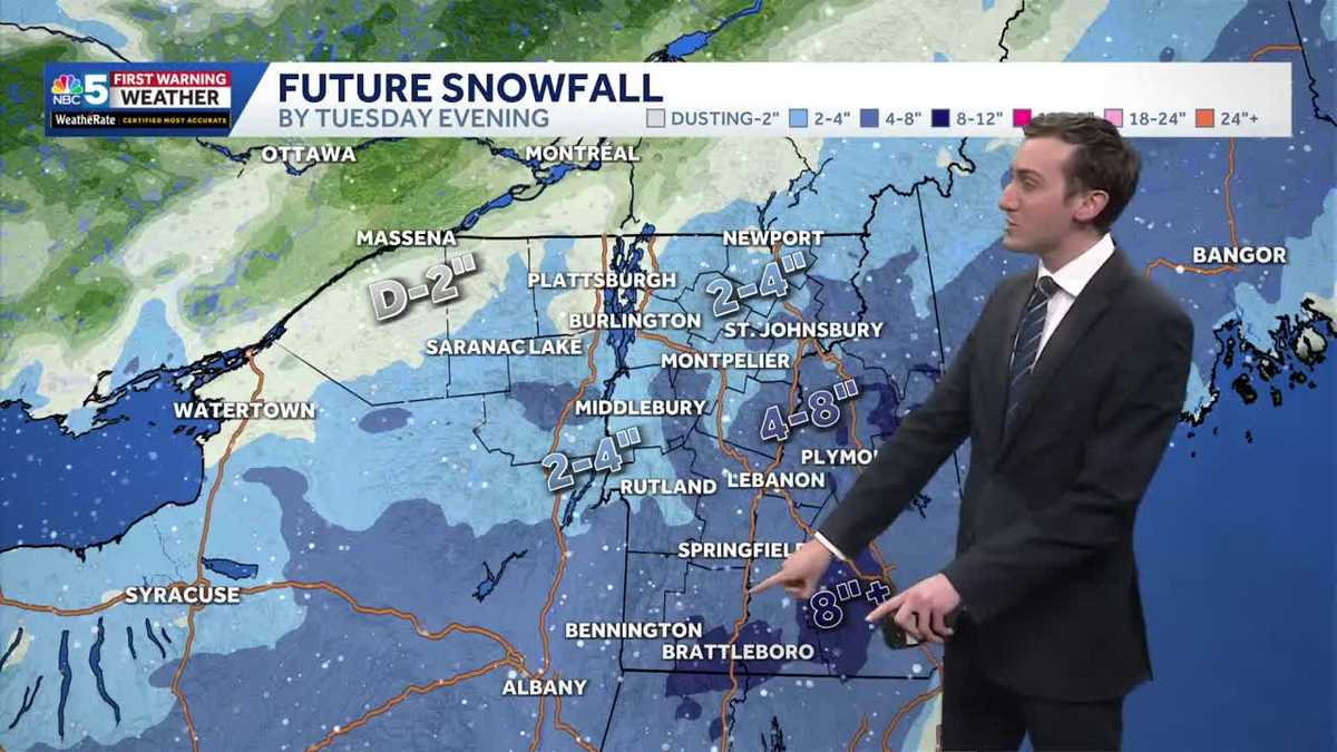
While snow totals will be lighter in the north, temperatures will be well below freezing. Slick roads should be expected even in areas with light accumulation.
Steady snow will arrive during the morning commute, becoming most widespread by early afternoon. Light to moderate snow is expected in northern areas and will be heavy at times in southern Vermont.
By Tuesday evening, a couple of inches are expected near Burlington and Plattsburgh, with at least 4 to 8 inches in southern areas.
See the latest snow accumulation forecast:
Northern New York and the Champlain Valley

Northern Vermont

Southern Vermont

View the extended forecast:

STAY WEATHER-AWARE
For the latest weather coverage for your area, click here. Stay updated with alerts in the myNBC5 app, which you can download here.
For the best weather information and Vermont and northern New York’s Certified Most Accurate forecast, watch NBC5 News by streaming at this link.
Don’t forget to follow NBC5 News on Facebook, X (formerly Twitter), and Instagram.
Follow the NBC5 First Warning Weather team on social media: