
Snow showers likely on Saturday and Sunday in Vermont, Northern New York
And Matt, as they’re getting ready to light the menorah, it’s going to be pretty cold out there come Sunday. Yes, it is going to be cold, and there may actually be *** little bit of snow falling as they’re lighting that on Sunday night, so. It adds to the holiday flair. Yes, it does, but the cold is going to be really entrenched there by Sunday, and we’ve got another bout of Arctic air coming in for Monday. Not that it’s already not cold out there, but it will get even colder for the start of next week. And we’ve still got some snow falling near the mountains. These mountain passes like 105 near Jay, totally snow covered right now as the snow continues to pound down. Even at Bolton Valley, you could see the flakes flying the folks on the ski lifts there enjoying the fresh powder. And on storm Tracker you can really see the moisture just hitting the mountains and this persistent snow is going all the way down toward Middlebury, certainly Chittenden County, eastern Franklin County into Lemoy County. The snow is coming down Jericho, Underhill, down to Starksboro and Bristol, and then down to Granville as well, and that will continue through the afternoon. If you’re in northern New York, you may see *** few flakes, but the best moisture is along the mountains in Vermont, and we do get *** bit of *** break in this snow action as we go forward tonight into very early tomorrow morning. There’s some high pressure that tries to build in, but this system is on its heels over Lake Superior right now. You can see another band of snow showers that comes through on Saturday afternoon. So really tomorrow afternoon with another round, another couple of inches possible. So you’ll see the mountain snow through 4 or 5 o’clock, then it tries to shut down tonight. So tomorrow morning we start off dry. There could be *** few peaks of sunshine, but overall it’s *** cloudy Saturday. And then here come the snow showers by lunchtime filling in across the region. There may actually be some heavier bursts in there, some heavier snow squalls tomorrow late afternoon. This is 3 o’clock coming through Saranac Lake. It may come through the Champlain Valley 56 o’clock tomorrow afternoon. So just be aware of that. Things may quickly get coated up. Visibility drops quickly. And then on Sunday, We may have *** little more sunshine mixing in with the clouds, but we still have some lingering moisture left over, and that means that on and off snow showers will continue in the typical spots during the day on Sunday. There may actually be some blocked flow, which means that the moisture hits the mountains and backs up into Chittenden County and Franklin County on Sunday evening, so additional accumulation is possible even in the valley locations. With that kind of setup as we go forward, so putting it all together, it’s *** widespread dusting to 2 inches across the region when you add it all up both days. Now it’s not going to be snowing at any given time. It’s just these on and off bouts of snow. So at any point this weekend you could get hit with that. You could see some locally higher amounts south of Malone, 2 to 4 inches from Duane to Star Lake, of course, Mount Marcy. And the high peaks region always does *** little better there, dusting to 2 for the Champlain Valley, but notice those enhanced totals in Chittenden County. We could be talking 2 to 4 inches there because of that blocked flow. 4 to 8 plus for the summits from Jay down to Mansfield, 2 to 4 for *** good chunk of the Northeast Kingdom, and that snow even goes down south, even into the upper valley, dusting to 2 there, dusting to 2 for Rutland. And then down the spine of the Green Mountains as well. So *** bit of *** snowy weekend, but it’s not like we’re talking about *** lot of snow. It’ll just put *** refresher on the snowpack and then look at the cold that comes in behind the snow on Sunday. We’re talking about temperatures back down into the single digits overnight with highs in the teens on Monday. And then look at that. We have *** warm up in the cards, very brief. Late next week, temperatures near 40 with *** bit of rain and wintry mix possible.
NBC5 First Warning Meteorologist
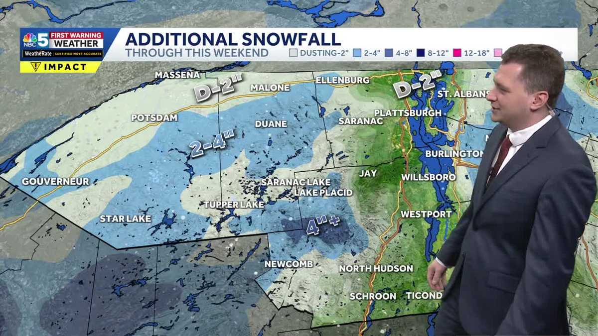
The NBC5 First Warning Weather team is tracking sporadic snow showers on Saturday and Sunday across both Vermont and Northern New York that could add up to several more inches of powder regionwide.Saturday will start off cloudy before a band of snow showers moves in from New York around lunchtime. Snow showers will continue in the afternoon, with some heavier snow squalls possible in New York and the Champlain Valley.Sunday will have some sun mixing in, but lingering moisture continues to bring on and off snow showers throughout the day.Want more local news? Download our NBC5 mobile app for iOS and Android.Snow totalsOverall, you should expect a widespread dusting to 2 inches of snow in most areas, with parts of Northern New York seeing more in the 2 to 4 inch range for the entire weekend.The high elevations of the Green Mountains will see between 4 to 8 inches of snow, even south into Bennington County. Looking to next week, you can expect more cold and windy conditions ahead of a brief warm-up that will bring rain and a wintry mix on Thursday.STAY WEATHER-AWAREFor the latest weather coverage for your area, click here. Stay updated with alerts in the myNBC5 app, which you can download here.For the best weather information and Vermont and northern New York’s Certified Most Accurate forecast, watch NBC5 News by streaming at this link.Don’t forget to follow NBC5 News on Facebook, X (formerly Twitter), and Instagram.Follow the NBC5 First Warning Weather team on social media:Chief Meteorologist Tyler Jankoski Facebook | X | InstagramMeteorologist Ben Frechette Facebook | X | InstagramMeteorologist Matt DiLoreto Facebook | XMeteorologist Andrew Grautski Facebook | XMeteorologist Marissa Vigevani Facebook | X
SOUTH BURLINGTON, Vt. —
The NBC5 First Warning Weather team is tracking sporadic snow showers on Saturday and Sunday across both Vermont and Northern New York that could add up to several more inches of powder regionwide.
Saturday will start off cloudy before a band of snow showers moves in from New York around lunchtime. Snow showers will continue in the afternoon, with some heavier snow squalls possible in New York and the Champlain Valley.
Sunday will have some sun mixing in, but lingering moisture continues to bring on and off snow showers throughout the day.
Want more local news? Download our NBC5 mobile app for iOS and Android.
Snow totals
Overall, you should expect a widespread dusting to 2 inches of snow in most areas, with parts of Northern New York seeing more in the 2 to 4 inch range for the entire weekend.
The high elevations of the Green Mountains will see between 4 to 8 inches of snow, even south into Bennington County.
Looking to next week, you can expect more cold and windy conditions ahead of a brief warm-up that will bring rain and a wintry mix on Thursday.
This content is imported from Facebook.
You may be able to find the same content in another format, or you may be able to find more information, at their web site.
STAY WEATHER-AWARE
For the latest weather coverage for your area, click here. Stay updated with alerts in the myNBC5 app, which you can download here.
For the best weather information and Vermont and northern New York’s Certified Most Accurate forecast, watch NBC5 News by streaming at this link.
Don’t forget to follow NBC5 News on Facebook, X (formerly Twitter), and Instagram.
Follow the NBC5 First Warning Weather team on social media: