
NBC5 meteorologists are tracking light to moderate snow Tuesday with widespread slippery travel expected, especially during the evening commute. Storm TimelineAside from spotty light snow showers, quiet weather continues through the Tuesday morning commute with no weather-related impacts expected.Snow will arrive southwest to northeast from mid-morning to early afternoon Tuesday, beginning first in southern Vermont and northern New York.A late-morning arrival is likely in the Champlain Valley through the Connecticut River Valley, followed by the Northeast Kingdom in the early afternoon. Steady snow continues regionwide through the evening, becoming focused along the mountain spines overnight into early Wednesday. Lingering snow showers are possible in the wide valleys during the morning commute.Mountain snow slowly tapers through Wednesday.Travel ImpactsTemperatures stay near or below freezing through the entire event, leading to slick and snow-covered roads through Tuesday afternoon. The worst road conditions are expected Tuesday evening, with lingering snow showers and steadier mountain snow lasting into Wednesday morning.Conditions will largely improve by Wednesday evening.Snow TotalsA widespread 2 to 4 inches of snow will fall by Wednesday morning, with higher amounts above 1,000 feet elevation and throughout the mountain towns. See region-by-region snowfall maps below.Christmas and BeyondChristmas Day is much quieter! Mostly cloudy with an occasional snow shower, highs around 30 degrees. A period of unsettled weather with mixed showers is possible Friday through the following weekend. NBC5 meteorologists will have more on that system in the coming days.
BURLINGTON, Vt. —
NBC5 meteorologists are tracking light to moderate snow Tuesday with widespread slippery travel expected, especially during the evening commute.
Storm Timeline
Aside from spotty light snow showers, quiet weather continues through the Tuesday morning commute with no weather-related impacts expected.
")
NBC5 News
Forecast snow arrival time through Tuesday morning and early afternoon.
Snow will arrive southwest to northeast from mid-morning to early afternoon Tuesday, beginning first in southern Vermont and northern New York.
A late-morning arrival is likely in the Champlain Valley through the Connecticut River Valley, followed by the Northeast Kingdom in the early afternoon.

Hearst Owned
The latest hour-by-hour storm timeline on FutureCast.
Steady snow continues regionwide through the evening, becoming focused along the mountain spines overnight into early Wednesday. Lingering snow showers are possible in the wide valleys during the morning commute.
Mountain snow slowly tapers through Wednesday.
Travel Impacts
")
NBC5 News
Travel impacts through Tuesday into Wednesday.
Temperatures stay near or below freezing through the entire event, leading to slick and snow-covered roads through Tuesday afternoon.
The worst road conditions are expected Tuesday evening, with lingering snow showers and steadier mountain snow lasting into Wednesday morning.
Conditions will largely improve by Wednesday evening.
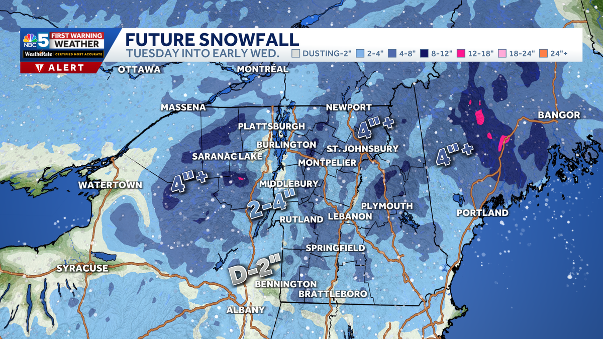
Snow Totals
A widespread 2 to 4 inches of snow will fall by Wednesday morning, with higher amounts above 1,000 feet elevation and throughout the mountain towns.
See region-by-region snowfall maps below.
")
NBC5 News
Forecast snow totals in Northern New York.
")
NBC5 News
Forecast snow totals in Northern Vermont.
")
NBC5 News
Forecast snow totals in Southern Vermont.
Christmas and Beyond

Hearst Owned
Our latest 10-day forecast.
Christmas Day is much quieter! Mostly cloudy with an occasional snow shower, highs around 30 degrees.
A period of unsettled weather with mixed showers is possible Friday through the following weekend. NBC5 meteorologists will have more on that system in the coming days.