
NBC5 meteorologists are tracking light to moderate snow Tuesday with widespread slippery travel expected, especially during the evening commute. New Tuesday Morning: Winter weather advisories have been issued by the National Weather Service for the higher elevations of northern New York and Vermont, where the highest overall totals are expected. Alerts remain in effect through Wednesday morning. Storm TimelineAside from spotty light snow showers, quiet weather continues through the Tuesday morning commute with no weather-related impacts expected.Snow will arrive southwest to northeast from mid-morning to early afternoon Tuesday, beginning first in southern Vermont and Northern New York.A late-morning arrival is likely in the Champlain Valley through the Connecticut River Valley, followed by the Northeast Kingdom in the early afternoon. Steady snow continues regionwide through the evening, becoming focused along the mountain spines overnight into early Wednesday. Lingering snow showers are possible in the wide valleys during the morning commute.Mountain snow slowly tapers through Wednesday.Travel ImpactsTemperatures stay near or below freezing through the entire event, leading to slick and snow-covered roads through Tuesday afternoon. The worst road conditions are expected Tuesday evening, with lingering snow showers and steadier mountain snow lasting into Wednesday morning.Conditions will largely improve by Wednesday evening. Snow TotalsA widespread 2 to 4 inches of snow will fall by Wednesday morning, with higher amounts above 1,000 feet elevation and throughout the mountain towns. See region-by-region snowfall maps below.Northern New York:Northern Vermont and New Hampshire:Southern Vermont and New Hampshire:Christmas and BeyondChristmas Day is much quieter! Mostly cloudy with an occasional snow shower, highs around 30 degrees. Bitter cold is expected on Friday, with a wintry mix possible by Sunday. NBC5 meteorologists will have more on that system in the coming days. Want more local news? Download our NBC5 mobile app for iOS and Android. STAY WEATHER-AWAREFor the latest weather coverage for your area, click here. Stay updated with alerts in the myNBC5 app, which you can download here.For the best weather information and Vermont and northern New York’s Certified Most Accurate forecast, watch NBC5 News by streaming at this link.Don’t forget to follow NBC5 News on Facebook, X (formerly Twitter), and Instagram.Follow the NBC5 First Warning Weather team on social media:Chief Meteorologist Tyler Jankoski Facebook | X | InstagramMeteorologist Ben Frechette Facebook | X | InstagramMeteorologist Matt DiLoreto Facebook | XMeteorologist Andrew Grautski Facebook | XMeteorologist Marissa Vigevani Facebook | X
NBC5 meteorologists are tracking light to moderate snow Tuesday with widespread slippery travel expected, especially during the evening commute.
New Tuesday Morning: Winter weather advisories have been issued by the National Weather Service for the higher elevations of northern New York and Vermont, where the highest overall totals are expected. Alerts remain in effect through Wednesday morning.
")
NBC5 News
Winter weather advisories in effect through Wednesday at 7 AM.
Storm Timeline
Aside from spotty light snow showers, quiet weather continues through the Tuesday morning commute with no weather-related impacts expected.
")
NBC5 News
Forecast snow arrival time through Tuesday morning and early afternoon.
Snow will arrive southwest to northeast from mid-morning to early afternoon Tuesday, beginning first in southern Vermont and Northern New York.
A late-morning arrival is likely in the Champlain Valley through the Connecticut River Valley, followed by the Northeast Kingdom in the early afternoon.
Steady snow continues regionwide through the evening, becoming focused along the mountain spines overnight into early Wednesday. Lingering snow showers are possible in the wide valleys during the morning commute.
Mountain snow slowly tapers through Wednesday.
Travel Impacts

Temperatures stay near or below freezing through the entire event, leading to slick and snow-covered roads through Tuesday afternoon.
The worst road conditions are expected Tuesday evening, with lingering snow showers and steadier mountain snow lasting into Wednesday morning.
Conditions will largely improve by Wednesday evening.
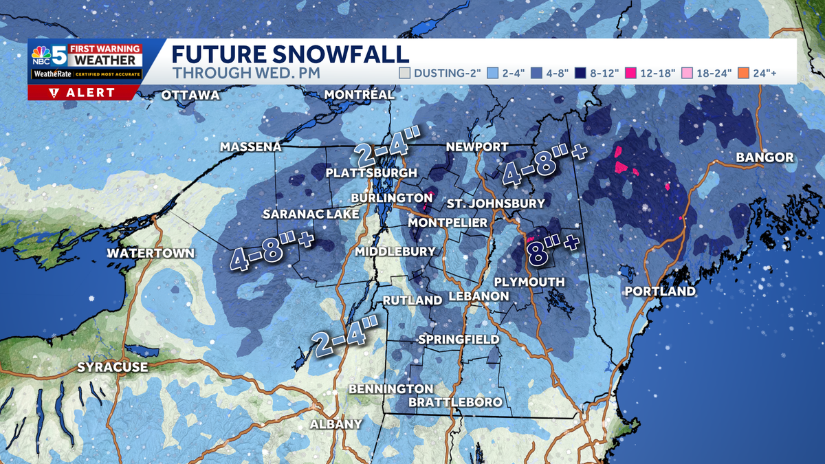
Snow Totals
A widespread 2 to 4 inches of snow will fall by Wednesday morning, with higher amounts above 1,000 feet elevation and throughout the mountain towns.
See region-by-region snowfall maps below.
Northern New York:
")
Northern Vermont and New Hampshire:
")
Southern Vermont and New Hampshire:

Christmas and Beyond

Hearst Owned
Our latest 10-day forecast.
Christmas Day is much quieter! Mostly cloudy with an occasional snow shower, highs around 30 degrees.
Bitter cold is expected on Friday, with a wintry mix possible by Sunday. NBC5 meteorologists will have more on that system in the coming days.
Want more local news? Download our NBC5 mobile app for iOS and Android.
STAY WEATHER-AWARE
For the latest weather coverage for your area, click here. Stay updated with alerts in the myNBC5 app, which you can download here.
For the best weather information and Vermont and northern New York’s Certified Most Accurate forecast, watch NBC5 News by streaming at this link.
Don’t forget to follow NBC5 News on Facebook, X (formerly Twitter), and Instagram.
Follow the NBC5 First Warning Weather team on social media: