
After months of forecasts predicting a return, La Niña conditions emerged in September. But what does this mean for winter weather in New York?
To understand the impact, one must first understand what La Niña actually is.
The El Niño-Southern Oscillation cycle, otherwise known as the ENSO cycle, is a recurring climate pattern pertaining to changes in the water temperatures in the central and eastern tropical Pacific Ocean, according to the National Weather Service.
Over time, the sea surface temperatures tend to either warm up or cool down. This is what the weather service refers to as the ENSO cycle.
Cycle-neutral conditions are present when water temperatures are normal, neither below nor above-average. In this stage, seasonal conditions typically prevail and the phenomenon doesn’t play a major role in determining weather conditions.
La Niña is the cold phase of this cycle while El Niño is the warm phase. During La Niña, cold water conditions are prevalent and trade winds enhanced, directing warm water toward Asia, ultimately cooling waters off the West Coast, as detailed by the National Oceanic and Atmospheric Administration.
According to an Oct. 9 report by the National Weather Service’s Climate Prediction Center, the cycle is now in the La Niña phase. These La Niña conditions are forecast to persist through sometime between December and February. However, there is a 55% chance that El Niño-Southern Oscillation-neutral conditions return sometime between January and March, as indicated by the Climate Prediction Center.
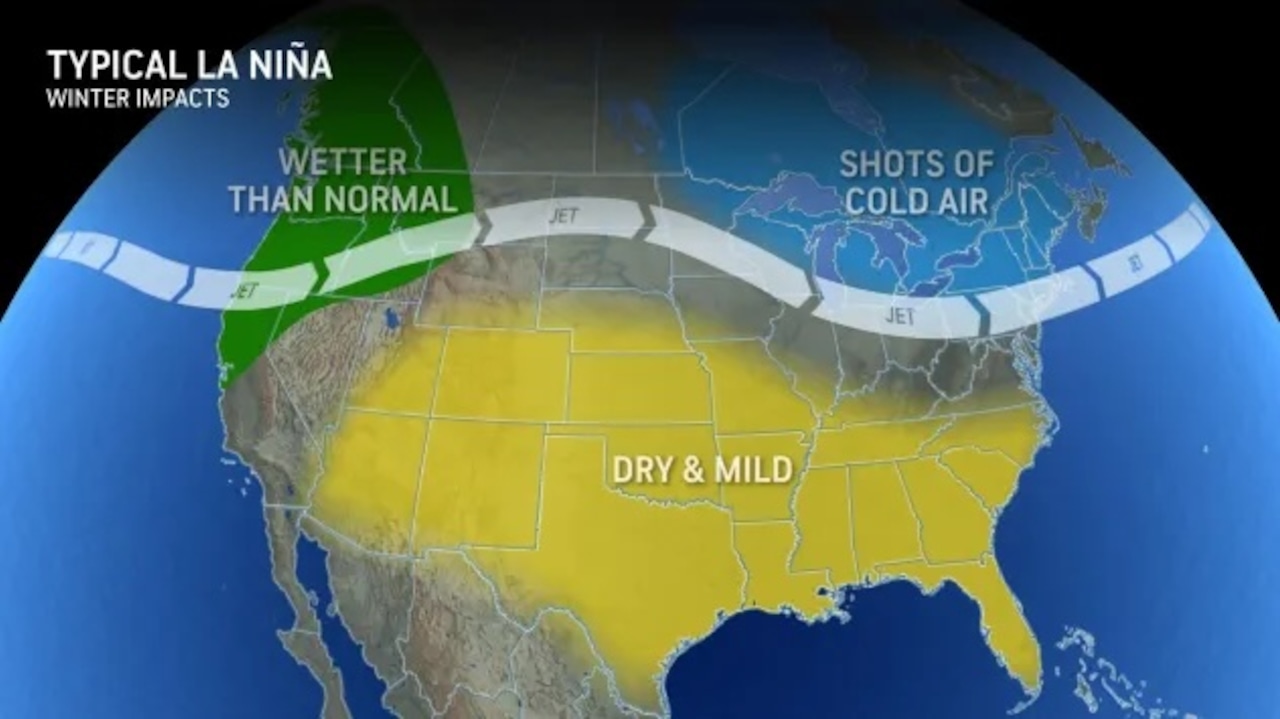
Typically, the shifts in ocean temperatures associated with the ENSO cycle can modify the jet streams and subsequently influence weather patterns around the world, as noted by AccuWeather.
In a La Niña winter, two storm tracks usually converge in the Northwest and western Canada, resulting in colder-than-average temperatures and above-normal precipitation, according to AccuWeather Lead Long-Range Forecaster Paul Pastelok. In the east, the northern stem of the jet stream usually sees fast-moving, weakened storms, which could mean near or below-average snowfall amounts and seasonal temperatures for that region.
As for other parts of the country, as detailed by the National Ocean Service, during a La Niña year, the winter temperatures are warmer than normal in the South and cooler than normal in the North.
Although La Niña has emerged, the Climate Prediction Center said that this phase is expected to “remain weak.” As such, it is less likely to produce conventional impacts.
If you purchase a product or register for an account through a link on our site, we may receive compensation. By using this site, you consent to our User Agreement and agree that your clicks, interactions, and personal information may be collected, recorded, and/or stored by us and social media and other third-party partners in accordance with our Privacy Policy.