The bulk of the storm has passed, but snow continued falling on the tri-state well into Saturday morning.
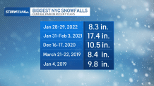
The post-Christmas storm made a mess of the roads and skies after dropping several inches of snow across the metro region. In Central Park, New York City recorded 4.3 inches of snow by 7 a.m., that’s the most since early January when a storm brought over 8 inches.
The major weather alerts were expiring through the morning as the last remnants of the storm headed out. The main threat now becomes the cold.
New York City issued a Code Blue starting 4 p.m. Saturday and lasting into Sunday morning. Officials advised anyone needing assistance to call 311.
Temperatures were in the mid 20s for most of the area around 9 a.m. and were not expected to tick up much higher than that throughout the day. Below freezing temps could make snow-covered roads and sidewalks slick. Caution is urged while traveling the rest of the weekend.
Speaking of travel, millions are expected to hit the road and skies this weekend to travel home after the Christmas holiday. At least 1,500 flights were canceled from Friday night into Saturday, according to flight-tracking service FlightAware.
Newark Liberty International Airport, John F. Kennedy International Airport and LaGuardia Airport posted snow warnings on the social media platform X on Friday, cautioning that weather conditions could cause flight disruptions.
Ahead of the storm, New York Gov. Kathy Hochul declared a state of emergency for more than half of the state. Acting New Jersey Gov. Tahesha Way declared a state of emergency for all of New Jersey, “due to a severe winter storm causing dangerous weather conditions, including heavy snow, sleet, and freezing rain.”
“This storm will cause dangerous road conditions and impact holiday travel,” Way said in a statement. “We are urging travelers to avoid travel during the storm and allow crews to tend to the roads. Drivers should plan their travel accordingly, monitor conditions and road closures, and follow all safety protocols.”
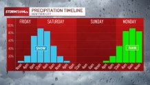
Another system – warmer with all rain – will move through Sunday night.
The second system moving through over the weekend, the Sunday evening rain event, will melt some of the snow on the ground and could cause isolated flooding and travel headaches into Monday.
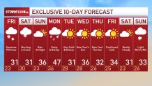
After this weekend, very cold air moves in as we close out 2025 and say hello to 2026. Bundle up!