

NEW YORK CITY (PIX11) — A loaded long-range pattern is taking shape as we head toward Halloween week, with early signals suggesting the atmosphere could be primed for more East Coast storm development between Oct. 29 and Nov. 1.
PIX 11 Meteorologists said this setup, driven by blocking over Hudson Bay and a building ridge over the northern Rockies, is the kind of configuration that often fuels powerful coastal systems.
“In winter, this would be the exact look you’d want for a major snowstorm,” Mike Masco said.
“Even in late October, it can still bring strong, wind-driven coastal events similar to what was experienced a week ago.”
Pattern breakdown
Close to Halloween, forecast models show a positive height rise east of Hudson Bay, a sign of developing atmospheric blocking. At the same time, a ridge forming over Montana is redirecting the jet stream southward into the southeastern United States.
That jet configuration often funnels energy and moisture into the Gulf and Atlantic corridors—where storms can then lift up the East Coast.
NYC forecast and PIX11’s Weather Center
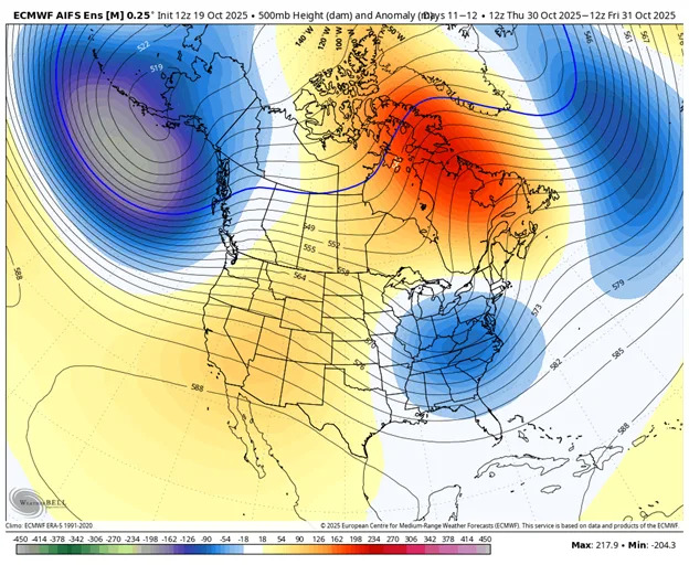
Long-range models highlight an emerging block near Hudson Bay, a signal that often precedes East Coast storm development. (Credit: Weatherbell.com)
Storm potential and timing
The most active window appears to be Oct. 29 through Nov. 1, when the upper-level energy converges near the eastern U.S. coastline. If that alignment holds, forecasters say it could bring:
Heavy rain and gusty winds along the I-95 corridor
Coastal flooding and erosion along NJ, Long Island, and New England
A chillier air mass filtered in behind the system
This is not a storm forecast—yet—but a pattern signal, and one that’s growing more organized with each model run.
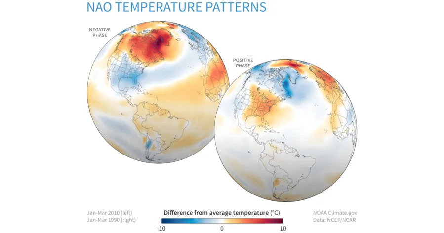
A jet stream dip into the Southeast sets up the classic pattern for East Coast storm formation when the North Atlantic oscillation turns negative. (Credit: NOAA)
EURO AI Model in focus
The projection comes from the European AI (EURO-AI) model, a new experimental system trained on decades of global weather data. The EURO-AI has posted several wins this fall in identifying long-range pattern shifts 7–10 days out.
Masco plans to test its performance through Halloween week by comparing its pattern evolution to traditional EURO and GFS model runs.
“It’s held up surprisingly well at range,” Masco said. “Now we’ll see if it can sniff out another big pattern change before the others catch on.”
Copyright 2025 Nexstar Media, Inc. All rights reserved. This material may not be published, broadcast, rewritten, or redistributed.
For the latest news, weather, sports, and streaming video, head to PIX11.