
NBC5 meteorologists are tracking a wintry system set to arrive Saturday night with widespread snow for some (and an icy mix for others) in Vermont and northern New York. Additional locally heavy snow showers are possible Sunday afternoon.All of the daylight hours on Saturday are dry — it’s the pick of the weekend with temperatures in the mid 30s and mostly cloudy skies.After sunset, mixed showers spread into southern Vermont and parts of the North Country as early as 7 p.m. Widespread moderate to heavy snow will peak around midnight Sunday, especially across northern Vermont and northern New York. An icy mix will linger in southern Vermont.Snowy roads are likely Sunday morning as steady snow tapers into the mountains. Additional snow showers, and perhaps a couple squalls, will develop Sunday afternoonIce accumulations will stay under a tenth of an inch, primarily along the southern Green Mountains and within the colder hollows of the Adirondacks.Snow accumulations will be similar to the past several systems — generally 2 to 4 inches in in the immediate Champlain Valley, with 4-6″ amounts in the higher elevations of north/central Vermont and through the North Country. Less snow is expected in southern Vermont due to mixing.Temperatures stay in the 30s through the middle of next week, before another round of sustained cold moves in by Thursday.Want more local news? Download our NBC5 mobile app for iOS and Android.STAY WEATHER-AWAREFor the latest weather coverage for your area, click here. Stay updated with alerts in the myNBC5 app, which you can download here.For the best weather information and Vermont and northern New York’s Certified Most Accurate forecast, watch NBC5 News by streaming at this link.Don’t forget to follow NBC5 News on Facebook, X (formerly Twitter), and Instagram.Follow the NBC5 First Warning Weather team on social media:Chief Meteorologist Tyler Jankoski Facebook | X | InstagramMeteorologist Ben Frechette Facebook | X | InstagramMeteorologist Matt DiLoreto Facebook | XMeteorologist Andrew Grautski Facebook | XMeteorologist Marissa Vigevani Facebook | X
SOUTH BURLINGTON, Vt. —
NBC5 meteorologists are tracking a wintry system set to arrive Saturday night with widespread snow for some (and an icy mix for others) in Vermont and northern New York. Additional locally heavy snow showers are possible Sunday afternoon.

Hearst Owned
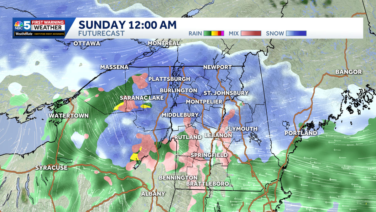
The latest run of FutureCast.
All of the daylight hours on Saturday are dry — it’s the pick of the weekend with temperatures in the mid 30s and mostly cloudy skies.
After sunset, mixed showers spread into southern Vermont and parts of the North Country as early as 7 p.m.
Widespread moderate to heavy snow will peak around midnight Sunday, especially across northern Vermont and northern New York. An icy mix will linger in southern Vermont.
Snowy roads are likely Sunday morning as steady snow tapers into the mountains. Additional snow showers, and perhaps a couple squalls, will develop Sunday afternoon

NBC5 News
Forecast ice accumulations through Sunday morning.
Ice accumulations will stay under a tenth of an inch, primarily along the southern Green Mountains and within the colder hollows of the Adirondacks.

NBC5 News
Forecast snow accumulations from Saturday night through Sunday afternoon.
Snow accumulations will be similar to the past several systems — generally 2 to 4 inches in in the immediate Champlain Valley, with 4-6″ amounts in the higher elevations of north/central Vermont and through the North Country. Less snow is expected in southern Vermont due to mixing.

Hearst Owned
Our latest extended forecast.
Temperatures stay in the 30s through the middle of next week, before another round of sustained cold moves in by Thursday.
Want more local news? Download our NBC5 mobile app for iOS and Android.
STAY WEATHER-AWARE
For the latest weather coverage for your area, click here. Stay updated with alerts in the myNBC5 app, which you can download here.
For the best weather information and Vermont and northern New York’s Certified Most Accurate forecast, watch NBC5 News by streaming at this link.
Don’t forget to follow NBC5 News on Facebook, X (formerly Twitter), and Instagram.
Follow the NBC5 First Warning Weather team on social media: