

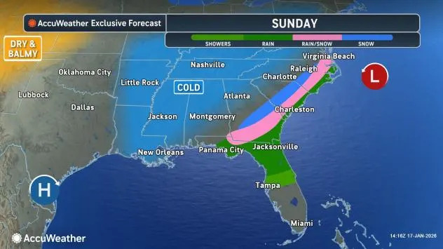
A storm forecast to strengthen and run northeastward along the Atlantic Coast from late Saturday night to Sunday night will spread a swath of accumulating snow, causing travel problems. While only a small amount of snow is expected for the winter-sensitive Southeast, moderate to heavy snowfall is likely for coastal areas of the Northeast.
Snow to create slushy, slippery conditions in Southeast
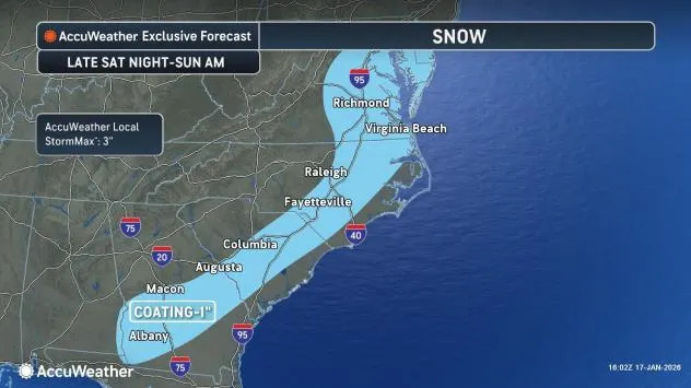
Temperatures near or above the freezing mark around the time of the snow from late Saturday night to Sunday will limit accumulations to a general coating to 1 inch from southern Georgia to eastern Virginia and the lower part of Delmarva. There will be some pockets where a couple of inches of snow may fall, mainly on non-paved surfaces in this zone with an AccuWeather Local StormMax™ of 3 inches.
AccuWeather.com
A separate pocket of snow will also develop over the southern Appalachians during Saturday night with a coating to 1-2 inches of snow in some areas. A mixture of rain and wet snow will occur in the western part of the Florida Panhandle and the southeastern corner of Alabama, with little or no accumulation, as the ground will be warm.
Southeastern United States cities that have the potential to pick up a coating to 1 inch of snow, mainly on non-paved surfaces, include Macon, Georgia, Columbia, South Carolina, Raleigh, North Carolina, and Norfolk, Virginia.
AccuWeather.com
“Winter weather can have major travel impacts in the Southeast because the region has fewer plow trucks, salt supplies and treatment resources than northern states,” AccuWeather Senior Meteorologist Dan Pydynowski said.
“Even where roads look wet, temperatures dropping below freezing can turn those surfaces icy, creating dangerous driving conditions with little warning,” Pydynowski said. “Drivers should slow down and use extra caution, especially on bridges and overpasses, which tend to freeze first because cold air flows above and below the roadway.”
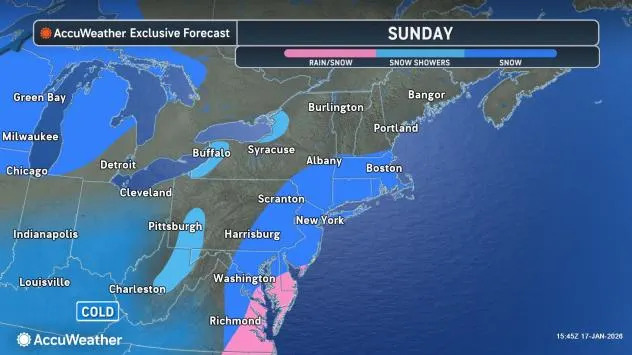
Portions of coastal Northeast brace for several inches of snow
As the storm continues to move along, snow will expand eastward from the mountains of West Virginia and western Maryland and northward along the coast of the mid-Atlantic to southeastern and central New England on Sunday.
AccuWeather.com
Temperatures will be close to or just above the freezing mark along the coast. This will tend to cause some of the snow to melt as it falls on the streets and highways for a time. However, where the snow picks up in intensity and where the temperature is slightly lower outside of the most urban areas along Interstate 95, paved and concrete surfaces can become slushy and snow covered.
Have the app? Unlock AccuWeather Alerts™ with Premium+
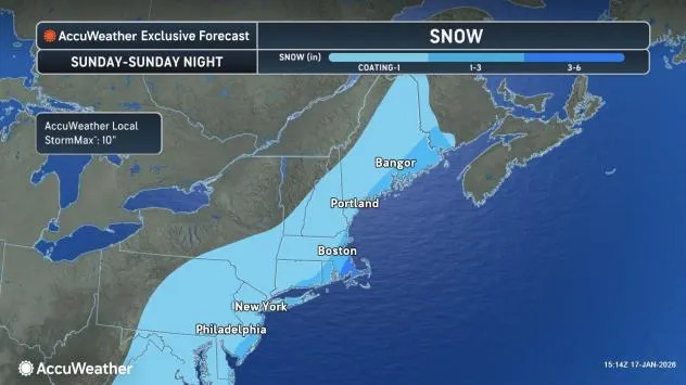
Cities in the Northeast that are forecast to pick up a coating to an inch of snow include Washington, D.C., Baltimore, and Manhattan. Boston and Philadelphia can expect to pick up 1-3 inches of snow. Areas along the Delaware and New Jersey coasts, as well as central Long Island, New York, and southeastern Maine, will pick up 1-3 inches, with 3-6 inches expected in southeastern Massachusetts.
AccuWeather.com
There is potential for heavier snow to develop and expand farther inland if the storm strengthens to its full potential while slowing just a bit.
Motorists and airline passengers in the storm-affected areas of the Northeast should expect delays from Sunday to Sunday night in the Northeast. Deicing operations may be needed, even where snow is mainly melting on runways.
Want next-level safety, ad-free? Unlock advanced, hyperlocal severe weather alerts when you subscribe to Premium+ on the AccuWeather app. AccuWeather Alerts™ are prompted by our expert meteorologists who monitor and analyze dangerous weather risks 24/7 to keep you and your family safer.