
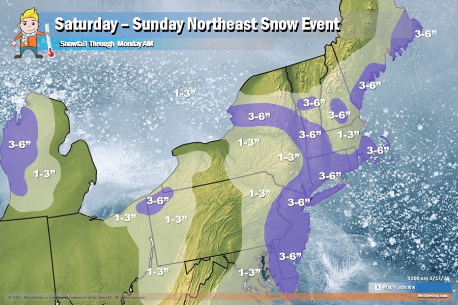
 Snowfall totals for the northeast through to Monday morning from two separate snow events. Image: Weatherboy
Two systems will bring two distinct rounds of snowfall to portions of the northeast this weekend, ultimately delivering plowable snow for a significant stretch of the heavily traveled I-95 corridor in the northeast; 3″ or more of snow is also in the forecast for places like Philadelphia and New York City too.
Periods of snow are expected to continue through this afternoon, primarily northwest of I-95. Snow amounts will be highest near and north of I-78. Generally 1-3″ of snow will fall from this first system, with an isolated 4″ possible in the highest terrain of Pennsylvania and New York state. Once snow ends in this area tonight, the attention will shift south.
A coastal low is forecast to slide offshore on Sunday, bringing additional snow, mainly to areas along and south/east of I-95. The highest snow amounts will be concentrated near the coast. Right now, it appears that an area of low pressure will develops off the coast of the Outer Banks of North Carolina tonight and lift northeast. It now looks like this low will pass close enough to the coast to bring snow to the northern Mid Atlantic and southeast New England, mainly along and south and east of the I-95 corridor. Snowfall from this second system won’t spread much into northeastern Pennsylvania or upstate New York, but should fall at a decent clip in southeast New England, especially over and around the Cape Cod area. Snow from this second event will develop Sunday morning and continue throughout the day into Sunday night.
By the time this second storm wraps up, it’ll drop 2-4″ of snow, with some isolated heavier amounts, across portions of Delaware, New Jersey, Long Island, Connecticut, Rhode Island, and southeastern Massachussetts. This includes cities like Philadelphia and New York City which should see around 3″ of snow, with a little more or less possible in the suburbs around those cities. This won’t be a heavy snowfall, but it should be a plowable event for some heavily populated portions of the I-95 area.
Once the snow wraps up, a prolonged period of below normal temperatures are expected this upcoming week, with single digit and below zero wind chills possible
both Monday Night and Tuesday Night.