
BURLINGTON, Vt. (WCAX) – Vermont, New York, and the Upper Valley are bracing for its biggest snowfall since February of last year. Snow begins falling late Sunday evening and continues through Monday.
Winter Storm Watches and Warnings are in effect ahead of the system’s arrival. Winter Storm Warnings are in effect from 1 p.m Sunday to 1 a.m. Tuesday for Southern and Central Vermont, while Winter Storm Watches are in effect for the rest of the viewing area in Northern Vermont and the North Country.
 Moderate to heavy snowfall expected late Sunday into Monday(Gunnar Consol)
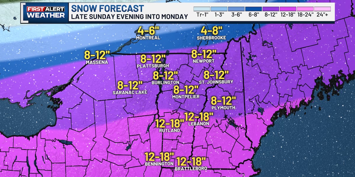
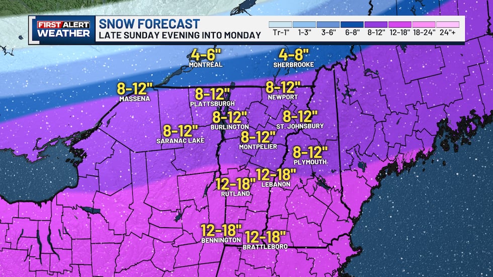
Moderate to heavy snowfall is expected. Widespread 8-12″ expected in the northern half of the viewing area, and widespread 12-18″ expected in the southern half of the viewing area.
Modifications to the forecast are anticipated with 2 days left until the storm arrives. The most likely changes to the forecast will be the snowfall totals for the northern tier of the viewing area. There is expected to be a sharp cutoff near the Canadian border and depending on how far north the precipitation field of this winter storms goes will depend on who sees a lot and who sees just a little snowfall.
Impacts like difficult travel are expected, however, since air temperatures will be so cold this will be a dry fluffy snow. The snow texture may even fall more like pixie dust which means snow removal would be easier than a wet and heavy snow. With the snow expected to be light and airy, snow accumulations on the roadways themselves should be minimal as road traffic kicks the snow up and causes it to blow away. Snow removal with a leaf blower is even possible. That isn’t to say there won’t be snowy roads with hazardous travel, just that it shouldn’t pile up excessively. This will still be a moderate to high impact event depending on the frequency of roads being plowed.
TOWN-BY-TOWN FORECAST
VERMONT
ADDISON COUNTY
Addison 8-12″
Bristol 8-12″
Cornwall 8-12″
Ferrisburgh 8-12″
Goshen 8-12″
Granville 8-12″
Hancock 8-12″
Leicester 8-12″
Lincoln 8-12″
Middlebury 8-12″
Monkton 8-12″
New Haven 8-12″
Panton 8-12″
Ripton 8-12″
Salisbury 8-12″
Shoreham 8-12″
Starksboro 8-12″
Vergennes 8-12″
Waltham 8-12″
Weybridge 8-12″
Whiting 8-12″
BENNINGTON COUNTY
Arlington 12-18″
Bennington 12-18″
Dorset 12-18″
Glastenbury 12-18″
Landgrove 12-18″
Manchester 12-18″
Peru 12-18″
Pownal 12-18″
Readsboro 12-18″
Rupert 12-18″
Sandgate 12-18″
Searsburg 12-18″
Shaftsbury 12-18″
Stamford 12-18″
Sunderland 12-18″
Winhall 12-18″
Woodford 12-18″
CALEDONIA COUNTY
Barnet 8-12″
Burke 8-12″
Danville 8-12″
Groton 8-12″
Hardwick 8-12″
Kirby 8-12″
Newark 8-12″
Peacham 8-12″
Ryegate 8-12″
St. Johnsbury 8-12″
Walden 8-12″
Wheelock 8-12″
CHITTENDEN COUNTY
Bolton 8-12″
Buels Gore 8-12″
Burlington 8-12″
Charlotte 8-12″
Colchester 8-12″
Essex 8-12″
Essex Junction 8-12″
Hinesburg 8-12″
Huntington 8-12″
Jericho 8-12″
Milton 8-12″
Richmond 8-12″
Shelburne 8-12″
South Burlington 8-12″
St. George 8-12″
Underhill 8-12″
Westford 8-12″
Williston 8-12″
Winooski 8-12″
ESSEX COUNTY
Averill 8-12″
Avery’s Gore 8-12″
Bloomfield 8-12″
Brighton 8-12″
Brunswick 8-12″
Canaan 8-12″
East Haven 8-12″
Ferdinand 8-12″
Granby 8-12″
Guildhall 8-12″
Lemington 8-12″
Lewis 8-12″
Lunenburg 8-12″
Maidstone 8-12″
Norton 8-12″
Victory 8-12″
Warner’s Grant 8-12″
Warren’s Gore 8-12″
FRANKLIN COUNTY
Bakersfield 8-12″
Berkshire 8-12″
Enosburgh 8-12″
Fairfax 8-12″
Fairfield 8-12″
Fletcher 8-12″
Franklin 8-12″
Georgia 8-12″
Highgate 8-12″
Montgomery 8-12″
Richford 8-12″
Sheldon 8-12″
St. Albans 8-12″
Swanton 8-12″
GRAND ISLE COUNTY
Alburgh 8-12″
Grand Isle 8-12″
Isle La Motte 8-12″
North Hero 8-12″
South Hero 8-12″
LAMOILLE COUNTY
Belvidere 8-12″
Cambridge 8-12″
Eden 8-12″
Elmore 8-12″
Hyde Park 8-12″
Johnson 8-12″
Morristown 8-12″
Stowe 8-12″
Waterville 8-12″
Wolcott 8-12″
ORANGE COUNTY
Bradford 8-12″
Braintree 8-12″
Brookfield 8-12″
Chelsea 8-12″
Corinth 8-12″
Newbury 8-12″
Orange 8-12″
Randolph 8-12″
Strafford 8-12″
Thetford 8-12″
Tunbridge 8-12″
Vershire 8-12″
West Fairlee 8-12″
Williamstown 8-12″
ORLEANS COUNTY
Albany 8-12″
Barton 8-12″
Brownington 8-12″
Charleston 8-12″
Coventry 8-12″
Craftsbury 8-12″
Derby 8-12″
Glover 8-12″
Greensboro 8-12″
Irasburg 8-12″
Jay 8-12″
Lowell 8-12″
Newport 8-12″
Troy 8-12″
Westfield 8-12″
Westmore 8-12″
RUTLAND COUNTY
Benson 12-18″
Brandon 12-18″
Castleton 12-18″
Chittenden 12-18″
Clarendon 12-18″
Fair Haven 12-18″
Ira 12-18″
Killington 12-18″
Mendon 12-18″
Middletown Springs 12-18″
Mount Holly 12-18″
Pittsfield 12-18″
Pittsford 12-18″
Poultney 12-18″
Proctor 12-18″
Rutland 12-18″
Shrewsbury 12-18″
Sudbury 12-18″
Tinmouth 12-18″
Wallingford 12-18″
Wells 12-18″
West Haven 12-18″
West Rutland 12-18″
WASHINGTON COUNTY
Barre 8-12″
Berlin 8-12″
Calais 8-12″
Duxbury 8-12″
East Montpelier 8-12″
Fayston 8-12″
Marshfield 8-12″
Middlesex 8-12″
Montpelier 8-12″
Moretown 8-12″
Northfield 8-12″
Plainfield 8-12″
Roxbury 8-12″
Warren 8-12″
Waterbury 8-12″
Waitsfield 8-12″
Worcester 8-12″
WINDHAM COUNTY
Athens 12-18″
Brattleboro 12-18″
Brookline 12-18″
Chester 12-18″
Dover 12-18″
Dummerston 12-18″
Guilford 12-18″
Halifax 12-18″
Jamaica 12-18″
Londonderry 12-18″
Marlboro 12-18″
Newfane 12-18″
Putney 12-18″
Rockingham 12-18″
Somerset 12-18″
Stratton 12-18″
Townshend 12-18″
Vernon 12-18″
Westminster 12-18″
Wilmington 12-18″
Windham 12-18″
WINDSOR COUNTY
Andover 12-18″
Baltimore 12-18″
Barnard 12-18″
Bethel 12-18″
Bridgewater 12-18″
Chester 12-18″
Hartford 12-18″
Hartland 12-18″
Ludlow 12-18″
Norwich 12-18″
Pomfret 12-18″
Reading 12-18″
Rochester 12-18″
Royalton 12-18″
Sharon 12-18″
Stockbridge 12-18″
Weathersfield 12-18″
West Windsor 12-18″
Weston 12-18″
Woodstock 12-18″
NEW HAMPSHIRE
COOS COUNTY
Berlin 8-12″
Colebrook 8-12″
Lancaster 8-12″
Whitefield 8-12″
GRAFTON COUNTY
Haverhill 8-12″
Littleton 8-12″
Lincoln 8-12″
Plymouth 8-12″
Rumney 8-12″
MERRIMACK COUNTY
New London 12-18″
SULLIVAN COUNTY
Claremont 12-18″
NEW YORK
CLINTON COUNTY
Plattsburgh 8-12″
ESSEX COUNTY
Ticonderoga 8-12″
FRANKLIN COUNTY
Malone 8-12″
Saranac Lake 8-12″
ST. LAWRENCE COUNTY
Massena 8-12″
Pottsdam 8-12″
Copyright 2026 WCAX. All rights reserved.