

What to KnowA blizzard warning takes effect this afternoon for all five boroughs of New York City, Long Island, parts of Connecticut, and much of NJ as a classic nor’easter threatens to dump heavy snow and strong winds on our area.The alert is issued when there is expected to be, for at least three hours, sustained winds of at least 35 mph and limited visibility to a quarter mile or less due to blowing snow.Forecasts now show 12-18 inches of snow for the five boroughs, along with central Jersey and Nassau County. Some farther east may get as much as two feet.Major transit and service changes likely be announced when the blizzard warning takes effect at 1 p.m. Sunday. The weather alert concludes Monday at 6 p.m.
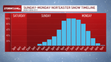
A powerful nor’easter is expected to wallop the tri-state area Sunday into Monday, bringing raging wind gusts, whiteout conditions and up to a foot and a half of snow in New York City while delivering more farther east.
Projected snow totals throughout the region are shocking, given our recent winters, and have continued to rise as the storm approaches. The storm could begin as rainfall midday Sunday before changing over to snow. Conditions quickly deteriorate over the next hours.
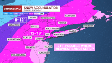
The latest forecasts from Storm Team 4 show that it could be one of the strongest winter storms the New York City area has seen in years. Almost the entire area can expect to see a foot to 18 inches of snow between Sunday afternoon and Monday morning as a result of the late-season nor’easter.
Much of Long Island, as well as Monmouth and Ocean counties in New Jersey, could get as much as two feet of snow.
A blizzard warning is in effect in the city and throughout the region. It has been nearly a decade since the last time a blizzard warning was issued for the five boroughs. Check the latest severe weather alerts for your neighborhood here.
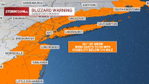
Snowfall rates could hit up to 2 inches an hour at times. Additionally, winds will gust between 30 and 60 mph during the storm, so blowing snow will be a problem, particularly along the coast. A blizzard warning is issued when there is expected to be sustained winds of at least 35 mph and visibility limited to a quarter mile or less due to blowing snow for at least three hours.
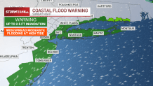
Coastal areas are also at risk of flooding, particularly during Sunday night’s high tide on the Jersey Shore and across southern Suffolk and Nassau counties. A coastal flood warning is in effect Sunday night for all areas near the shore throughout the tri-state.
The storm will wreak havoc on roads and Monday morning commutes along the I-95 corridor from Washington, D.C. to Boston, with NYC squarely in the middle of it. Driving will be treacherous, if not downright dangerous, when the storm is at its full strength.
New York Mayor Zohran Mamdani said the city would expand on efforts it used to deal with a major snowfall weeks ago. But officials held off on deciding whether to open schools Monday for the time being.
“We saw on Friday, there was expectation that the likelihood was that we were going to face maybe 3 to 4 inches of snow. Quickly, that then changed,” Mamdani said. “So we want to make sure that we make a decision based on up-to-date and accurate information.”
NYC brought in additional snow-clearing equipment from outside the city and planned to increase use of geocoding to keep track of bus stops and crosswalks that need clearing, he said.
Many churches canceled Sunday services and other activities. To compensate, St. Veronica Parish in Howell, New Jersey, added an extra Mass on Saturday evening.
“Please stay safe, avoid unnecessary travel, and keep one another in prayer during the storm,” the Rev. Peter James Alindogan posted online.
The storm approaches just as the icy remains of a snowstorm that struck the region weeks earlier were finally melting away. The system will begin pulling away Monday afternoon, so conditions will begin to improve, with dry skies and sunshine taking over Tuesday.
Stay with Storm Team 4 through the weekend as we fine-tune the forecast for you.
The Associated Press contributed to this report.