

NEW YORK (PIX11) — The summer-like heat has entered the tri-state region as temperatures soared into the mid to upper 80s on Tuesday.
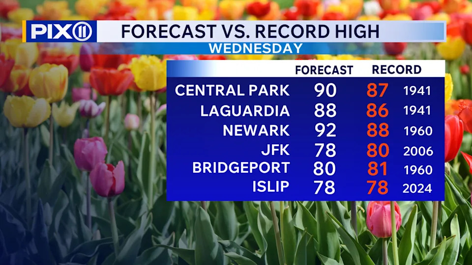
Temperatures on Wednesday may be nearing 90 degrees and shatter records for the day. All that heat also brings the threat of thunderstorms, some of which could be strong to severe.
NYC forecast and PIX11’s Weather Center
A severe thunderstorm watch has been issued for areas well north of the city until 10 p.m. Tuesday. Any storms that form within the watch area could contain gusts of 70 mph, hail, and lots of lightning.
While the city and the rest of the region are not under the watch, an isolated shower or storm cannot be ruled out later in the evening. Overnight temperatures will be in the mid 60s.
(Credit: PIX11)
Wednesday could potentially be the hottest day since last August. Temperatures will soar into the upper 80s, possibly hitting 90 degrees in the city. The current record high in Central Park for the day is 87 degrees, set back in 1941, and we could very well be broken. Similar to Tuesday, a few scattered storms may flare up late in the afternoon.
The rest of the week will continue to feature the summer-like temperatures, with highs in the 80s. The threat of storms may back off on Thursday, but the chances will increase on Friday as a cold front passes through the region.
Discover more local reporting on our homepage
Temperatures will cool down into the 70s over the weekend as an onshore flow develops. Also cold front may bring the chance of scattered showers and storms on Sunday.
By Monday, daytime temperatures will drop further into the 50s under partly cloudy skies.
Andrew Cruz is a digital content producer. A native New Yorker, he joined PIX11 in 2009 as a weather producer. More of his work can be found here.
Copyright 2026 Nexstar Media, Inc. All rights reserved. This material may not be published, broadcast, rewritten, or redistributed.
For the latest news, weather, sports, and streaming video, head to PIX11.