
A multiday outbreak has produced close to 1,000 severe weather reports thus far and will continue into Saturday evening with tornadoes, hail and damaging winds from the Mississippi Valley to the Great Lakes.
Published Apr 16, 2026 12:05 PM CDT
|
Updated Apr 18, 2026 8:28 AM CDT
Even though the peak of the severe weather has passed, Saturday will still be active, and tornadoes still pose a risk for lives and property, with the most intense storms through Saturday evening.
During the severe weather outbreak this week, there have been more than 960 filtered reports of severe weather from Tuesday to Friday night, including at least 60 reports of tornadoes, according to the Storm Prediction Center (SPC). On Friday alone, there have been over 360 filtered reports, with two dozen reports of tornadoes.
The bulk of the severe weather over the past several days has focused on the Midwest and the Plains, with some additional reports of damaging wind and hail in parts of the Northeast. A significant share of the severe weather and tornado reports this week have been from Wisconsin, Iowa, Illinois, Missouri and Kansas.
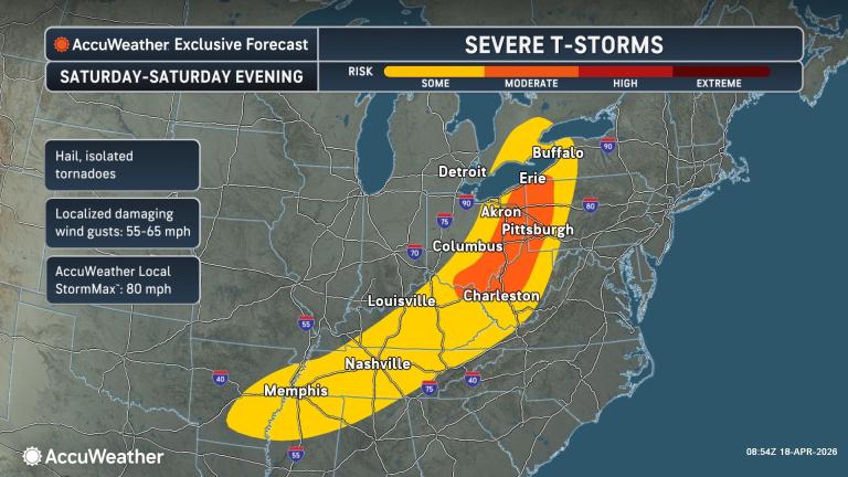
AccuWeather’s severe weather classification is impact-driven and differs from the Storm Prediction Center’s system, with a focus on clarity for the general public.
On Friday and Friday night, severe thunderstorms stretched from the Rio Grande River Valley in Texas to northern and eastern Minnesota and northern Wisconsin. The bulk of reports occurred across northern Missouri, eastern Iowa, northern and central Illinois and far southern Wisconsin. Hail the size of baseballs impacted the region, as well as numerous reports of tornadoes and damaging winds.
GET THE FREE ACCUWEATHER APP
•Have the app? Unlock AccuWeather Alerts™ with Premium+
As of early Saturday morning, over 110,000 customers were without power in the Midwest.
As a cold front tied to the storm system advances, the risk of severe weather will be pushed hundreds of miles farther east this weekend.
Saturday’s severe weather threat zone will extend from middle and eastern Tennessee to southwestern Ontario, including central and eastern Ohio, western Pennsylvania and southwestern New York.
A few tornadoes are possible in the strongest storms Saturday. Dozens of storms may bring damaging wind gusts and hail.
A separate pocket of heaby to locally severe thunderstorms will exist for a time into Saturday over portions of central Texas. The main threats will be from hail, strong wind gusts and urban flooding.
By Sunday, the severe weather potential is likely to have passed its peak, but some gusty thunderstorms may extend from the northern Gulf Coast to the Atlantic Coast.
As the cold front moves through the Southeast, rainfall may be spotty. The heaviest downpours are most likely along the Gulf Coast and from the mid-Atlantic to New England.
Much of the Southeast is in dire need of rain amid a long-term drought and wildfire danger.
Near and north of the severe weather zone, torrential rain has set into motion moderate to major flooding over the Upper Midwest. Additional downpours Friday aggravated existing flooding in the region.
Flash flooding along small streams is feeding into progressively larger rivers across the region. The Muskegon and Grand rivers in Michigan and the Shioc, Menominee and Wolf rivers in Wisconsin will be at major flood stage into this weekend and may take a week or more to fall below flood stage. In some cases, the rivers will crest at record high levels.
Minor flooding is anticipated along a large portion of the Wabash River in Indiana, and minor flooding along a portion of the Mississippi River above St. Louis may last for a couple of weeks or more, even if rainfall stops completely.
Want next-level safety, ad-free? Unlock advanced, hyperlocal severe weather alerts when you subscribe to Premium+ on the AccuWeather app. AccuWeather Alerts™ are prompted by our expert meteorologists who monitor and analyze dangerous weather risks 24/7 to keep you and your family safer.