
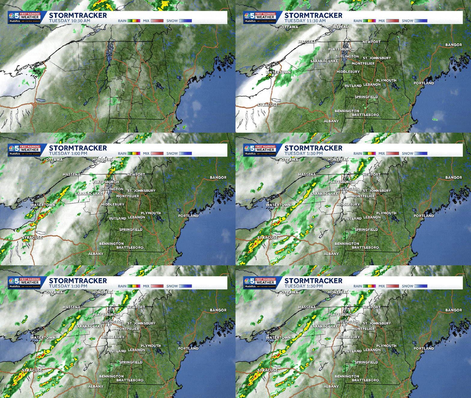
NBC5 meteorologists are tracking a busy period of weather, with showers and locally strong storms Tuesday afternoon and steady rain through most of Wednesday in Vermont and northern New York.Tuesday’s StormsThe main window for storms is expected between 2-7 p.m., as the atmosphere becomes more unstable with daytime heating and a few breaks of sunshine.Ahead of potential storms, temperatures reach the 70s and low 80s across most of Vermont, with slightly cooler highs in New York. A breezy south wind will gust between 30 and 50 mph throughout the day.While not everyone will see a storm, any thunderstorms that develop could produce strong, localized wind gusts up to 60 mph. Frequent lightning and hail are also possible, along with a low chance of a brief, weak spin-up tornado. These storms could knock down tree limbs and lead to isolated power outages in communities where they move through.The storm chance is overall lower across southern Vermont.Wednesday’s RainSteady rain continues in northern areas Tuesday night as a cold front approaches.Periods of moderate to locally heavy rain continue through most of Wednesday. Conditions turn drier Wednesday night into Thursday.A widespread 0.5″ to 1.5″ of soaking rain will add up between Tuesday and Wednesday, limiting the fire danger and accelerating the green-up process.High temperatures Wednesday are split, leaning cooler to the north and warmer south.Extended ForecastA period of cooler-than-average weather continues through late week with highs in the 50s and low 60s. A few showers are possible Saturday, before drier trends for Mother’s Day. STAY WEATHER-AWAREFor the latest weather coverage for your area, click here. Stay updated with alerts in the myNBC5 app, which you can download here.For the best weather information and Vermont and northern New York’s Certified Most Accurate forecast, watch NBC5 News by streaming at this link.Don’t forget to follow NBC5 News on Facebook, X (formerly Twitter), and Instagram.Follow the NBC5 First Warning Weather team on social media:Chief Meteorologist Tyler Jankoski Facebook | X | InstagramMeteorologist Ben Frechette Facebook | X | InstagramMeteorologist Matt DiLoreto Facebook | XMeteorologist Andrew Grautski Facebook | XMeteorologist Marissa Vigevani Facebook | X
SOUTH BURLINGTON, Vt. —
NBC5 meteorologists are tracking a busy period of weather, with showers and locally strong storms Tuesday afternoon and steady rain through most of Wednesday in Vermont and northern New York.
Tuesday’s Storms
The main window for storms is expected between 2-7 p.m., as the atmosphere becomes more unstable with daytime heating and a few breaks of sunshine.
NBC5 News
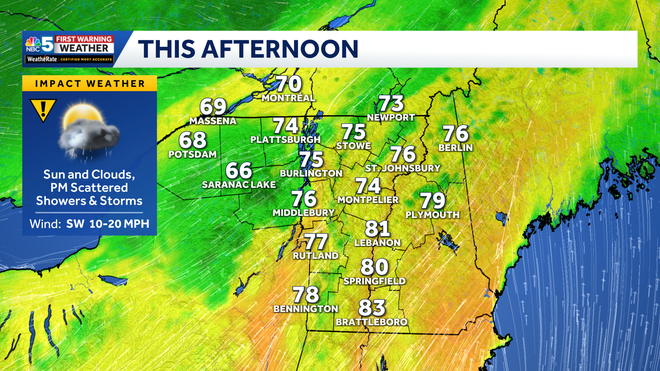
High temperature forecast Tuesday.
Ahead of potential storms, temperatures reach the 70s and low 80s across most of Vermont, with slightly cooler highs in New York. A breezy south wind will gust between 30 and 50 mph throughout the day.
Hearst OwnedNBC5 WPTZ-TV
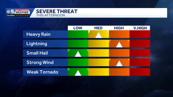
Storm Threat 05-05-2026
While not everyone will see a storm, any thunderstorms that develop could produce strong, localized wind gusts up to 60 mph. Frequent lightning and hail are also possible, along with a low chance of a brief, weak spin-up tornado.
These storms could knock down tree limbs and lead to isolated power outages in communities where they move through.
The storm chance is overall lower across southern Vermont.
Wednesday’s Rain
Steady rain continues in northern areas Tuesday night as a cold front approaches.
NBC5 News
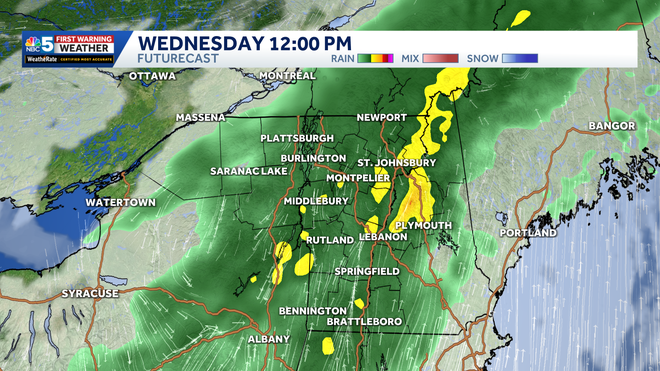
Widespread steady rain likely Wednesday.
Periods of moderate to locally heavy rain continue through most of Wednesday. Conditions turn drier Wednesday night into Thursday.
NBC5 News
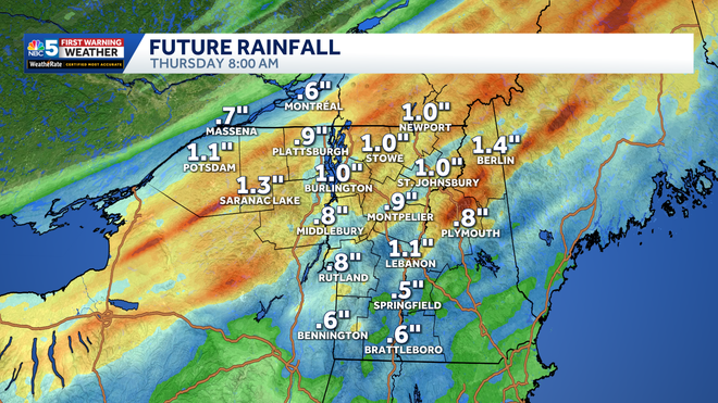
Forecast rainfall amounts through Tuesday and Wednesday combined.
A widespread 0.5″ to 1.5″ of soaking rain will add up between Tuesday and Wednesday, limiting the fire danger and accelerating the green-up process.
NBC5 News
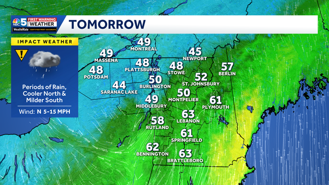
High temperature forecast Wednesday.
High temperatures Wednesday are split, leaning cooler to the north and warmer south.
Extended Forecast
Hearst Owned
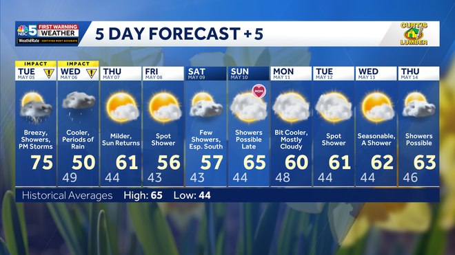
Our latest extended forecast.
A period of cooler-than-average weather continues through late week with highs in the 50s and low 60s. A few showers are possible Saturday, before drier trends for Mother’s Day.
STAY WEATHER-AWARE
For the latest weather coverage for your area, click here. Stay updated with alerts in the myNBC5 app, which you can download here.
For the best weather information and Vermont and northern New York’s Certified Most Accurate forecast, watch NBC5 News by streaming at this link.
Don’t forget to follow NBC5 News on Facebook, X (formerly Twitter), and Instagram.
Follow the NBC5 First Warning Weather team on social media: