
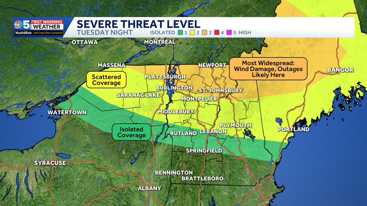
Heat and high humidity, plus instability in the mid-levels of the atmosphere, will provide ample fuel for strong to severe storms to develop Tuesday night. At the same time, strengthening winds higher in the atmosphere, and changing wind direction, will help storms organize and intensify.As always, not every town will be impacted. But those that are could be dealing with significant damage.Damaging straight-line wind gusts in excess of 75 mph are possible, along with large hail and a few tornadoes.One tornado could become strong, meaning EF2 intensity or greater (111+ mph winds). The greatest potential exists from the Northeast Kingdom toward northern Maine.Latest run of FutureCast shows updated timing (low confidence in specific storm placement).Only NBC5 will have direct access to a network of local storm chasers on the ground Tuesday night, bringing you the latest life-saving information as the storms unfold.Watch the video for more.Want more local news? Download our NBC5 mobile app for iOS and Android. STAY WEATHER-AWAREFor the latest weather coverage for your area, click here. Stay updated with alerts in the myNBC5 app, which you can download here.For the best weather information and Vermont and northern New York’s Certified Most Accurate forecast, watch NBC5 News by streaming at this link.Don’t forget to follow NBC5 News on Facebook, X (formerly Twitter), and Instagram.Follow the NBC5 First Warning Weather team on social media:Chief Meteorologist Tyler Jankoski Facebook | X | InstagramMeteorologist Ben Frechette Facebook | X | InstagramMeteorologist Matt DiLoreto Facebook | XMeteorologist Andrew Grautski Facebook | XMeteorologist Marissa Vigevani Facebook | X
SOUTH BURLINGTON, Vt. —
Heat and high humidity, plus instability in the mid-levels of the atmosphere, will provide ample fuel for strong to severe storms to develop Tuesday night.
At the same time, strengthening winds higher in the atmosphere, and changing wind direction, will help storms organize and intensify.
As always, not every town will be impacted. But those that are could be dealing with significant damage.
Damaging straight-line wind gusts in excess of 75 mph are possible, along with large hail and a few tornadoes.
One tornado could become strong, meaning EF2 intensity or greater (111+ mph winds). The greatest potential exists from the Northeast Kingdom toward northern Maine.
Latest run of FutureCast shows updated timing (low confidence in specific storm placement).
Only NBC5 will have direct access to a network of local storm chasers on the ground Tuesday night, bringing you the latest life-saving information as the storms unfold.
Watch the video for more.
Want more local news? Download our NBC5 mobile app for iOS and Android.
STAY WEATHER-AWARE
For the latest weather coverage for your area, click here. Stay updated with alerts in the myNBC5 app, which you can download here.
For the best weather information and Vermont and northern New York’s Certified Most Accurate forecast, watch NBC5 News by streaming at this link.
Don’t forget to follow NBC5 News on Facebook, X (formerly Twitter), and Instagram.
Follow the NBC5 First Warning Weather team on social media: