

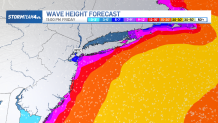
A rare September nor’easter is expected to strengthen as it moves closer to the tri-state area, threatening wind gusts near 60 mph, coastal flooding, and 12-foot waves that could erase entire sections of beach.
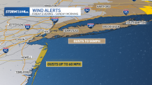
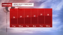
Some of the strong winds began developing Thursday night, alongside choppy waters off Long Island and the Jersey Shore. Expect that to continue, with gusts near 60 mph possibly by the afternoon, even in and around the New York City area. Coastal flood warnings, meanwhile, have been issued for a swath of tri-state shores.
What to expect at the coast
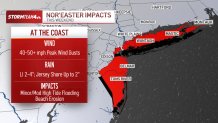
News 4News 4
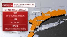
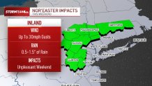
What to expect inland
Wind advisories
Those winds will get even stronger Saturday; gusts up to 60 mph are possible. That’s especially true for the Jersey Shore, where a high wind warning has been issued for coastal Ocean County.
Strom Team 4Strom Team 4
Tracking the flood threat
The breezy conditions come from a high-pressure ridge anchored to the north and an area of low pressure to the south. An easterly wind is funneling between the two, causing a wind-tunnel effect that will strengthen as the low-pressure system deepens by the weekend.
The track of the low is becoming more certain as the European and American long-range forecast models begin to converge on a similar solution.
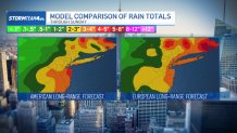
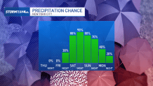
Rain starts Friday evening and will be off and on Saturday and Sunday. Totals won’t be huge for most around the tri-state: In NYC, the Hudson Valley, and much of New Jersey and Connecticut (especially inland), most can expect 1-2 inches of rain over the course of the weekend.
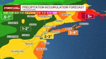
Long Island could see heavier rain, especially eastern Suffolk Count where totals of 3-4 inches are possible. However, the rain won’t come all at once, so flash flooding concerns are muted. If any flash flooding occurs, it will likely be on Long Island.
What we know
Saturday will be the apex of the storm, with the combination of wind high surf having the biggest impact.
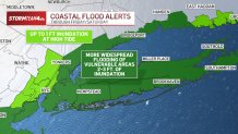
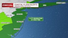
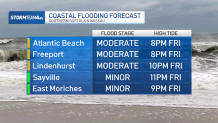
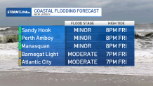
With the seas churning all along the East Coast, it will make coastal erosion and high-tide flooding a concern. Coastal flooding peaks while the wind is from the northeast, pushing ocean water onshore — so the high tides Friday evening, Saturday mid-morning, and Saturday evening will be when coastal flooding is a concern.
Coastal flooding will impact low-lying areas on Long Island and the Jersey Shore in the usual suspect locations. Most coastal communities will see minor coastal flooding, with only a few spots on Long Island and in Ocean County seeing even moderate coastal flooding.
For the vast majority in the tri-state, the storm will bring a wet and windy weekend that puts a big damper on any early fall outdoor plans. It’ll be a weekend to stay inside and read a good book or binge-watch TV, but concerns are minimal beyond that. The region will stay gray and chilly, with afternoon temperatures holding in the 60s.
As far as nor’easters go, this one will be low-to-moderate impact. It is happening early in the fall, so there’s no snow involved.
Nor’easters are typically associated with strong coastal lows during the winter months that deliver howling winds, blowing snow, and whiteout conditions that grind the coast to a halt. This weekend’s storm is not that.
We also don’t expect it to be an extremely intense low-pressure system at its height Saturday into Sunday. Winds will be dampened somewhat because of that.
The wind will relax somewhat Sunday, and the rain will taper off late Sunday into Monday. The low begins to weaken and eventuall exitst the region entirely, leaving quite nice weather for us next week. Expect highs in the 70s with plenty of sunshine.