
NEW YORK – The nor’easter impacting the tri-state area is bringing strong winds, heavy rain and the risk of significant coastal flooding to parts of Long Island and New York City through Monday morning.
State of Emergency and rail service
New York Gov. Kathy Hochul declared a State of Emergency for eight southern New York counties on Sunday as a Nor’easter began to make its way to New York.
The State of Emergency applies to the Bronx, Kings, Nassau, New York, Queens, Richmond, Suffolk and Westchester counties. It also extends to counties contiguous with these, according to a press release from the governor’s office.
As a result of the State of Emergency, New York City’s annual Columbus Day Parade has been canceled.
“Due to the Governor’s declaration of a State of Emergency this evening in response to the dangerous weather conditions brought on by the Nor’easter, including high winds, heavy rain and flooding in surrounding areas, we must cancel the 81st Annual Columbus Day Parade for the safety of all participants and viewers,” parade organizers said in a statement provided to FOX 5 NY.
“While we cannot reschedule this year’s parade, we look forward to seeing everyone at our 82nd annual parade in 2026,” they added.
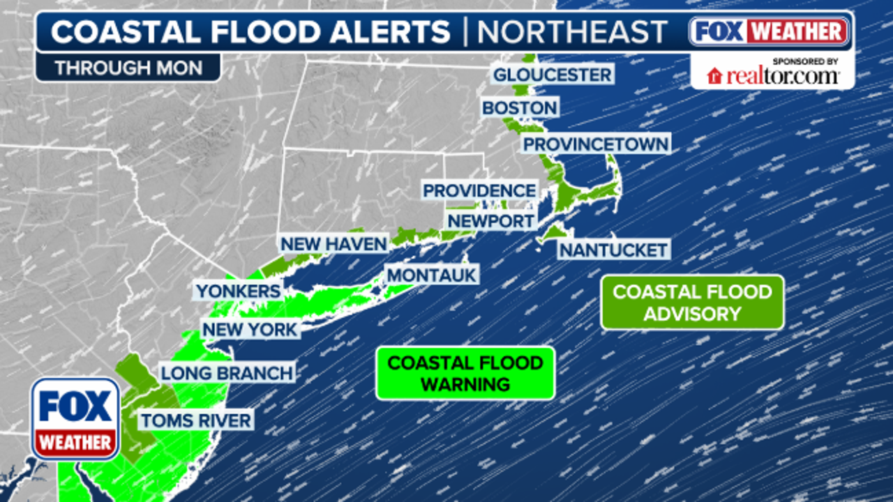
In addition to the State of Emergency, a coastal flood warning and a wind advisory have been issued for Long Island, New York City and Southern Westchester counties through 8 p.m. on Monday. A high wind warning is currently in effect for Eastern Suffolk County, as well.
New Jersey Transit also announced Sunday that service on the North Jersey Coast Line (NJCL) and the Atlantic City Rail Line (ACRL) will be impacted due to the heavy rain, strong winds and potential flooding that’s expected through Monday evening.
Specifically, NJCL service is suspended between Bay Head and Long Branch through the end of service on Oct. 13. ACRL service is suspended between Atlantic City and Philadelphia 30th Street Station through the same timeframe.
Nor’easter forecast
What we know:
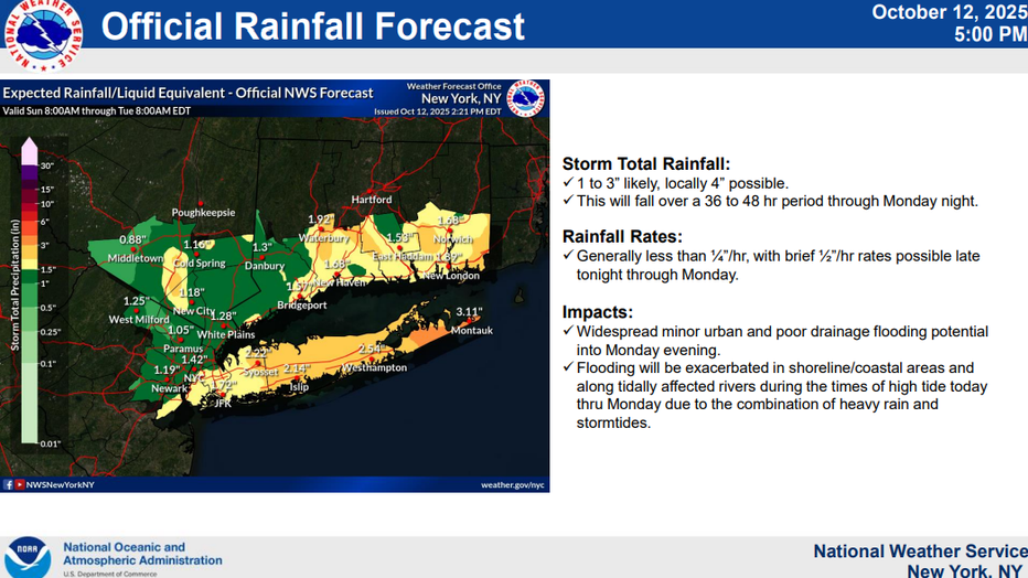
The National Weather Service says the nor’easter will bring moderate to major coastal flooding across the south shore bays of Nassau and southwestern Suffolk counties during high tide cycles Sunday and early Monday. Other parts of the coast face a minor to moderate flooding threat, with widespread dune erosion and localized overwash possible along the Atlantic beaches.
National Oceanic and Atmospheric Administration
Damaging winds are expected to increase through Sunday evening, especially over eastern Long Island, where gusts could reach 50–60 mph. Strong winds will continue across much of the coast through early Monday, potentially leading to downed trees and isolated power outages.
Rain will continue throughout the day, with an average of 1.5 to 3 inches expected — the heaviest totals near the coast. The NWS warns that areas with poor drainage could experience localized flooding.
National Oceanic and Atmospheric Administration
Storm and gale warnings remain in effect for coastal waters, where rough surf and dangerous rip currents are making for hazardous marine conditions.
Jersey Shore warnings
Across counties down the shore, officials have issued a coastal flood warning and declared a state of emergency as the nor’easter slams the coastline.
Residents from beachfront communities to inland neighborhoods should brace for rising tides, storm surge and flooding in low-lying areas.
Local governments are moving emergency resources and mobilizing crews to monitor vulnerable zones, especially near bays, inlets and tidal waterways.
During high tide cycles, particularly later Sunday into Monday, water levels may surge inland, overtopping roads and flooding basements. Expect minor to moderate flooding in many coastal zones, with major flooding possible in especially exposed bayside and barrier island neighborhoods.
Emergency officials urge people to avoid driving through flooded streets, stay off the beach and move vehicles to higher ground well ahead of the worst tides.
The Source: This article gathered information from FOX Weather, local county governments, the National Weather Service, Gov. Kathy Hochul’s office and NJ Transit.