
The NBC5 First Warning Weather Team is monitoring a complex system with rain, ice, mountain snow, and wind all set to impact Vermont and Northern New York over the weekend. Leading up to the event, Friday’s forecast is tame with clouds and scattered flurries. Saturday will feature increasing clouds, but most of the daylight hours are dry.Saturday Night (Icy Mix)The first round of precipitation will arrive after sunset into the first half of Saturday night. While temperatures will warm above freezing in the valleys, cold air will be tougher to dislodge in the mountains, leading to a risk for freezing rain. Expect a glaze to 0.1″ of ice to develop in pockets across the Adirondacks and along/east of the Green Mountains. The window for icing will end around sunrise Sunday, but early travelers may encounter slick untreated roads, sidewalks, driveways, decks, etc. in these areas.Sunday (Upslope Snow, Wind, Cold)Sunday is an alert weather day with widespread, persistent mountain snow through the day, coupled with a gusty northwest wind and sharply colder temperatures.High temperatures will peak around 40 degrees early in the day — shortly after sunrise, strong northwesterly winds begin bringing temperatures close to, and eventually below, freezing by afternoon.With the combination of fresh snow and a potential layer of ice underneath, roads may turn treacherous without proper treatment, especially after sunset. Use caution if traveling outside of the Champlain Valley during the day.Gusts will approach 25 to 35 mph through Sunday afternoon, strongest in the mountains. Winds will last through most of Monday. Upslope snow will quickly develop Sunday morning and last through early Monday morning. Widespread totals of 2-4″ are expected in many mountain communities across northern New York and northern Vermont. Northern summits like Jay Peak and Mt. Mansfield surpass 8″ through Monday. Less snow accumulation expected south.Next WeekCold conditions persist Monday with lingering upslope snow showers and temperatures only reaching the low/mid 30s.The overall pattern continues with many clouds, colder than normal days, and more opportunities for snow showers leading up to the following weekend.STAY WEATHER-AWAREFor the latest weather coverage for your area, click here. Stay updated with alerts in the myNBC5 app, which you can download here.For the best weather information and Vermont and northern New York’s Certified Most Accurate forecast, watch NBC5 News by streaming at this link.Don’t forget to follow NBC5 News on Facebook, X (formerly Twitter), and Instagram.Follow the NBC5 First Warning Weather team on social media:Chief Meteorologist Tyler Jankoski Facebook | X | InstagramMeteorologist Ben Frechette Facebook | X | InstagramMeteorologist Matt DiLoreto Facebook | XMeteorologist Andrew Grautski Facebook | XMeteorologist Marissa Vigevani Facebook | X
SOUTH BURLINGTON, Vt. —
The NBC5 First Warning Weather Team is monitoring a complex system with rain, ice, mountain snow, and wind all set to impact Vermont and Northern New York over the weekend.
Leading up to the event, Friday’s forecast is tame with clouds and scattered flurries. Saturday will feature increasing clouds, but most of the daylight hours are dry.
Saturday Night (Icy Mix)
")
NBC5 News
Icy mix arrives Saturday night.
The first round of precipitation will arrive after sunset into the first half of Saturday night. While temperatures will warm above freezing in the valleys, cold air will be tougher to dislodge in the mountains, leading to a risk for freezing rain.
")
NBC5 News
Areas where a glaze of ice may develop by early Sunday morning.
Expect a glaze to 0.1″ of ice to develop in pockets across the Adirondacks and along/east of the Green Mountains. The window for icing will end around sunrise Sunday, but early travelers may encounter slick untreated roads, sidewalks, driveways, decks, etc. in these areas.
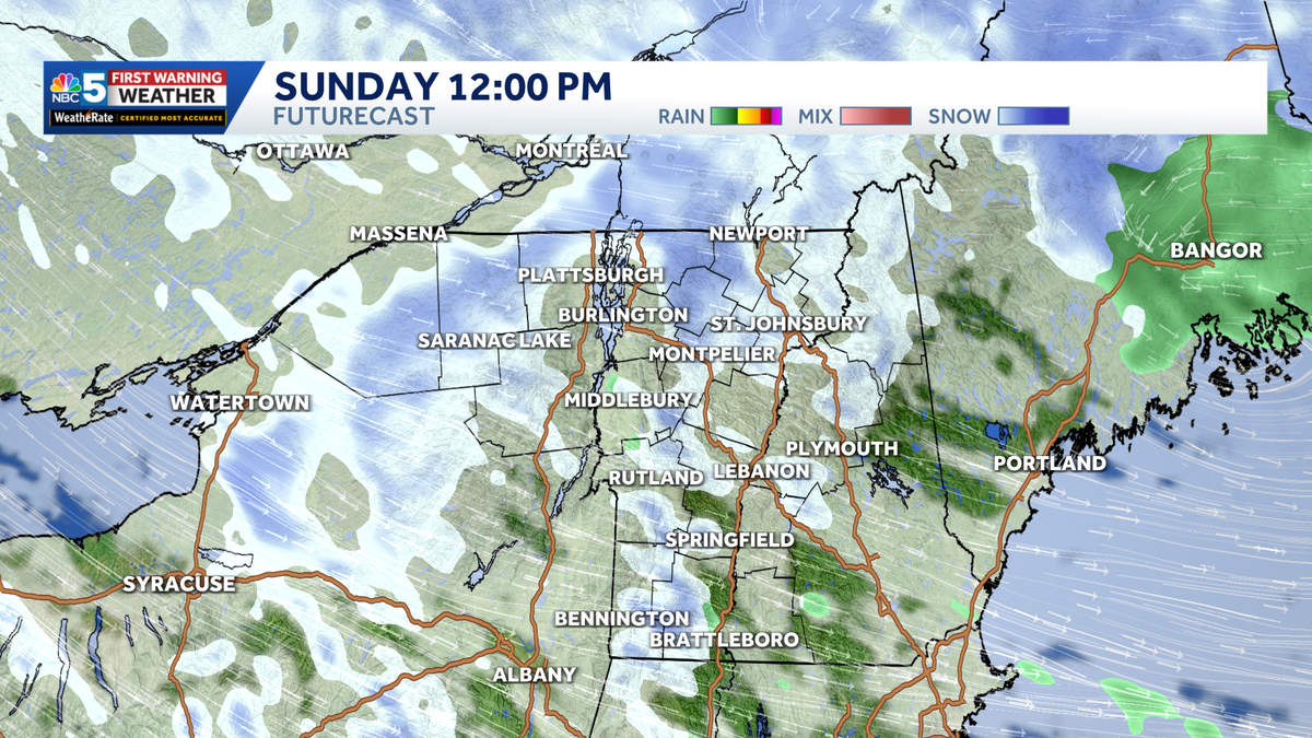
Sunday (Upslope Snow, Wind, Cold)
")
NBC5 News
Widespread mountain snow showers develop Sunday afternoon into the evening.
Sunday is an alert weather day with widespread, persistent mountain snow through the day, coupled with a gusty northwest wind and sharply colder temperatures.
High temperatures will peak around 40 degrees early in the day — shortly after sunrise, strong northwesterly winds begin bringing temperatures close to, and eventually below, freezing by afternoon.
")
NBC5 News
Temperatures drop below freezing through Sunday, especially in the mid-afternoon.
With the combination of fresh snow and a potential layer of ice underneath, roads may turn treacherous without proper treatment, especially after sunset. Use caution if traveling outside of the Champlain Valley during the day.
")
NBC5 News
Strong northwesterly winds may gust over 30 mph through Monday morning.
Gusts will approach 25 to 35 mph through Sunday afternoon, strongest in the mountains. Winds will last through most of Monday.
")
NBC5 News
Forecast snowfall amounts through Monday.
Upslope snow will quickly develop Sunday morning and last through early Monday morning. Widespread totals of 2-4″ are expected in many mountain communities across northern New York and northern Vermont. Northern summits like Jay Peak and Mt. Mansfield surpass 8″ through Monday. Less snow accumulation expected south.
Next Week
Cold conditions persist Monday with lingering upslope snow showers and temperatures only reaching the low/mid 30s.
The overall pattern continues with many clouds, colder than normal days, and more opportunities for snow showers leading up to the following weekend.
STAY WEATHER-AWARE
For the latest weather coverage for your area, click here. Stay updated with alerts in the myNBC5 app, which you can download here.
For the best weather information and Vermont and northern New York’s Certified Most Accurate forecast, watch NBC5 News by streaming at this link.
Don’t forget to follow NBC5 News on Facebook, X (formerly Twitter), and Instagram.
Follow the NBC5 First Warning Weather team on social media: