
 article
NEW YORK – Snow could be coming to the tri-state just as December begins, and the National Weather Service now says some areas north and west of New York City could see higher totals than earlier expected.
The latest NWS briefing, issued early Monday, shows a stronger signal for accumulating snow inland as a coastal storm moves in Tuesday.
What we know about potential snow
NYC and the immediate coast may see little to no snow, but parts of the Hudson Valley, northern New Jersey and Connecticut are in line for several inches before the changeover to rain.
The National Weather Service says snow will begin early Tuesday across the interior, with a transition to rain from south to north during the morning. According to NWS, snowfall projections have increased for some counties:
Highest predicted totals Orange County: 4 to 7 inches possibleWestern Passaic (N.J.), Putnam (N.Y.): 3 to 5 inches Moderate totals Rest of the Lower Hudson Valley, much of N.J.: 1 to 3 inches before mixing and changing to rain Tuesday morning Lowest totals New York City: little or no snowLong Island: no snow currently expected
A map from the latest NWS briefing highlighted a corridor from northern New Jersey through the Hudson Valley and into interior Connecticut with the greatest potential for several inches of snow before the changeover.
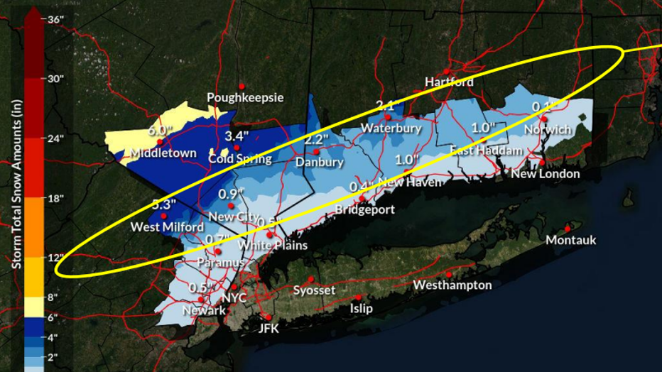
Most Likely Snowfall – Official Forecast from NWS.
By Tuesday afternoon, most lower-elevation areas will see plain rain before precipitation tapers off as a light rain/snow mix.
The city activated parts of its flash-flood response plan Sunday in advance of the incoming storm, preparing for drainage issues, wet roads and reduced visibility as rain becomes the dominant precipitation type.
Advisories and alerts A Winter Storm Watch is in effect for Orange County from 4 a.m. to 10 p.m. Tuesday.Winter Weather Advisories are in effect for Putnam, Rockland, and western Passaic counties during the same timeframe.Interior areas could see hazardous travel Tuesday morning due to snow-covered roads. What time could it snow?
The NWS predicted the most likely shift from snow to a wintry mix and then rain:
4 a.m.: Widespread snow inland; mix/rain near the coast7 a.m.: Snow continues inland; NYC transitions toward a mix10 a.m.: Rain moves into the city; mixing continues northward1–4 p.m.: Most of the region is rain, except pockets of lingering snow northwest7 p.m.: Precipitation tapers, ending as a light mix inland
What we don’t know:
Forecasters still note uncertainty in the exact track of the low-pressure system.
A shift south and east could keep colder air in place longer — bringing higher totals farther south into coastal CT and possibly closer to NYC. A warmer track would sharply reduce totals along I-95.
What’s next:
The National Weather Service will issue another briefing by 5 p.m. Monday, and officials urge commuters to prepare for slippery early-morning conditions north and west of the city.
The Source: This article is based on the latest forecast briefing from the National Weather Service.