

NEW YORK (PIX11) – A winter storm is heading toward New York and New Jersey on Tuesday morning, bringing snow and cold temperatures.
Gov. Phil Murphy declared a state of emergency in New Jersey on Monday, as northwestern counties could see heavy snow, sleet and freezing rain. New York City is expected to see heavy rain from this storm, according to PIX11 News meteorologists.
NYC forecast and PIX11’s Weather Center
The winter storm has caused schools to close or delay their openings. To find a list, click here.
Here’s everything you need to know about the winter storm:
Timeline
A winter weather advisory is in effect for Rockland, Putnam and Orange counties in New York and Passaic County in New Jersey through 10 p.m. on Tuesday.
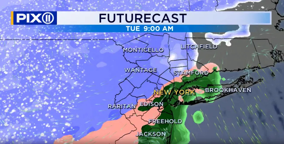
A winter storm is heading to New York and New Jersey on Tuesday morning, bringing with it snow and cold temperatures. (Credit: Mike Masco, PIX11 News)
Snow will start falling in the northern and western parts of New York just after 7 a.m. A snow/sleet mix is expected near New York City and the Jersey Shore.
That mix will change over to cold rain. Temperatures will be close to the freezing mark for higher elevations and temperatures in the low-40s for coastal spots.
Snow totals
In areas expected to see snow, accumulation between 1 to 3 inches is possible. Some parts could see anywhere from 2 to 4 inches of snow, according to the National Weather Service.
Future forecast
Wednesday will be mostly sunny and chilly as high pressure moves in from the west. The high will be 40 in the city and upper-30s to low-40s in the suburbs.
Thursday will feature a mix of sun and clouds as a front moves through the region during the afternoon. The high will be 39 in the city and mid to upper-30s in the suburbs.
Friday will be partly cloudy with a chance of snow showers late in the day as a storm system passes to the south of the area. Temperatures will be well below average as arctic air will overspread the region. Afternoon highs will struggle to reach the freezing mark over much of the region.
Saturday will be partly cloudy with a high of 41 in the city and low to mid-40s in the suburbs.
Sunday will be partly cloudy and chilly with a high of 39 in the city and upper-30s to low-40s for the suburbs.
Monday will be mostly sunny, windy, and cold as another round of arctic air will settle in over the region. The high will be 32 in the city and low to mid-30s in the suburbs.
Erin Pflaumer is a digital content producer from Long Island who has covered both local and national news since 2018. She joined PIX11 in 2023. See more of her work here.
Copyright 2025 Nexstar Media, Inc. All rights reserved. This material may not be published, broadcast, rewritten, or redistributed.
For the latest news, weather, sports, and streaming video, head to PIX11.