
NEW YORK – A messy winter storm is sweeping across New York and New Jersey Tuesday, bringing a mix of heavy rain, wet snow and pockets of ice that will snarl travel through both the morning and evening commutes.
SKIP TO: Snow timeline | Snow totals | Weather forecast today
Here’s when and how much it could snow today.
Is it going to snow today?
What we know:
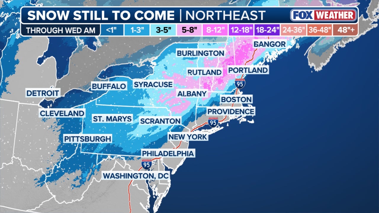
According to the National Weather Service, the system, which has also prompted dozens of school closings across the region, is expected to bring up to 5 inches of snow to the area.
Dig deeper:
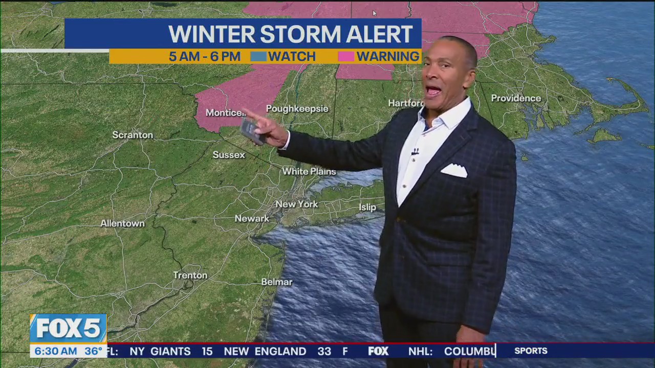
Multiple Winter Weather Advisories were issued across the tri-state area.
NJ State of emergency
New Jersey Gov. Phil Murphy declared a state of emergency at 5 a.m. ET Tuesday, citing “significant impacts” expected from snow, rain and icing in the northern half of the state. The declaration allows state agencies to coordinate resources and support local emergency response efforts.
Dig deeper:
In Putnam, Rockland and Western Passaic counties, a Winter Weather Advisory remains in effect until 10 p.m., with 1 to 3 inches of wet snow expected.
Slick conditions are likely on roads, bridges and overpasses.

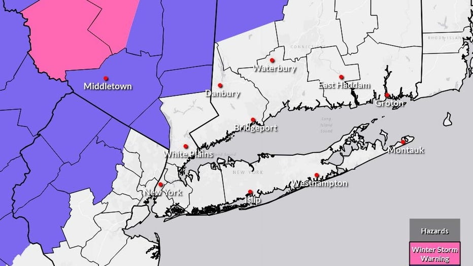
Expected snowfall. (FOX Weather)
Sussex County, New Jersey, remains under an advisory through 7 p.m., with 1 to 3 inches of snow, locally up to 4 inches in higher elevations, and a light glaze of ice possible.
Warren County, New Jersey, along with Berks, Lehigh and Northampton counties in Pennsylvania, remains under an advisory until 1 p.m., with 1 to 3 inches of snow, up to 4 inches in elevated terrain, and minor icing anticipated.
FOX 5 NY meteorologist Mike Woods warned early Tuesday that the storm would “get real sloppy for us all,” noting that clouds and showers were already merging and would intensify through the morning.
Timeline:
6:45 a.m.: Temperatures in areas like Newark sit just above freezing. Rising dew points allow precipitation to reach the ground.
Around 8 a.m.: The main precipitation shield moves in, bringing widespread heavy rain to New York City and nearby lower-elevation areas. Woods said some wet snowflakes may fall at the onset, but the storm will quickly turn to steady rain.
5 a.m.–10 a.m. (overlapping period): Snow falls inland while rain spreads into New York City and coastal areas, making roads slippery.
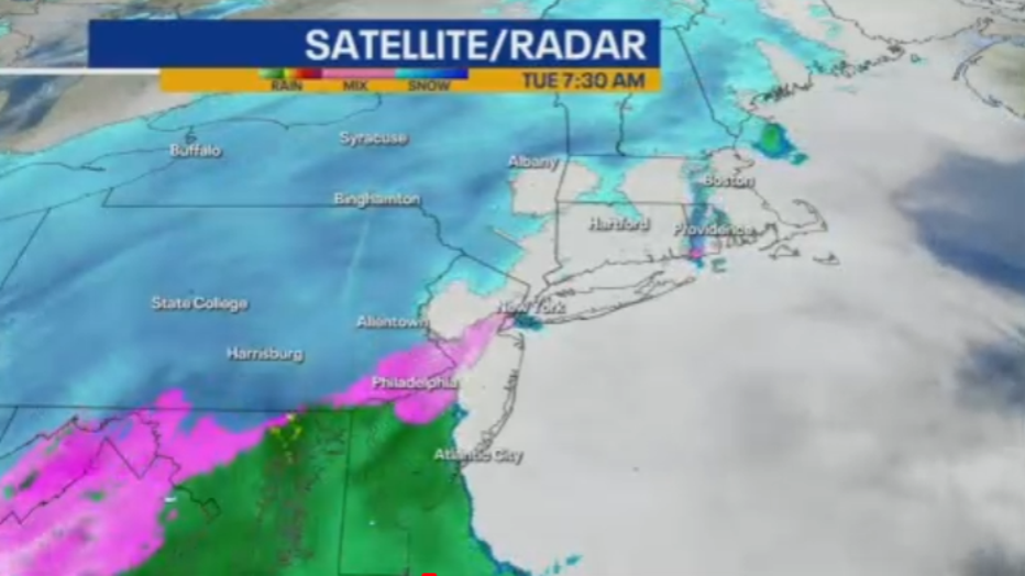
Late morning through afternoon (10 a.m.–4 p.m.): Rainfall rates increase, raising the risk of localized flooding in the city and suburbs. Snow continues north and west of the city.
5 to 6 p.m. (4 p.m.–10 p.m. window): The storm begins to move out from west to east, though snow lingers in far northwestern counties where temperatures remain colder. Travel remains slow.
After 10 p.m.: Clearing skies and falling temperatures may cause refreezing on untreated roads and walkways.
Tuesday night: Chance of early rain, then clearing. Low around 30 degrees with wind chills in the 20s.
Wednesday: Sunny, high near 41, with wind chills in the mid-20s to mid-30s.
Wednesday night: Partly cloudy, low near 31.
Wednesday: Sunny, high near 41, with wind chills in the mid-20s to mid-30s and a chance of rain.
Wednesday night: Partly cloudy, low near 31.
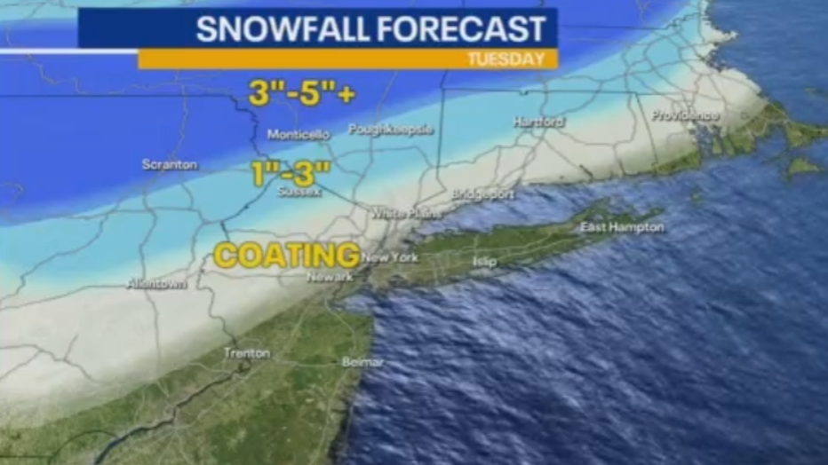
Expected snowfall. (FOX Weather)
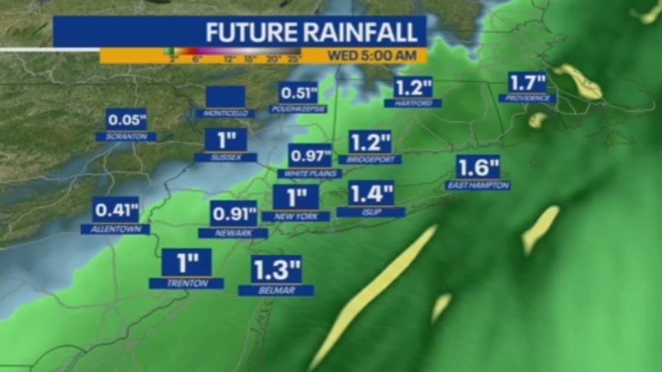
Snowfall projections vary widely across the region. Upstate New York is expected to see 5 to 8 inches, with interior parts of the Northeast potentially reaching 5 to 10 inches. Higher elevations in New York and New Jersey could see 3 to 5 inches, while New York City, Long Island and coastal New Jersey will see mostly rain.
FOX Weather updates NYC weather radar
Click here for more information.
The Source: This report is based on information from the National Weather Service, Fox Weather and FOX 5 NY’s meteorologist Mike Woods.