
The NBC5 First Warning Weather Team is tracking widespread snow and slick travel conditions across Vermont and Northern New York on Wednesday, Dec. 10 that could make for a slippery commute.After bitterly cold air on Monday night and light snow on Tuesday evening, most parts of our region will see widespread snow beginning Wednesday morning.Snow will be heavy in the Champlain Valley for a few hours early Wednesday before ending. Meanwhile, the rest of Vermont and Northern New York will continue to see heavy snow and possibly some rain throughout the day.Because temperatures will be near freezing, the mix of snow and rain will make for slick and slippery travel conditions, so drivers should use caution on the roads.Estimated Snow TotalsAs of Monday, the Champlain Valley is only expected to get between a dusting and two inches of fresh snow from Wednesday’s storm. However, a widespread two to four inches of snow is likely elsewhere in Vermont and Northern New York.Certain areas could see more than four inches of snow, with the bullseye of this storm bringing a potential eight inches of snow to Stratton Mountain.However, it is important to note that this storm is highly location-based, meaning some areas could see several inches of snow, while nearby towns could see very little snow.What is certain is that travel will be treacherous for most on Wednesday, so be sure to take extra time and be cautious when driving to and from your destination.Looking ahead to the rest of the week, bitter cold temperatures continue into next week, with lows in the teens and single digits.NBC5 will continue to track conditions and provide updates as we look toward Wednesday. STAY WEATHER-AWAREFor the latest weather coverage for your area, click here. Stay updated with alerts in the myNBC5 app, which you can download here.For the best weather information and Vermont and northern New York’s Certified Most Accurate forecast, watch NBC5 News by streaming at this link.Don’t forget to follow NBC5 News on Facebook, X (formerly Twitter), and Instagram.Follow the NBC5 First Warning Weather team on social media:Chief Meteorologist Tyler Jankoski Facebook | X | InstagramMeteorologist Ben Frechette Facebook | X | InstagramMeteorologist Matt DiLoreto Facebook | XMeteorologist Andrew Grautski Facebook | XMeteorologist Marissa Vigevani Facebook | X
SOUTH BURLINGTON, Vt. —
The NBC5 First Warning Weather Team is tracking widespread snow and slick travel conditions across Vermont and Northern New York on Wednesday, Dec. 10 that could make for a slippery commute.
After bitterly cold air on Monday night and light snow on Tuesday evening, most parts of our region will see widespread snow beginning Wednesday morning.
Snow will be heavy in the Champlain Valley for a few hours early Wednesday before ending. Meanwhile, the rest of Vermont and Northern New York will continue to see heavy snow and possibly some rain throughout the day.
This content is imported from Facebook.
You may be able to find the same content in another format, or you may be able to find more information, at their web site.
Because temperatures will be near freezing, the mix of snow and rain will make for slick and slippery travel conditions, so drivers should use caution on the roads.
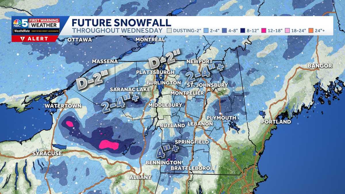
Estimated Snow Totals
As of Monday, the Champlain Valley is only expected to get between a dusting and two inches of fresh snow from Wednesday’s storm. However, a widespread two to four inches of snow is likely elsewhere in Vermont and Northern New York.
Certain areas could see more than four inches of snow, with the bullseye of this storm bringing a potential eight inches of snow to Stratton Mountain.
However, it is important to note that this storm is highly location-based, meaning some areas could see several inches of snow, while nearby towns could see very little snow.
This content is imported from Facebook.
You may be able to find the same content in another format, or you may be able to find more information, at their web site.
What is certain is that travel will be treacherous for most on Wednesday, so be sure to take extra time and be cautious when driving to and from your destination.
Looking ahead to the rest of the week, bitter cold temperatures continue into next week, with lows in the teens and single digits.
NBC5 will continue to track conditions and provide updates as we look toward Wednesday.
STAY WEATHER-AWARE
For the latest weather coverage for your area, click here. Stay updated with alerts in the myNBC5 app, which you can download here.
For the best weather information and Vermont and northern New York’s Certified Most Accurate forecast, watch NBC5 News by streaming at this link.
Don’t forget to follow NBC5 News on Facebook, X (formerly Twitter), and Instagram.
Follow the NBC5 First Warning Weather team on social media: