Widespread snow, slick travel Wednesday in Vermont and Northern New York
Heaviest snow expected late morning and early afternoon
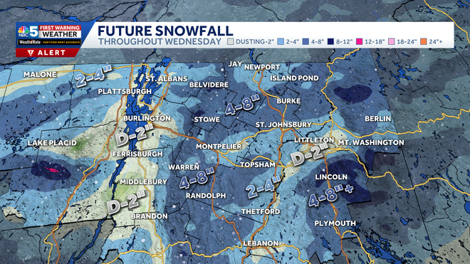
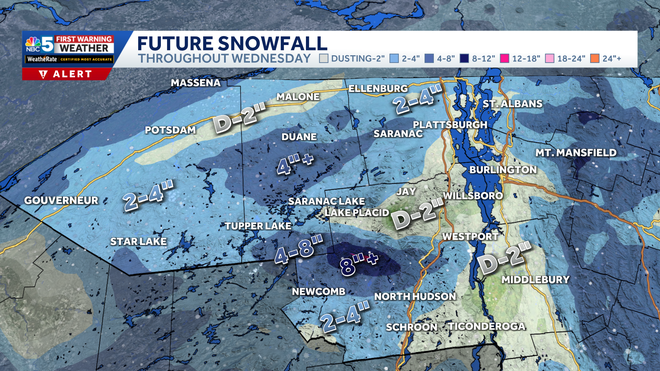
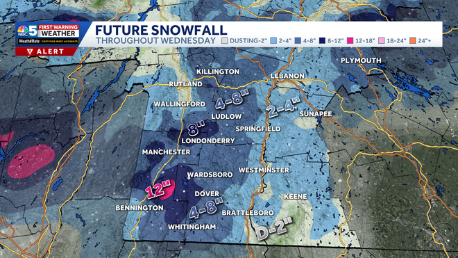
Now NBC 5’s certified most accurate forecast. Your time now is 6:47 and you’re taking *** live look at buried. Temperature there is 23 degrees. The morning commute is already underway. Wet roads though. Yeah, we’re just starting to see the first few flakes coming in south and west as expected, it’s still going to take *** couple more hours for it to really pick up, but late morning, early afternoon, roads are going to quickly. Go downhill like that. Probably the best that they’re going to look this morning then, Andrew, I would say so. Uh, we’ve got some cold pavement too. The air is 23. I’m sure the road surface is similar. We’ve had *** lot of cold air the last few days, so as the snow comes in, it’s going to have no problem sticking. So, uh, snow covered roads turning slippery before long. Storm tracker for now still pretty quiet, mostly cloudy. You see the snow there in central New York, just some light. Light snow showers right now from Manchester up to the Rutland area into Addison County. Nothing of much significance. We’ll show you, uh, downtown Rutland looking at Merchant’s Row. Traffic flowing just fine, looking, uh, like some mostly bare pavement there. The weather lab with Charlotte on Route 22, Essex County, New York, near Crown Point. We’ll get *** report from her soon. Looks like just *** little bit of light snow in that area. Saranac Lake looking at Broadway. In good shape still for the time being. So mostly 20s on the temperature map, mid and upper 20s at that, do have some teens in the Northeast Kingdom, not nearly as cold as yesterday morning. Still want the layers though. All right, here’s Futurecast. By late morning, 1011 a.m., boom, the snow really fills in and it picks up in intensity. The heaviest snow rates probably early this afternoon, could be around an inch an hour for *** short time. And then by this evening, the snow, the snow starts to break up, become *** little more spotty. Do you still think the side roads, the higher elevations, will be slippery? Perhaps the main interstate and the main roads trending towards being wet and slushy by this point. Temperatures will be right near the freezing mark, especially as the snow winds down *** little bit. The road crews will have time to plow and put down treatment, so it may be *** little better on the roads later today. Overnight tonight, snow showers still around. Tomorrow’s *** quieter weather day, clouds and some sunshine in the valleys, but if you head towards the northern green mountains, the Adirondacks, snowing *** lot of the day, *** few more inches adding up in the high elevations, even through tomorrow night, and then by Friday, quieter for all of us, *** mix of sun and clouds, just *** few mountain flurries. So this is the snow map through tonight, generally *** few inches in the higher elevations. 2 to 4 for *** lot of the Adirondacks, areas of 4 inches plus south of Duane there in Franklin County into the high peaks, probably an inch or 2 for the Tri- Lakes and the Malone area, dusting to *** couple inches in the Champlain Valley. Definitely not *** big storm, but you head towards the Route 100 stretch, 4 to 8 inches near the Green Mountains into the Northeast Kingdom, and then southern Vermont, 4 to 8 inches near the southern. Mountain spine and places like Stratton and Magic Mountain, Okemo could be around 8 inches, 2 to 4 for places like Springfield and Westminster, probably just an inch or 2 in Brattleborough. So for tomorrow, the mountain snow lingers, it’s breezy out of the west. *** drier day on Friday, mostly cloudy, 30 on Saturday, Pretty nice. Snow showers back to the low 20s by Sunday.
NBC5 First Warning Meteorologist
The NBC5 First Warning Weather Team is tracking widespread snow and slick travel conditions across Vermont and Northern New York on Wednesday, Dec. 10 that could make for a slippery evening commute. The steadiest snow arrives mid-morning Wednesday, around 9 to 10 AM.Snow will come down heavily in the Champlain Valley late morning and early afternoon Wednesday before tapering off, thanks to a downsloping wind that will make the snow more spotty by the evening commute. Meanwhile, the higher elevations of Vermont and northern New York will hold onto steadier snow most of the day.Because temperatures will be near freezing, the mix of snow and rain will make for slick and slippery travel conditions, so drivers should use caution on the roads.Estimated Snow TotalsThe Champlain Valley is only expected to get between a dusting and two inches of fresh snow from Wednesday’s storm. However, many higher elevation towns in Vermont and northern New York can expect over four inches.Certain areas could pick up around 8 inches, especially in the High Peaks of the Adirondacks and the southern Green Mountain Spine, including Stratton.However, it is important to note that this storm is highly location-based, meaning some areas could see several inches of snow, while nearby towns could see very little snow.What is certain is that travel will be treacherous for most on Wednesday, so be sure to take extra time and be cautious when driving to and from your destination.Looking ahead to the rest of the week, cold than average temperatures continue, with highs in the 20s, and lows in the single digits and teens.NBC5 will continue to track conditions and provide updates as we look toward Wednesday. Snow breakdown by regionNorthern Vermont/Champlain Valley/New HampshireNorthern New York/Champlain ValleySouthern VermontSTAY WEATHER-AWAREFor the latest weather coverage for your area, click here. Stay updated with alerts in the myNBC5 app, which you can download here.For the best weather information and Vermont and northern New York’s Certified Most Accurate forecast, watch NBC5 News by streaming at this link.Don’t forget to follow NBC5 News on Facebook, X (formerly Twitter), and Instagram.Follow the NBC5 First Warning Weather team on social media:Chief Meteorologist Tyler Jankoski Facebook | X | InstagramMeteorologist Ben Frechette Facebook | X | InstagramMeteorologist Matt DiLoreto Facebook | XMeteorologist Andrew Grautski Facebook | XMeteorologist Marissa Vigevani Facebook | X
The NBC5 First Warning Weather Team is tracking widespread snow and slick travel conditions across Vermont and Northern New York on Wednesday, Dec. 10 that could make for a slippery evening commute.
The steadiest snow arrives mid-morning Wednesday, around 9 to 10 AM.
Snow will come down heavily in the Champlain Valley late morning and early afternoon Wednesday before tapering off, thanks to a downsloping wind that will make the snow more spotty by the evening commute.
Meanwhile, the higher elevations of Vermont and northern New York will hold onto steadier snow most of the day.
This content is imported from Facebook.
You may be able to find the same content in another format, or you may be able to find more information, at their web site.
Because temperatures will be near freezing, the mix of snow and rain will make for slick and slippery travel conditions, so drivers should use caution on the roads.
Estimated Snow Totals
The Champlain Valley is only expected to get between a dusting and two inches of fresh snow from Wednesday’s storm. However, many higher elevation towns in Vermont and northern New York can expect over four inches.
Certain areas could pick up around 8 inches, especially in the High Peaks of the Adirondacks and the southern Green Mountain Spine, including Stratton.
However, it is important to note that this storm is highly location-based, meaning some areas could see several inches of snow, while nearby towns could see very little snow.
This content is imported from Facebook.
You may be able to find the same content in another format, or you may be able to find more information, at their web site.
What is certain is that travel will be treacherous for most on Wednesday, so be sure to take extra time and be cautious when driving to and from your destination.
Looking ahead to the rest of the week, cold than average temperatures continue, with highs in the 20s, and lows in the single digits and teens.
NBC5 will continue to track conditions and provide updates as we look toward Wednesday.
Snow breakdown by region
Northern Vermont/Champlain Valley/New Hampshire

Northern New York/Champlain Valley

Southern Vermont

STAY WEATHER-AWARE
For the latest weather coverage for your area, click here. Stay updated with alerts in the myNBC5 app, which you can download here.
For the best weather information and Vermont and northern New York’s Certified Most Accurate forecast, watch NBC5 News by streaming at this link.
Don’t forget to follow NBC5 News on Facebook, X (formerly Twitter), and Instagram.
Follow the NBC5 First Warning Weather team on social media:

