
STATEN ISLAND, N.Y. — There’s no place like home for the holidays. Although, for some, a sunny beach may sound better than bearing a winter storm.
A post-Christmas clipper will quickly sweep through New York and deliver a gift of plowable snow beginning Friday evening, according to AccuWeather.
A clipper storm, as defined by the National Weather Service, is a fast-moving storm that drops into the U.S. over the Great Lakes from Alberta, Canada.
For many areas, this clipper is expected to be a “mess of a storm,” Peyton Simmers, a meteorologist with AccuWeather, told the Advance/SILive.com.
As of Friday morning, Simmers believes New York City will receive between 3 and 6 inches of snowfall. This is less than the snowfall amount forecast by the weather service, which foresees accumulation between 7 and 8 inches.
Snow is expected to begin around 5 p.m.
“We do expect a pretty good thump of snow to come in about after sunset, a little after 7 o’clock – around 7 o’clock – when the heaviest snow might get started in New York City,” Simmers said. “It’s not out of the question there could be some inch-per-hour snow rates within that band, so it could come down pretty quick and lay pretty quick in that 3-6 range that we have.”
Simmers noted that it would not surprise him if the city experienced sleet pellets amid this winter system.
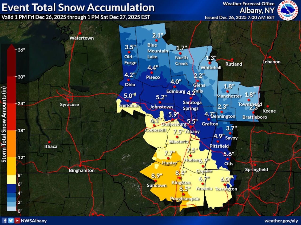 This National Weather Service graphic shows forecast snowfall amounts in eastern New York from Friday, Dec. 26, through Saturday, Dec. 27, 2025.(National Weather Service)
Generally, New York state is expected to receive between 1 and 6 inches of snow. However, AccuWeather predicts areas such as the Catskill Mountains, the northern suburbs of New York City and the northeastern corner of Pennsylvania could pick up between 6-12 inches of snow.
Areas like Syracuse, which typically takes on more snow than the city, will not be in the bullseye of this clipper, Simmers explained. In fact, the areas around Poughkeepsie look as though they will experience the worst of this snow.
The weather service foresees Poughkeepsie receiving about 8.5 inches when all is said and done.
Despite the Friday morning forecast, Simmers said that there is a “tight gradient” determining where the heaviest snowfall shall fall.
“Even a shift of like 20 miles makes a big difference in who profits and who doesn’t with the big snow given how tight the gradient is going to be with this storm,” added Simmers.
Although Simmers does not foresee a major shift in the storm’s track, he noted there could be a minor shift depending on the storm’s ultimate path and the high pressure to the north over southeast Canada.
“If any of those are out of place by, you know, 20 to 30 miles that does make a difference, especially in New York City,” Simmers explained. “If this storm goes 30 miles north that can put it (the city) more into the sleet, but if it stays, you know, 20 miles south, that can put it more into the bullseye of the snow.”
The storm should be over in the city by 8 a.m.
“Unfortunately for snow lovers, this snow is not going to be sticking around for too terribly long,” said Simmers.
Temperatures will reach into the upper 40s going into early next week and a storm on Sunday is expected to aid the melting process.