
Arctic cold remains locked-in, near-record low tonight in south-central Pennsylvania
Bitter cold continues to be the main weather story; temperatures will finally get above freezing next week
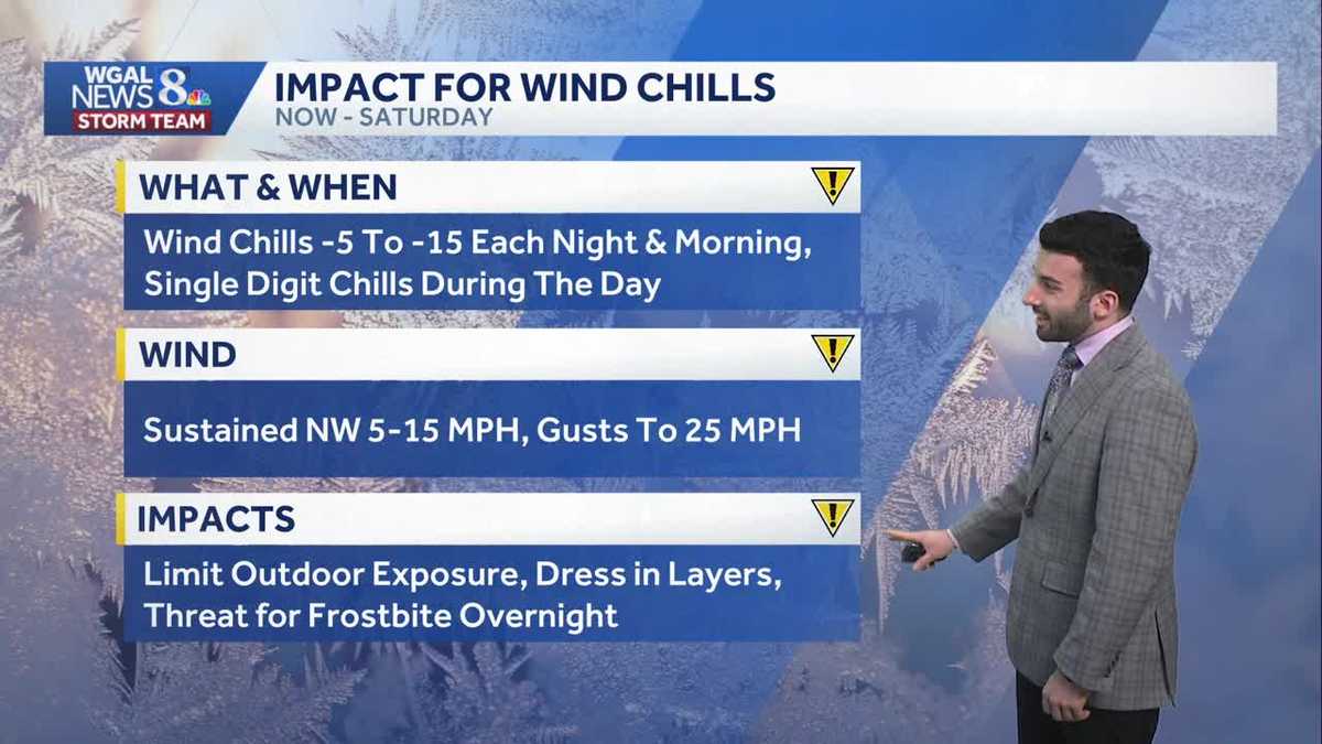
HONESTLY. ONCE A WEEK. NOW THE WGAL NEWS EIGHT STORM TEAM FORECAST WITH METEOROLOGIST RYAN ARGENTI. THE SUBZERO WIND CHILLS WILL ARE PERSISTING. SO FAR THIS ENTIRE WEEK, WE’VE HAD AN IMPACT PERIOD. SO FAR. THIS ENTIRE WORKWEEK, AND IT WILL LAST GOING UP UNTIL SATURDAY. THE ARCTIC CHILL REMAINS AND WE COULD BE CHALLENGING SOME RECORD LOWS. BY THE WAY, THAT’S THE ADDITIONAL DETAIL THAT I WANTED TO BRING OUT. BUT LOOKING AHEAD INTO THE WEEKEND, FOLKS ARE STILL ASKING, HEY, WHAT SHOULD I EXPECT FOR THE WEEKEND? WE’RE LOOKING AT DRY CONDITIONS, THE STORM THAT WE’VE BEEN TRACKING FOR THESE LAST COUPLE OF DAYS. IT WILL BE MOVING OFFSHORE, NOT EXPECTING ANY IMPACTS TO PENNSYLVANIA AT THIS TIME IN TERMS OF ANY IN TERMS OF ANY SNOWFALL. SO FOR THIS AFTERNOON, PARTLY SUNNY CONDITIONS, 20 DEGREES FOR THIS AFTERNOON. STILL GOING TO BE DEALING WITH THOSE SINGLE DIGIT CHILLS WITH THAT WITH THOSE WINDS THAT ARE PERSISTING OUT OF THE WEST NORTHWEST. AND THEN FOR THIS EVENING, CLEARING SKIES WILL BE BRISK AND FRIGID. STILL TEMPERATURES GOING DOWN TO THE LOWER TO MID TEENS RANGE. AND THEN WE DROP DOWN TO AROUND TWO DEGREES FOR TONIGHT. THIS IS THIS IS, BY THE WAY, CHALLENGING SOME POTENTIAL RECORD LOWS WHICH WE’LL COVER LATER IN THE NEWSCAST. BUT IT WILL BE MOSTLY CLEAR CHILLS DOWN TO -5 TO -15 DEGREES. IT WILL BE FEELING LIKE AND SO THAT’S ALSO THE REASON WHY THE NATIONAL WEATHER SERVICE WILL REISSUE A COLD WEATHER ADVISORY STARTING 7:00 THIS EVENING, LASTING THROUGH 10:00 IN THE MORNING ON FRIDAY. AND YOU CAN SEE FOR THE ENTIRE SUSQUEHANNA VALLEY, EVEN OUTSIDE THE SUSQUEHANNA VALLEY, TEMPERATURES INTO THE TEENS NOW IN LANCASTER, YORK, HARRISBURG, RIGHT AROUND 17 DEGREES. 18 IN CARLISLE, GETTYSBURG AND CHAMBERSBURG AT THIS TIME. BUT THAT WEST NORTHWESTERLY BREEZE, THAT’S WHAT’S MAKING IT FEEL LIKE ONE DEGREE IN LANCASTER, FEELING LIKE EIGHT DEGREES IN LEBANON, FEELING LIKE TWO DEGREES IN HARRISBURG AT THIS HOUR. AND THAT WILL PERSIST THROUGH THE REST OF THIS EVENING INTO TONIGHT, CLOSE TO FEELING LIKE ONE DEGREE CLOSER TO NINE, 11:00 TONIGHT AND THEN DOWN TOWARDS THE NEGATIVES. THE SUBZERO RANGE. ONCE WE GET INTO OVERNIGHT TONIGHT, CLOSER TO 1:00 IN THE MORNING. SO JUST SHOWING THIS ONE MORE TIME. THIS IS WHY WE HAVE IT AS IMPACT. IT’S FOR THESE WIND CHILLS. FROM NOW UNTIL SATURDAY WE’LL HAVE THESE SINGLE DIGIT CHILLS DURING THE AFTERNOON WITH SUSTAINED WINDS OUT OF THE NORTHWEST. MAKE SURE YOU’RE LIMITING OUTDOOR EXPOSURE IF YOU HAVE TO BE OUTSIDE, THEN DRESS IN LAYERS. BECAUSE IF YOU DON’T, OR IF YOU HAVE EXPOSED SKIN, YOU MIGHT HAVE THE THREAT FOR FROSTBITE TO OCCUR. NOW, STORM TEAM LIBRARY NETWORK PRECIPITATION WISE NOT SEEING ANYTHING, JUST SEEING SOME HIGH LEVEL CLOUDS THAT ARE MOVING IN, ESPECIALLY TOWARDS OUR NORTHWESTERN COMMUNITIES. BUT VERY THIN VEIL SOME CLOUDS AND THE HIGH PRESSURE THAT’S TOWARDS OUR SOUTH. THAT’S WHAT’S GOING TO HELP CLEAR OUR SKIES AND KEEP US CLEAR. HEADING INTO OUR FRIDAY AND ALSO INTO THE BEGINNING OF THE WEEKEND SLIGHTLY. BUT YOU CAN SEE THERE IS SOME HIGH CLOUDS THAT BEGIN TO DEVELOP SATURDAY MORNING. THAT’S JUST AHEAD OF THE SYSTEM. THAT’S JUST GOING TO BE MOVING OFFSHORE. SO LET’S TALK ABOUT THAT. SO I WANT TO SHOW YOU A COUPLE MODEL COMPARISONS HERE. I’M GOING TO STEP ON THIS SIDE OF THE SCREEN HERE. NOW YOU CAN SEE THE EUROPEAN MODEL IS BRINGING THE TRACK OF THIS LOW PRESSURE SYSTEM FAR OUT TO SEA AND KEEPING IT TO OUR EAST. NOW ALSO LET ME SHOW YOU THE AMERICAN MODEL, VERY SIMILAR TRACK. YOU SEE THAT THERE’S CONSISTENCY IN THE MODEL DATA, WHICH IS WHAT WE WANT TO SEE AS METEOROLOGISTS WHEN IT COMES TO GIVING YOU A FORECAST ON A SYSTEM LIKE THIS. SO BECAUSE WE’RE SEEING CONSISTENCY IN THE MODEL DATA AND THAT IT’S KEEPING THAT SNOW OFFSHORE AND AWAY FROM THE SUSQUEHANNA VALLEY, WE’RE THINKING IT WILL BE VERY UNLIKELY FOR OUR AREA TO BE RECEIVING ANY SNOWFALL, BUT STILL HAVE THAT IMPACT PERIOD, THOUGH, UP UNTIL SATURDAY. FOR THOSE WIND CHILLS. THEN WE START TO CLIMB TOWARDS THE FREEZING MARK. ONCE WE GET TO TUESDAY NEXT WEEK. MIGHT WANT TO BUST OUT THE T SHIRTS AT THIS POINT. NO, I’M JUST KIDDING. STILL CHILLY AS WE GET INTO WEDNESDA
Arctic cold remains locked-in, near-record low tonight in south-central Pennsylvania
Bitter cold continues to be the main weather story; temperatures will finally get above freezing next week

Updated: 12:36 PM EST Jan 29, 2026
Look for partly sunny skies this afternoon, then clearing skies toward evening. A brisk 5-15 mph breeze will make it feel like the single digits, although the high will reach 20 degrees. Another Cold Weather Advisory goes into effect at 7 p.m. Thursday through 10 a.m. Friday. Dress in layers, and avoid prolonged periods of time outdoors, as frostbite may develop on exposed skin.Tonight, lows will fall to 2 degrees. That would tie the record low of 2, set in 2014. The sky will be mostly clear, and a 5-10 mph breeze will produce sub-zero wind chills.Friday will feature sunshine and highs around 18 degrees. The pesky brisk breeze will still make it feel like the single digits.Another record low is in jeopardy Saturday morning. We’re expecting temperatures near 0, and the record is 2, set in 1948.The probability of a Nor’easter impacting the Susquehanna Valley remains very low this weekend, and we are not expecting snow from this system. Guidance keeps the storm offshore, but it remains close to the East Coast. We’ll continue to monitor and post updates.Temperatures will hit 18 degrees Saturday, then climb to the low 20s Sunday under partly sunny skies. Expect winds to increase Sunday, as the offshore storm moves away. Sustained winds will range from 15-25 mph, with gusts to 35 mph, keeping wind chills in the single digits most of the day.Highs will reach 30 degrees Monday under mostly sunny skies. Temperatures will finally hit the freezing mark Tuesday, and stay at or just above freezing through Friday. Although temperatures will be warmer, they’re still below average! Typical highs in early February are around 40 degrees.Aside from a chance of snow showers Friday, next week looks dry.Stay safe & warm!~ Ryan
Look for partly sunny skies this afternoon, then clearing skies toward evening. A brisk 5-15 mph breeze will make it feel like the single digits, although the high will reach 20 degrees. Another Cold Weather Advisory goes into effect at 7 p.m. Thursday through 10 a.m. Friday. Dress in layers, and avoid prolonged periods of time outdoors, as frostbite may develop on exposed skin.
Tonight, lows will fall to 2 degrees. That would tie the record low of 2, set in 2014. The sky will be mostly clear, and a 5-10 mph breeze will produce sub-zero wind chills.
Friday will feature sunshine and highs around 18 degrees. The pesky brisk breeze will still make it feel like the single digits.
Another record low is in jeopardy Saturday morning. We’re expecting temperatures near 0, and the record is 2, set in 1948.
The probability of a Nor’easter impacting the Susquehanna Valley remains very low this weekend, and we are not expecting snow from this system. Guidance keeps the storm offshore, but it remains close to the East Coast. We’ll continue to monitor and post updates.
Temperatures will hit 18 degrees Saturday, then climb to the low 20s Sunday under partly sunny skies. Expect winds to increase Sunday, as the offshore storm moves away. Sustained winds will range from 15-25 mph, with gusts to 35 mph, keeping wind chills in the single digits most of the day.
Highs will reach 30 degrees Monday under mostly sunny skies. Temperatures will finally hit the freezing mark Tuesday, and stay at or just above freezing through Friday. Although temperatures will be warmer, they’re still below average! Typical highs in early February are around 40 degrees.
Aside from a chance of snow showers Friday, next week looks dry.
Stay safe & warm!
~ Ryan