
Near-record lows are possible tonight, Arctic air persists across south-central Pennsylvania
Bitter cold continues to be the main weather story; temperatures will finally get above freezing next week
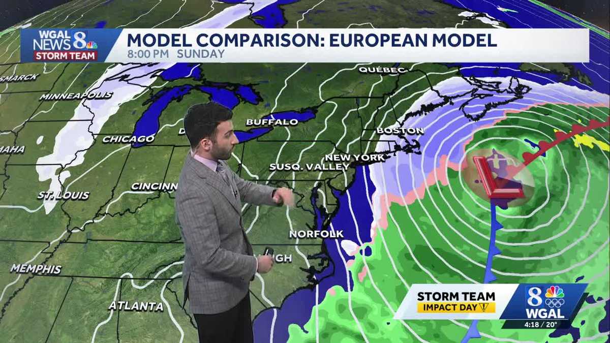
CHARGES AGAINST HIM INCLUDE BURGLARY, TRESPASSING AND EVADING ARREST. YES. SPEAKING OF WALKING ON ICE. I MEAN, I’M OUTSIDE. I’M NOT WALKING ON ANY ICE, BUT I’M JUST COLD OUT THERE, RIGHT? BECAUSE IT IS NO JOKE OUTSIDE. YEAH, AND WE’RE TALKING ABOUT IT EARLY. I MEAN, YOU HAVE TO BE CAREFUL WHEN THERE’S BLACK ICE OUT THERE BECAUSE IT’S JUST LIKE, YOU KNOW, SLIPPERY. I ALMOST TRIPPED, I’M TELLING YOU, YOU GOT TO BE CAREFUL OF SLIPPING AND ALSO JUST KEEPING YOURSELF SAFE BECAUSE IT IS COLD. WE’RE GOING SEND IT OVER TO METEOROLOGIST RYAN. ARE ARE WE GOING TO WARM UP ANYTIME SOON, OR IS THIS JUST GOING TO BE WHAT IT’S GOING TO BE? IT’S GOING TO BE WHAT IT’S GOING TO BE. THAT’S WHAT I GOT TO SAY. SORRY ABOUT THAT. BUT YOU’RE TALKING ABOUT THE DANGERS, THOUGH. I MEAN, YOU’RE GOING TO WANT TO MAKE SURE YOU’RE BUNDLING UP BECAUSE WE HAVE BELOW ZERO WIND CHILLS FOR THE NEXT FOR THE NEXT COUPLE OF DAYS. HERE WE HAVE A COLD WEATHER ADVISORY THAT WILL BE REISSUED AT 7:00 THIS EVENING, LASTING UNTIL 10:00 TOMORROW MORNING. PERSISTENT ARCTIC AIR WILL ALLOW FOR RECORD LOW TEMPERATURES, WHICH IS, BY THE WAY, ANOTHER POINT HERE IS THAT THIS HAS BEEN THE LONGEST STRETCH SO FAR IN YEARS IN TERMS OF THIS PERSISTENT COLD THAT THE SUSQUEHANNA VALLEY HAS BEEN FACING. BUT LOOKING AHEAD INTO THE WEEKEND, IT’S LOOKING DRY AND COLD. THE WINTER STORM THAT WE’VE BEEN TRACKING, THAT WE’VE BEEN TRACKING FOR THE LAST FEW DAYS NOW IS CONTINUING TO STAY OUT TO SEA. SO WE’LL CHAT ABOUT THAT HERE IN JUST A COUPLE OF MINUTES. BUT LIVE LOOK OUTSIDE OF THE RED ROSE CITY. YOU SEE SOME PUFFY CLOUDS IN THE BACKGROUND. BUT OVERALL LOOKING AT PARTLY TO MAINLY SUNNY CONDITIONS, YOU GOT 19 DEGREES IN LANCASTER WITH THAT WEST NORTHWESTERLY BREEZE, THOUGH OF ABOUT 16MPH. MAKES IT FEEL LIKE FOUR DEGREES. AND THAT’S REALLY GOING TO BE THE SAME STORY FOR THE REST OF OUR COMMUNITIES ACROSS THE VALLEY. SO WE’LL SEE. CLEARING SKIES FOR THIS EVENING. STILL LOOKING AT BRISK AND FRIGID CONDITIONS. 12 DEGREES WILL BE RIGHT AROUND WHERE WE’LL DROP DOWN AT LATER ON THIS EVENING, THEN DROPPING DOWN TO TWO DEGREES UNDER MOSTLY CLEAR CONDITIONS. CHILLS WILL BE BETWEEN NEGATIVE 5 TO -15 DEGREES. AGAIN, THAT FEELS LIKE TEMPERATURES, WHICH IS AGAIN THAT IS DANGEROUSLY LOW WHEN YOU GET TO WHEN YOU GET TO THOSE LEVELS. AND THEN TOMORROW MOSTLY SUNNY WITH SINGLE DIGIT CHILLS, 18 DEGREES FOR THE AFTERNOON. SO YOU CAN SEE OUR TEMPERATURES INTO THE 20S FOR MOST AREAS. WE’RE STILL RIGHT AROUND 19 IN LANCASTER, 16 IN LEWISTOWN. BUT WITH THAT WIND OUT OF THE WEST NORTHWEST MAKES IT FEEL LIKE THE SINGLE DIGITS ACROSS THE AREA FEELING LIKE SEVEN DEGREES IN LEBANON, EIGHT DEGREES IN CHAMBERSBURG, FIVE DEGREES IN HARRISBURG AND CARLISLE. SO DEFINITELY A VERY COLD EVENING. IT’S GOING TO BE VERY COLD FOR TONIGHT. SO COLD THAT THE NATIONAL WEATHER SERVICE WILL BE ISSUING THAT COLD WEATHER ADVISORY. LIKE I BRIEFLY MENTIONED EARLIER, FROM 7:00 THIS EVENING UNTIL 10 A.M. FRIDAY FOR THE ENTIRE SUSQUEHANNA VALLEY. AS YOU CAN SEE HIGHLIGHTED IN THAT BLUE SHADE. NOW FOR THE IMPACT FOR THE WIND CHILLS. THAT’S THAT’S WHY WE’VE BEEN IMPACT, FOLKS, FROM NOW UNTIL WE GET TO SATURDAY WITH THESE WIND CHILLS INTO THE NEGATIVES EACH NIGHT AND MORNING, IT’S DEFINITELY ALLOWS FOR FOR THE THREAT, FOR FROSTBITE TO BE AROUND WITH THIS PERSISTENT 5 TO 15 MILE PER HOUR BREEZE. SO IN TERMS OF WHAT YOU WANT TO DO, YOU CAN GO OUTSIDE, BUT YOU WANT TO LIMIT THE AMOUNT OF OUTDOOR EXPOSURE THAT YOU’RE THAT YOU’RE OUTSIDE OUTSIDE IN. YOU’RE GOING TO WANT TO MAKE SURE YOU’RE DRESSING IN LAYERS, BECAUSE ANY EXPOSED SKIN MAY BE MAY BE EXPOSED TO THE THREAT FOR SOME FROSTBITE. BUT LOOKING AT SOME MAINLY CLEAR CONDITIONS FOR THE MAJORITY OF THE AREA, THAT’S ALL THANKS TO HIGH PRESSURE THAT’S BUILDING IN FROM THE SOUTH. AND THAT’S GOING TO CONTINUE TO KEEP US CLEAR AS WE HEAD INTO THE REST OF OUR FRIDAY AND ALSO INTO INTO OUR SATURDAY. NOW SOME HIGH CLOUDS BEGIN TO MOVE IN FOR OUR SATURDAY EVENING. THAT’S ALL THANKS TO THAT COASTAL STORM THAT’S GOING TO CONTINUE TO MOVE OUT TO SEA. BY THE WAY, HERE’S THE EUROPEAN MODEL JUST SHOWING YOU WHAT WE’RE SEEING. IT’S CONTINUES TO TRACK TOWARDS OUR NORTHEAST. AND YOU CAN SEE NO SNOW FOR THE SUSQUEHANNA VALLEY. AND HERE’S THE AMERICAN MODEL. LOOKS VERY SIMILAR TO THE EUROPEAN MODEL. SO WE’RE LOOKING AT NO CHANCE VERY LITTLE TO NO CHANCE OF SOME SNOW AS WE HEAD INTO THE WEEKEND. LOOKING AHEAD INTO NEXT WEEK THOUGH, YOU CAN SEE 28 DEGREES FOR OUR MONDAY START APPROACHING THAT FREEZING MARK ONCE WE GET TO ABOUT TUESDAY. STILL NOT NOT UP TO FREEZING. FINALLY GET TO ABOUT 32 DEGREES ONCE WE GET TO OUR WEDNESDAY, AND THEN RIGHT AROUND 34 DEGREES FOR THURSDAY OF NEXT WEEK. BUT WE ARE TRACKING THE CHANCE OF POSSIBLY GUYS FOR FRIDAY, SATURDAY AND SUNDAY OF NEXT WEEK. LOOKING AT A CHANCE OF SOME SNOW SHOWERS. OH JOY, I KNOW RIGHT? I’VE NEVER BEEN SO HAPPY TO SEE THE 30S IN MY LIFE. I KNOW I WAS. I WAS JOKING EARLIER THAT MAYBE WE SHOULD START BUSTING OUT THE T SHIRTS. HEY, HEY, GET OUT, GET OUT THE FLIP FLOPS. YO
Near-record lows are possible tonight, Arctic air persists across south-central Pennsylvania
Bitter cold continues to be the main weather story; temperatures will finally get above freezing next week

Updated: 4:25 PM EST Jan 29, 2026
Look for clearing skies for this evening. A brisk 5-15 mph breeze will continue to make it feel like the single digits, despite air temperatures in the low teens! Therefore, another Cold Weather Advisory goes into effect at 7 p.m. Thursday through 10 a.m. Friday. Dress in layers, and avoid prolonged periods of time outdoors, as frostbite may develop on exposed skin.Tonight, lows will fall to 2 degrees. That would tie the record low of 2, set in 2014. The sky will be mostly clear, and a 5-10 mph breeze will produce sub-zero wind chills.Friday will feature sunshine and highs around 18 degrees. The pesky brisk breeze will still make it feel like the single digits.Another record low is in jeopardy Saturday morning. We’re expecting temperatures near 0, and the record is 2, set in 1948.The probability of a Nor’easter impacting the Susquehanna Valley remains very low this weekend, and we are not expecting snow from this system. Guidance keeps the storm offshore, but it remains close to the East Coast. We’ll continue to monitor and post updates.Temperatures will hit 18 degrees Saturday, then climb to the low 20s Sunday under partly sunny skies. Expect winds to increase Sunday, as the offshore storm moves away. Sustained winds will range from 15-25 mph, with gusts to 35 mph, keeping wind chills in the single digits most of the day.Highs will reach 30 degrees Tuesday under mostly sunny skies. Temperatures will finally hit the freezing mark Wednesday, and stay at or just above freezing through Friday. Although temperatures will be warmer, they’re still below average! Typical highs in early February are around 40 degrees.Aside from a chance of snow showers Friday, next week looks dry.Stay safe & warm!
Look for clearing skies for this evening. A brisk 5-15 mph breeze will continue to make it feel like the single digits, despite air temperatures in the low teens! Therefore, another Cold Weather Advisory goes into effect at 7 p.m. Thursday through 10 a.m. Friday. Dress in layers, and avoid prolonged periods of time outdoors, as frostbite may develop on exposed skin.
Tonight, lows will fall to 2 degrees. That would tie the record low of 2, set in 2014. The sky will be mostly clear, and a 5-10 mph breeze will produce sub-zero wind chills.
Friday will feature sunshine and highs around 18 degrees. The pesky brisk breeze will still make it feel like the single digits.
Another record low is in jeopardy Saturday morning. We’re expecting temperatures near 0, and the record is 2, set in 1948.
The probability of a Nor’easter impacting the Susquehanna Valley remains very low this weekend, and we are not expecting snow from this system. Guidance keeps the storm offshore, but it remains close to the East Coast. We’ll continue to monitor and post updates.
Temperatures will hit 18 degrees Saturday, then climb to the low 20s Sunday under partly sunny skies. Expect winds to increase Sunday, as the offshore storm moves away. Sustained winds will range from 15-25 mph, with gusts to 35 mph, keeping wind chills in the single digits most of the day.
Highs will reach 30 degrees Tuesday under mostly sunny skies. Temperatures will finally hit the freezing mark Wednesday, and stay at or just above freezing through Friday. Although temperatures will be warmer, they’re still below average! Typical highs in early February are around 40 degrees.
Aside from a chance of snow showers Friday, next week looks dry.
Stay safe & warm!