
Cold Snap Continues into the Weekend for Western PA
4 FOR THE GAME AT 330, FOLLOWED BY POSTGAME COVERAGE. AND IT IS A SEVERE WEATHER ALERT DAY FOR US TODAY. THIS IS GOING TO EXTEND INTO OUR SATURDAY AS WE’RE GOING TO GET NEAR RECORD LOW, POTENTIALLY TYING OR BREAKING TODAY AND INTO TOMORROW. IMPACT DAY FOR US ON SUNDAY. A COLD START. WE’RE STILL GOING TO BE IN THE SINGLE DIGITS, BUT THE WARM UP IS GOING TO START. WE’RE TALKING DAYTIME HIGHS IN THE UPPER TEENS, WHICH WE HAVE NOT SEEN IN A WHILE, AND THEN WE’LL EXTEND INTO THE 20S AS WE HEAD INTO NEXT WEEK. BUT LOOK AT THESE TEMPERATURES RIGHT NOW. THREE BELOW IS YOUR ACTUAL TEMPERATURE IN PITTSBURGH FOUR BELOW IN WASHINGTON TWO BELOW RIGHT NOW IN GREENSBURG, SIX BELOW CRANBERRY AND KITTANNING, 16 BELOW IN BEAVER, 14 BELOW NEWCASTLE, SEVEN BELOW IN WAYNESBURG, EVEN NINE BELOW RIGHT NOW INTO INDIANA, WINDS ARE RELATIVELY LIGHT RIGHT NOW, BUT AS WE CONTINUE THROUGH THE MORNING, WE’LL HAVE A LIGHT WIND NOT ONLY THIS MORNING, BUT THROUGH THE DAY, 5 TO 10MPH. SO IT’S STILL GOING TO KEEP OUR WIND CHILL. SINGLE DIGITS SUBZERO. THAT’S GOING TO EXTEND TONIGHT. AND EVEN AS WE HEAD INTO SATURDAY, SATURDAY MORNING I THINK WILL BE WORSE THAN WHAT WE’RE FEELING RIGHT NOW AS THOSE WIND CHILLS WILL BE ABOUT 15 TO 25 DEGREES BELOW, THEN SLOWLY STARTING TO IMPROVE AS WE GET INTO SATURDAY NIGHT AND INTO OUR SUNDAY. WE DO HAVE A COLD WEATHER ADVISORY IN PLACE FOR THE ENTIRE REGION THAT WILL EXPIRE AT 11:00, AND THEN A COLD WEATHER ADVISORY IN PLACE TONIGHT STARTING AT 7:00 AND EXTENDING UNTIL 11 A.M. ON SATURDAY. THIS IS FOR THE ENTIRE REGION AND WE ARE IN THIS COLD SNAP EXTENDING TODAY. TOMORROW, SUNDAY, START TO SEE A LITTLE BIT OF IMPROVEMENT. WE ALSO HAVE SINGLE DIGIT TEMPERATURES. EXCUSE ME EARLY MONDAY FOR GROUNDHOG DAY, BUT FINALLY GETTING OUT OF THE TEENS AND INTO THE 20S AND SLOWLY STARTING TO WARM UP, WE WILL BE WATCHING A CHANCE FOR SOME SNOW EITHER THURSDAY OR FRIDAY AT THE END OF NEXT WEEK. DOESN’T LOOK LIKE A LOT RIGHT NOW. POTENTIALLY 1 TO 2IN. WE HAVE FAIR SKIES AROUND THE REGION RIGHT NOW, A FEW HIGH CLOUDS, BUT WE ARE GOING TO SEE SOME SUNSHINE THROUGH THE DAY. WE’VE BEEN GETTING A LOT OF TALK ABOUT THIS NOR’EASTER. THE STORM SYSTEM THAT COULD POTENTIALLY IMPACT US. BUT I WILL SHOW YOU THIS IS THE LATEST AND IT DOES LOOK LIKE THIS OVER THE PAST COUPLE OF DAYS. IT’S GOING TO STAY WELL SOUTH OF US. AND NOTICE HOW IT CONTINUES TO SPIN OUT TO SEE IF ANYTHING CLIPPING PARTS OF NEW YORK AND BOSTON. BUT REALLY, WE ARE GOING TO STAY SNOW FREE WITH THAT MAJOR SNOWSTORM AS WE GET INTO OUR WEEKEND, WHICH IS SOME GOOD NEWS. THERE’S YOUR FOUR DAY PLUS FOUR FORECAST. STILL PRETTY COLD, BUT SLOWLY IMPROVING OUT OF THE NEGATIVE. STILL 0 TO 2 DEGREES SUNDAY AND MONDAY, AND EVEN OUR OVERNIGHT TEMPERATURES WILL GET BACK INTO THE TEENS AND OUR DAYTIME HIGHS
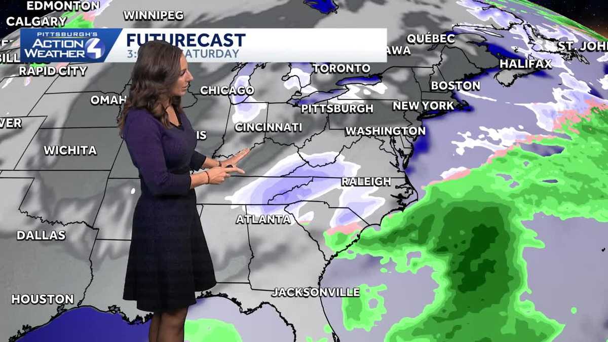
Near record low temperatures today and Saturday morning before we finally break the bitter cold.Cold Weather AdvisoryA cold weather advisory is in effect until 11 a.m. for western PA.This time, the major concern is not wind chill but the actual air temperature. As we drop toward -10°, the wind will be light, so wind chills will be close to the air temperature, but it is cold enough on its own to warrant caution if you will be outside early Friday.Alert Days: Record lows for PittsburghWe will go back to Severe Weather Alert Days for Friday and Saturday.Pittsburgh could break record low temperatures both days: both records are -5° set in 2019. Afternoon highs will only manage to reach the low-to-mid teens.The wind gets stronger Saturday morning and could plunge wind chills as cold as -25°.The cold eases slightly in early FebruaryA weekend coastal storm looks to stay far enough east that the Pittsburgh area won’t see any impacts.Temperatures will remain below freezing for early February. But instead of the teens, highs will be in the 20s. Lows will also return to the teens.We won’t see any noteworthy precipitation chances until next weekend at the earliest.TODAY – Severe Weather Alert Day: Partly cloudy and cold. High: 14°, low: -9°.SATURDAY – Severe Weather Alert Day: Record low. Mostly cloudy and frigid. High: 12°, low: 0°.SUNDAY – Impact Day: Cold start and mostly cloudy. High: 18°, low: 2°.
Near record low temperatures today and Saturday morning before we finally break the bitter cold.
Cold Weather Advisory
A cold weather advisory is in effect until 11 a.m. for western PA.
This time, the major concern is not wind chill but the actual air temperature. As we drop toward -10°, the wind will be light, so wind chills will be close to the air temperature, but it is cold enough on its own to warrant caution if you will be outside early Friday.

Alert Days: Record lows for Pittsburgh
We will go back to Severe Weather Alert Days for Friday and Saturday.
Pittsburgh could break record low temperatures both days: both records are -5° set in 2019. Afternoon highs will only manage to reach the low-to-mid teens.
The wind gets stronger Saturday morning and could plunge wind chills as cold as -25°.

The cold eases slightly in early February
A weekend coastal storm looks to stay far enough east that the Pittsburgh area won’t see any impacts.
Temperatures will remain below freezing for early February. But instead of the teens, highs will be in the 20s. Lows will also return to the teens.
We won’t see any noteworthy precipitation chances until next weekend at the earliest.

TODAY – Severe Weather Alert Day: Partly cloudy and cold. High: 14°, low: -9°.
SATURDAY – Severe Weather Alert Day: Record low. Mostly cloudy and frigid. High: 12°, low: 0°.
SUNDAY – Impact Day: Cold start and mostly cloudy. High: 18°, low: 2°.