
Pittsburgh: Record low possible again tonight
Western Pennsylvania goes under another Cold Weather Advisory overnight.
THE FAA IS, OF COURSE, NOW INVESTIGATING. IT HAS BEEN COLD FOR THE ENTIRE WEEK, BUT NOW WE ARE IN THE MIDST OF THE COLDEST AIR YET, AS WE HAVE A POLAR AIR MASS OVERHEAD, WE SET A NEW RECORD LOW TEMPERATURE THIS MORNING. WE COULD DO IT ALL OVER AGAIN TONIGHT WITH WIND CHILLS THAT COULD BE DIPPING AS LOW AS 20 TO 25 DEGREES BELOW ZERO, AND WE WILL EXTEND OUR SEVERE WEATHER ALERT DAY INTO YOUR SATURDAY AS WELL. IT LOOKS NICE. IT’S A BLUEBIRD SKY, BUT ONLY FEELS LIKE A LONELY DEGREE RIGHT NOW, SO TAKE A LIVE LOOK OVER THE ICE, OVER THREE RIVERS OF DOWNTOWN PITTSBURGH. WE WILL HANG ON TO THAT SUNSHINE, BUT STILL A BITE TO THE AIR AS WE WORK THROUGH THE FIRST OF TWO SEVERE WEATHER ALERT DAYS. WIND CHILLS THROUGH THE AFTERNOON, HOVERING CLOSE TO ZERO, IF NOT A FEW DEGREES BELOW THAT. WE WILL ONCE AGAIN SEE A COLD WEATHER ADVISORY GOING INTO EFFECT. THESE ARE FEELS LIKE TEMPERATURES WAKING UP TOMORROW MORNING AGAIN IN THAT RANGE OF ABOUT 15, EVEN 25 DEGREES BELOW ZERO. WE WILL PRAY FOR A LIGHT BREEZE, BUT EVEN WITH THAT, WE ARE STILL GOING TO SEE THAT RECORD SETTING COLD POTENTIALLY SETTLING IN AS WELL. SO AGAIN, WE COME REALLY FAMILIAR WITH THIS. EVERYBODY GOES UNDER THAT COLD WEATHER ADVISORY STARTING AT 7:00. TONIGHT TAKES US THROUGH 11 A.M. ON SATURDAY. BY THE AFTERNOON, TEMPERATURES ONLY IMPROVE TO ABOUT 12. SO VERY COLD FOR US AS WE GO THROUGH THE NEXT TWO AFTERNOONS. BACK TO BACK IMPACT DAY. AS WE HEAD INTO THE FIRST TWO DAYS OF FEBRUARY, TEMPERATURES ALSO WILL BE IMPROVING INTO NEXT WEEK. CLIMBING CLOSER TO 30 DEGREES BY THIS TIME NEXT WEEK. IT’S A SLOW PROCESS AS WE JUST SAW A GOOD AMOUNT OF BLUE SKY ON THIS VERY COLD FRIDAY AFTERNOON. ANY CLOUDS THAT TRY AND SHIFT IN LATER ON THIS EVENING, JUST GIVEN HOW COLD IT IS, WE COULD SEE A FEW STRAY FLAKES FLYING, BUT THAT’S GOING TO BE ABOUT IT. STILL LOOKING A FEW MORE CLOUDS AS WE WORK THROUGH YOUR SATURDAY. VERY SIMILAR SETUP INTO SUNDAY AS WELL. OUTSIDE THE COLD, YOUR 4-DAY PLUS 4 MORE FORECAST IS PRETTY QUIET AROUND TWO DEGREES AS YOU’RE WAKING UP EARLY TO HEAR PUNXSUTAWNEY PHIL PROGNOSTICATION MONDAY MORNING. AS WE WORK THROUGH THE UPCOMING WEEK, WE’LL SEE INTERVALS OF SUNSHINE AND CLOUDS. WE ARE GOING TO WATCH A FEW SYSTEMS THAT MAY TAKE A RUN AT US, BRINGING THE OPPORTUNITY FOR SNOW. BUT REALLY, AT THIS POINT, NO GOOD CHANCE UNTIL PROBABLY LATE NEXT WEEKEND FOR US TO SEE ANY ADDITIONAL SNOW. WE’LL JUST FOCUS ON THAT GRA
Pittsburgh: Record low possible again tonight
Western Pennsylvania goes under another Cold Weather Advisory overnight.

Updated: 2:54 PM EST Jan 30, 2026
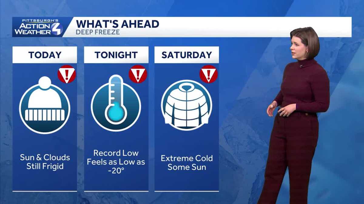
Pittsburgh set a new record low this morning. Another night of near-record lows are expected tonight. A break from the bitter cold is coming next week. Alert Day: Record lows forecast for PittsburghWe will go back to Severe Weather Alert Days for Saturday.Pittsburgh set a new record this morning and could do it again Saturday morning. Both records are -5° set in 2019. Afternoon highs will only manage to reach the low-to-mid teens.A new Cold Weather Advisory goes into effect at 7 p.m. for the entire area and continues through 11 a.m. Saturday. A quiet weekend outside of the cold airA weekend coastal storm looks to stay far enough east that the Pittsburgh area won’t see any impacts. The polar air mass remains our leading weather story. Intervals of sunshine and clouds are expected over the weekend. The cold eases slightly in early FebruarySunday and Monday are Impact Days. Temperatures will remain below freezing for early February. But instead of the teens, highs will be in the 20s. Lows will also return to the teens. We won’t see any noteworthy precipitation chances until the end of next week, at the earliest. TONIGHT – Severe Weather Alert Day: Partly cloudy, Record cold Low: -7°.SATURDAY – Severe Weather Alert Day: Partly to Mostly cloudy and frigid. High: 14°SUNDAY – Impact Day: Partly sunny. High: 19°MONDAY – Impact Day: Partly cloudy and not as cold. High: 24°
PITTSBURGH —
Pittsburgh set a new record low this morning. Another night of near-record lows are expected tonight. A break from the bitter cold is coming next week.
Alert Day: Record lows forecast for Pittsburgh
We will go back to Severe Weather Alert Days for Saturday.

Hearst OwnedHearst
Another night of record-setting cold is possible for Pittsburgh.
Pittsburgh set a new record this morning and could do it again Saturday morning. Both records are -5° set in 2019. Afternoon highs will only manage to reach the low-to-mid teens.
A new Cold Weather Advisory goes into effect at 7 p.m. for the entire area and continues through 11 a.m. Saturday.

Hearst OwnedHearst
A Cold Weather Advisory will be in effect through 11 a.m. Saturday for wind chills as low as 25 degrees below zero.
A quiet weekend outside of the cold air
A weekend coastal storm looks to stay far enough east that the Pittsburgh area won’t see any impacts. The polar air mass remains our leading weather story. Intervals of sunshine and clouds are expected over the weekend.

Hearst OwnedHearst
A quiet but still very cold set up for the weekend around western PA.
The cold eases slightly in early February
Sunday and Monday are Impact Days. Temperatures will remain below freezing for early February. But instead of the teens, highs will be in the 20s. Lows will also return to the teens. We won’t see any noteworthy precipitation chances until the end of next week, at the earliest.

Hearst OwnedHearst
Temperatures show signs of slight improvement for the early days of February.
TONIGHT – Severe Weather Alert Day: Partly cloudy, Record cold Low: -7°.
SATURDAY – Severe Weather Alert Day: Partly to Mostly cloudy and frigid. High: 14°
SUNDAY – Impact Day: Partly sunny. High: 19°
MONDAY – Impact Day: Partly cloudy and not as cold. High: 24°