
Sub-zero chills continue into the weekend, windy for Sunday for south-central Pennsylvania
Temperatures have remained well-below average, along with dangerously low wind chills these last few days. Sub-zero chills continue into Saturday, with winds increasing Sunday. We’re seeing higher temps next week along with more chances for snow.
INTO THE ICY WATER AGAIN, JUST TO MAKE SURE THERE WERE NO OTHER VICTIMS. NOW THE IMPACT DAY FORECAST FROM THE WGAL NEWS EIGHT STORM TEAM. THAT IMPACT DAY IS FOR THESE BRISK AND FRIGID WIND CHILLS THAT HAVE BEEN LASTING FOR THESE LAST SEVERAL DAYS, AND IT BECOMES DANGEROUS WHEN IT COMES TO FROSTBITE DEVELOPING, ESPECIALLY ON EXPOSED AREAS OF THE SKIN. SO STILL, WE’RE STILL EXPECTING THOSE BRISK AND FRIGID CHILLS TO PERSIST. THE STORM SYSTEM THAT WE’VE BEEN TRACKING. ALSO ANOTHER POINT TO BRING UP IS REMAINING OFFSHORE. IT’S MOVING NORTH AND EAST. SO WE’RE GOING TO BE LOOKING AT A DRY WEEKEND COMING UP FOR SATURDAY AND SUNDAY. BUT THE BELOW AVERAGE TEMPERATURES, THEY ARE CONTINUING. BUT WE ARE TRACKING MORE SNOW CHANCES FOR THE MIDDLE TO END OF NEXT WEEK. SO FOR THIS EVENING EXPECT MOSTLY CLEAR CONDITIONS STILL REMAINING FRIGID. WE’LL HAVE THAT COLD WEATHER ADVISORY THAT THAT WILL BE REISSUED AT 7:00 THIS EVENING. TEMPERATURES REMAINING RIGHT BETWEEN 6 AND 12 DEGREES FOR THE EVENING, THEN DROPPING DOWN TO RECORD CHALLENGING TEMPERATURES. BY THE WAY, THE BONE CHILLING COLD. LOOK AT THIS. FORECASTING -2 TO 2 DEGREES FOR OVERNIGHT LOW TEMPERATURES AND WIND CHILLS. GETTING DOWN TO 0 TO -15 DEGREES FOR OVERNIGHT TONIGHT. COULD SEE A FEW HIGH LEVEL CLOUDS MOVE IN. BUT OTHER THAN THAT JUST LOOKING AT SOME, JUST LOOKING AT SOME CLOUDS ROLLING, ROLLING THROUGH. AND WE’LL SEE SOME MAINLY CLEAR CONDITIONS. THEN PARTLY SUNNY CONDITIONS FOR TOMORROW AFTERNOON WITH THE SINGLE DIGIT CHILLS REMAINING BRISK AND FRIGID. STILL 18 TO 22 DEGREES FOR TOMORROW. BUT I MENTIONED IT’S RECORD CHALLENGING COLD. BY THE WAY, SATURDAY’S FORECASTED LOW IS ZERO DEGREES AND THE RECORD LOW IS TWO DEGREES, WHICH WAS SET BACK IN 1948. THAT WAS THAT WAS A WHILE AGO WHEN WE HAD THAT RECORD LOW. SO ZERO DEGREES IS WHAT WE’RE EXPECTING. SO WE’RE GOING TO BE WATCHING THESE TEMPERATURE TRENDS HEADING INTO THE OVERNIGHT PERIOD, BUT STILL GOT A FEW HOURS LEFT FOR THE PA AUTO SHOW FOR TODAY. YOU CAN SEE SUNNY CONDITIONS THEN WILL BE MOSTLY CLEAR AS WE HEAD INTO LATER THIS EVENING INTO TONIGHT, BUT STILL REMAINING BRISK AND FRIGID WITH THOSE SINGLE DIGIT CHILLS. SO MAKE SURE YOU’RE BUNDLING UP BECAUSE IT IS COLD. AND IT WAS IT IS WAS VERY COLD THIS MORNING EARLIER TODAY IN THOMASVILLE, A NEGATIVE FIVE DEGREES AS REPORTED IN YORK COUNTY AND CUMBERLAND COUNTY AND SHIPPENSBURG, NEGATIVE THREE DEGREES, NEGATIVE TWO IN WAYNESBORO AND CHESTNUT SPRINGS. AND THEN LEBANON ZERO DEGREES FROM EARLIER THIS MORNING. SO VERY COLD OUT THERE. MAKE SURE THAT YOU’RE BUNDLING UP AND HAVE A COUPLE LAYERS ON. IF YOU’RE SPENDING ANY TIME OUTDOORS. TEMPERATURES INTO THE TEENS RIGHT NOW 17 IN HARRISBURG AND CARLISLE, 16 IN LEWISTOWN. WE’RE 18 IN LEBANON AT THIS TIME, BUT STILL HAVE THAT BREEZE OUT OF THE NORTHWEST. THAT’S WHAT MAKES IT FEEL LIKE THE SINGLE DIGITS OUT THERE, MAKING IT FEEL LIKE ONE DEGREE IN LANCASTER, MAKING IT FEEL LIKE THREE DEGREES IN HARRISBURG, FEELING LIKE TWO DEGREES IN LEWISTOWN AT THIS TIME. SO HERE’S THIS COLD WEATHER ADVISORY THAT WILL GO INTO EFFECT IN THE NEXT COUPLE OF HOURS. A FEW HOURS HERE, 7 P.M. FRIDAY THROUGH 10 A.M. SATURDAY. STORM TEAM LIVE RADAR NETWORK. ALL IS QUIET. PRECIPITATION. WEISS. THANKS TO HIGH PRESSURE, IT’S HELPING TO KEEP OUR SKIES CLEAR. AND THEN ONCE WE GET INTO THE WEEKEND, SEEING SOME HIGH LEVEL CLOUDS BUILD IN. AND THAT’S ALL THANKS TO THE LOW PRESSURE SYSTEM THAT’S OFF THE SOUTHEAST COAST. AND THAT’S GOING TO CONTINUE TO TRACK ITS WAY NORTH AND EAST. WATCH THIS. WE’LL HAVE HIGH PRESSURE FROM THE WEST, BY THE WAY, CONTINUING TO PUSH THIS OUT AS THIS TRACKS NORTH AND EAST. BUT IN THE WAKE OF THIS SYSTEM ON THE BACKSIDE OF THE SYSTEM WE’LL SEE SOME CLEAR SKIES. BUT IT’S GOING TO BE GETTING WINDY ONCE WE GET INTO OUR SUNDAY. IN TERMS OF SNOWFALL EXPECTATIONS, VERY UNLIKELY FOLKS THAT WILL BE SEEING ANYTHING LOCALLY HERE IN THE SUSQUEHANNA VALLEY. SO TEN DAY FORECAST AS WE LOOK AHEAD INTO NEXT WEEK. NOT AS COLD BUT STILL COLD FOR TUESDAY. LOOK AT THIS 34 DEGREES FINALLY GETTING TO RIGHT AROUND THE FREEZING MARK FOR WEDNESDAY, WEDNESDAY THROUGH FRIDAY AND ALSO SATURDAY OF NEXT WEEK. LOOKING AT A CHANC
Sub-zero chills continue into the weekend, windy for Sunday for south-central Pennsylvania
Temperatures have remained well-below average, along with dangerously low wind chills these last few days. Sub-zero chills continue into Saturday, with winds increasing Sunday. We’re seeing higher temps next week along with more chances for snow.

Updated: 4:43 PM EST Jan 30, 2026
A rinse & repeat pattern these last several days with temperatures remaining well above average. Expect mostly sunny skies to continue this evening with frigid temps dropping to around 10 degrees. Winds between 5-15 mph breeze will contribute to wind chills feeling like the single digits to below zero across much of the Valley. Due to the prolonged cold conditions, the National Weather Service will reissue a Cold Weather Advisory that will go into 7:00 p.m. this evening through 10 a.m. Saturday, for wind chills as low as -15!A second record low is in jeopardy Saturday morning. We’re expecting temperatures near 0, and the record is 2, set in 1948. Expect clear skies and a 5-10 mph breeze, which will easily produce sub-zero wind chills.The Nor’easter we’ve been watching this week will move out to sea, away from the Susquehanna Valley this weekend. Expect partly sunny skies and highs around 20 degrees Saturday, then clearing skies and windy conditions developing Sunday, as the strong area of low pressure moves northeast. Sunday’s winds will be sustained at 15-25 mph, with gusts to 35 mph. This will keep wind chills in the single digits most of the day.Temperatures warm slightly on Monday to 30 degrees under mostly sunny skies. Tuesday’s high will finally crack the freezing mark, reaching 34 degrees.We’re watching a clipper that could bring snow showers late Wednesday into early Thursday, and another system that could bring a chance of snow showers late Friday into early Saturday. The good news is, temperatures won’t be as harsh as this past week. Expect highs around freezing, and lows in the mid-to-upper teens much of next week. Temperatures will trend colder again for the following weekend.Stay safe & warm!
A rinse & repeat pattern these last several days with temperatures remaining well above average. Expect mostly sunny skies to continue this evening with frigid temps dropping to around 10 degrees. Winds between 5-15 mph breeze will contribute to wind chills feeling like the single digits to below zero across much of the Valley. Due to the prolonged cold conditions, the National Weather Service will reissue a Cold Weather Advisory that will go into 7:00 p.m. this evening through 10 a.m. Saturday, for wind chills as low as -15!
A second record low is in jeopardy Saturday morning. We’re expecting temperatures near 0, and the record is 2, set in 1948. Expect clear skies and a 5-10 mph breeze, which will easily produce sub-zero wind chills.
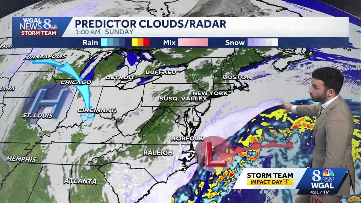
The Nor’easter we’ve been watching this week will move out to sea, away from the Susquehanna Valley this weekend. Expect partly sunny skies and highs around 20 degrees Saturday, then clearing skies and windy conditions developing Sunday, as the strong area of low pressure moves northeast. Sunday’s winds will be sustained at 15-25 mph, with gusts to 35 mph. This will keep wind chills in the single digits most of the day.
Temperatures warm slightly on Monday to 30 degrees under mostly sunny skies. Tuesday’s high will finally crack the freezing mark, reaching 34 degrees.
We’re watching a clipper that could bring snow showers late Wednesday into early Thursday, and another system that could bring a chance of snow showers late Friday into early Saturday. The good news is, temperatures won’t be as harsh as this past week. Expect highs around freezing, and lows in the mid-to-upper teens much of next week. Temperatures will trend colder again for the following weekend.
Stay safe & warm!