
Frigid Friday, dry Saturday, windy Sunday for south-central Pennsylvania
Highs will slowly climb from the teens and low 20s this weekend to the low 30s next week
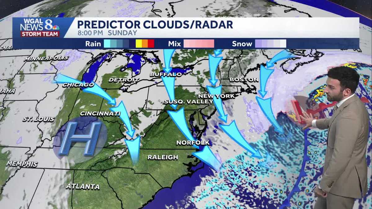
AUTO SHOW I’M GABRIEL THOMAS WGAL NEWS EIGHT. NOW THE WGAL NEWS EIGHT STORM TEAM FORECAST WITH METEOROLOGIST BRIAN ARGENTINE. AND IT’S A RINSE AND REPEAT TYPE OF FORECAST FOLKS. THESE LAST FEW DAYS WE’VE HAD SUBZERO WIND CHILLS CONTINUE FOR THESE LAST COUPLE OF DAYS. WE HAVE YET ANOTHER COLD WEATHER ADVISORY THAT WILL GO INTO EFFECT LATER THIS EVENING, 7:00 THURSDAY UNTIL 10:00 IN THE MORNING FOR YOUR FRIDAY DRY AND COLD WEEKEND. THAT WINTER STORM, BY THE WAY, IS CONTINUING TO GO OUT TO SEA AND LOOKING AHEAD INTO NEXT WEEK, WE ARE MONITORING A FEW MORE SNOW CHANCES, MORE TOWARDS THE MIDDLE TO END OF NEXT WEEK, WHICH WE’LL CHAT ABOUT IN THE TEN DAY FORECAST IN JUST A FEW MINUTES. THIS AFTERNOON THROUGH TONIGHT WILL BE 18 DEGREES. WILL TOP OUT AT STILL HAVING THOSE SINGLE DIGIT WIND CHILLS FOR THE MAJORITY OF THE DAY. MOSTLY CLEAR FOR FOR THIS EVENING. BRISK AND FRIGID, DOWN TO 12 DEGREES. WE’RE FORECASTING ZERO DEGREES FOR OVERNIGHT TONIGHT. FOLKS COULD SEE A FEW CLOUDS ROLL IN, BUT WIND CHILLS REMAINING RIGHT AROUND 0 TO -15 DEGREES DURING THE OVERNIGHT PERIOD. TEMPERATURES RIGHT NOW INTO THE INTO THE MID TEENS IN SOME AREAS. 15 DEGREES IN LEBANON, 12 DEGREES IN LANCASTER, 14 IN HARRISBURG AND CARLISLE. AND THEN FACTORING THIS WIND OUT OF THE WEST NORTHWEST, I’D SAY GENERALLY BETWEEN 10 AND 15MPH AT A STRAY 17 MILE PER HOUR BREEZE IN LEBANON. THAT MAKES IT FEEL LIKE LOOK AT THIS FEELING LIKE NEGATIVE THREE DEGREES IN LANCASTER, FEELING LIKE NEGATIVE TWO IN LEBANON. OH MAN, I’M CHILLING. JUST LIKE JUST TALKING ABOUT IT, FEELING LIKE NEGATIVE ONE IN IN HARRISBURG. SO DEFINITELY A VERY COLD DAY TODAY. AND IT’S GOING TO CONTINUE TO BE THAT WAY AS WE GET INTO THE WEEKEND. AND THAT’S ALSO WHY THE NATIONAL WEATHER SERVICE HAS, HAS WILL REISSUE A COLD WEATHER ADVISORY 7:00 THIS EVENING, LASTING UNTIL TOMORROW MORNING. SO YOU CAN SEE OVER THE NEXT 12 HOURS WE WILL BE RIGHT INTO THE SINGLE DIGITS IN GENERAL. BUT LOOK AT THIS. GOING BACK DOWN TO THE NEGATIVES IN TERMS OF THIS FEELS LIKE TEMPERATURES ONCE WE GET INTO TONIGHT. CERTAINLY GOING TO BE VERY COLD. NOW IN TERMS OF PRECIPITATION. WE HAVE BRIGHT BLUE SKIES, SEEING SOME HIGH CLOUDS BUILD IN. WE’LL SEE A FEW MORE CLOUDS LATER THIS EVENING, BUT OVERALL, THANKS TO HIGH PRESSURE, THAT’S WHAT’S ALLOWING FOR US TO HAVE SOME CLEAR SKIES. NOW GETTING INTO OUR SATURDAY. STILL LOOKING MAINLY CLEAR. SOME HIGH CLOUDS DO DEVELOP AND THAT’S ALL THANKS TO THE SYSTEM THAT’S CONTINUING TO MOVE OUT TO SEA. BUT NOTICE HIGH PRESSURE OFF TOWARDS THE WEST IS PUSHING THIS LOW PRESSURE SYSTEM OUT TO SEA. AND THOSE SNOW BANDS DON’T EVEN MAKE IT CLOSE TO THE SUSQUEHANNA VALLEY. SO THAT’S WHY WE’RE VERY CONFIDENT THAT WE’RE VERY WE’RE VERY UNLIKELY WE WON’T BE SEEING ANY SNOW. BUT THE THE MORE YOU MOVE TOWARDS THE SOUTH TOWARDS, SAY, OCEAN CITY, MARYLAND, YOU HAVE A HIGHER CHANCE OF SEEING SOME OF THOSE, THOSE HIGHER SNOW TOTALS, BUT STILL LEAVING THIS IMPACT PERIOD FOR YOUR FRIDAY AND SATURDAY FOR THE BRISKET, FRIGID CONDITIONS AND THOSE WIND CHILLS GETTING DOWN TO THE SINGLE DIGITS AND SUBZERO LEVELS, AIR TEMPERATURES REMAINING RIGHT INTO THE 20S HEADING INTO BOTH HALVES OF THE WEEKEND. WINDY AND COLD FOR YOUR GROUNDHOG DAY, BUT NOT AS COLD AS WE GET INTO TUESDAY AND WEDNESDAY. YOU CAN SEE RIGHT AROUND THAT 32 AND 34 DEGREE MARK. LOOKING AHEAD TO WEDNESDAY, THURSDAY, FRIDAY AND SATURDAY OF NEXT WEEKEND, WE ARE TRACKING SOME MORE SNOW SHOWER CHANCES, BU
Frigid Friday, dry Saturday, windy Sunday for south-central Pennsylvania
Highs will slowly climb from the teens and low 20s this weekend to the low 30s next week

Updated: 12:24 PM EST Jan 30, 2026
Expect mostly sunny skies to continue this afternoon with frigid high temps around 18 degrees. A 5-15 mph breeze will make it feel like the single digits. Another Cold Weather Advisory goes into effect at 7 p.m. Friday through 10 a.m. Saturday, for wind chills as low as -15.A second record low is in jeopardy Saturday morning. We’re expecting temperatures near 0, and the record is 2, set in 1948. Expect clear skies and a 5-10 mph breeze, which will easily produce sub-zero wind chills.The Nor’Easter we’ve been watching this week will move out to sea, away from the Susquehanna Valley this weekend. Expect partly sunny skies and highs around 20 degrees Saturday, then clearing skies and windy conditions developing Sunday, as the strong area of low pressure moves northeast. Sunday’s winds will be sustained at 15-25 mph, with gusts to 35 mph. This will keep wind chills in the single digits most of the day.Temperatures warm slightly on Monday to 30 degrees under mostly sunny skies. Tuesday’s high will finally crack the freezing mark, reaching 34 degrees.We’re watching a clipper that could bring snow showers late Wednesday into early Thursday, and another system that could bring a chance of snow showers late Friday into early Saturday. The good news is, temperatures won’t be as harsh as this past week. Expect highs around freezing, and lows in the mid-to-upper teens much of next week. Temperatures will trend colder again for the following weekend.
Expect mostly sunny skies to continue this afternoon with frigid high temps around 18 degrees. A 5-15 mph breeze will make it feel like the single digits. Another Cold Weather Advisory goes into effect at 7 p.m. Friday through 10 a.m. Saturday, for wind chills as low as -15.
A second record low is in jeopardy Saturday morning. We’re expecting temperatures near 0, and the record is 2, set in 1948. Expect clear skies and a 5-10 mph breeze, which will easily produce sub-zero wind chills.
The Nor’Easter we’ve been watching this week will move out to sea, away from the Susquehanna Valley this weekend. Expect partly sunny skies and highs around 20 degrees Saturday, then clearing skies and windy conditions developing Sunday, as the strong area of low pressure moves northeast. Sunday’s winds will be sustained at 15-25 mph, with gusts to 35 mph. This will keep wind chills in the single digits most of the day.
Temperatures warm slightly on Monday to 30 degrees under mostly sunny skies. Tuesday’s high will finally crack the freezing mark, reaching 34 degrees.
We’re watching a clipper that could bring snow showers late Wednesday into early Thursday, and another system that could bring a chance of snow showers late Friday into early Saturday. The good news is, temperatures won’t be as harsh as this past week. Expect highs around freezing, and lows in the mid-to-upper teens much of next week. Temperatures will trend colder again for the following weekend.