
Frigid chills continue through the weekend, winds increase Sunday in south-central Pennsylvania
Temps will drop through the lower teens range and winds will begin to increase out of the north. After a gusty & cold Sunday, next week will feature temps briefly at or above freezing, along with the chance of a couple snow showers.
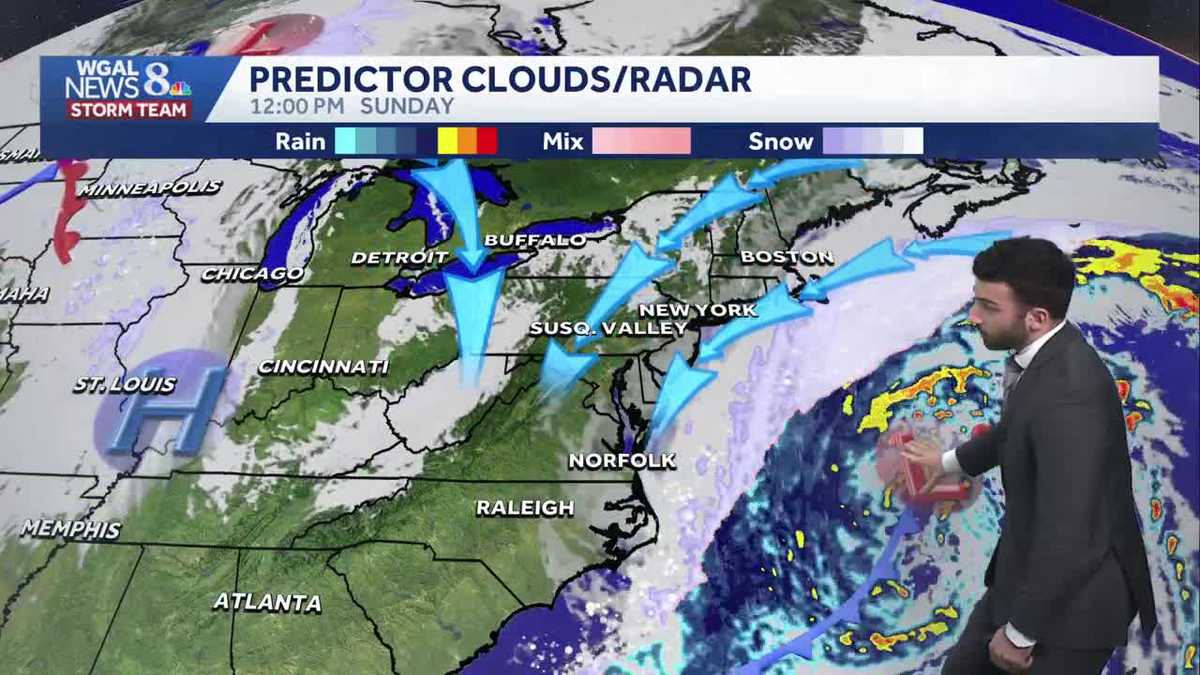
THIS YEAR’S SUPER BOWL NEXT SUNDAY, RIGHT HERE ON. NOW THE WGAL NEWS EIGHT STORM TEAM FORECAST WITH METEOROLOGIST BRIAN ARGENTE. SUBZERO CHILLS WILL CONTINUE. WE HAVEN’T YET ANOTHER COLD WEATHER ADVISORY THAT WILL BE ISSUED AT 7:00, WHICH IS IN ABOUT 45 MINUTES OR SO UNTIL ABOUT 10 A.M. SUNDAY, SO KEEP THAT IN MIND. IT WILL BE AN IMPACT PERIOD UP UNTIL ABOUT 10:00 SUNDAY. STILL WINDY AND FRIGID THOUGH FOR THE SECOND HALF OF THE WEEKEND, WINDS WILL GET UPWARDS TO ABOUT 15 TO 25MPH GUSTS GETTING UP TO POTENTIALLY 35MPH. BUT WE’LL BE WE’LL STILL BE SEEING SOME BELOW AVERAGE TEMPERATURES FOR THE MAJORITY OF THE WEEK. WE ARE WE ARE MONITORING THOUGH. HOWEVER, A FEW SNOW CHANCES, WHICH I’LL SHOW YOU IN THE TEN DAY FORECAST HERE IN JUST A COUPLE MINUTES. SO PARTLY CLOUDY, PARTLY CLOUDY CONDITIONS FOR THIS EVENING. STILL BRISK AND FRIGID. 14 DEGREES FOR AIR TEMPERATURES DROPPING DOWN TO TEN DEGREES FOR OVERNIGHT. TONIGHT. PARTLY CLOUDY. CHILLS BETWEEN 0 TO -10 DEGREES. WHEN YOU FACTOR IN, THAT BREEZE WILL START TO INCREASE IN THAT BREEZE ONCE WE GET AS WE GET INTO TONIGHT AND ALSO INTO TOMORROW, WE WILL HAVE SOME CLEARING SKIES. BUT IT’S GOING TO BE A GUSTY DAY AND STILL COLD TEMPERATURES ONLY GETTING INTO THE LOWER 20S. NOW LOOK AT THIS ALMANAC FOR THE DAY TODAY. SATURDAY 19 DEGREES. THAT WAS OUR HIGH FOR THE DAY TODAY. EARLIER. LOOK AT THIS ZERO DEGREE LOW FROM EARLIER THIS MORNING. LOOK AT THE RECORD WAS SEE THAT. SEE THAT. THAT’S RIGHT. WE BROKE A RECORD SO FAR. OR WE DID BREAK A RECORD THAT WAS SET BACK IN 1948. OLD RECORD LOW IS TWO DEGREES. IT WAS ZERO DEGREES EARLIER THIS MORNING. IT WAS ABOUT 340 IN THE MORNING. I LOOK BACK AT THE OBSERVATIONS. THAT’S WHEN WE HIT ZERO DEGREES AT HARRISBURG INTERNATIONAL AIRPORT. SO VERY COLD. WE BROKE THAT RECORD. NOW IN TERMS OF THE PA AUTO SHOW, TOMORROW IS THE LAST DAY, 10 A.M. TO 5 P.M. BUT HERE’S THE OVERALL PLANNER FOR THE DAY 16 DEGREES RIGHT AROUND 10:00. SINGLE DIGIT CHILLS REMAIN AT 24 DEGREES FOR TOMORROW AFTERNOON. BRISK AND FRIGID FOR OVERNIGHT OR FOR CLOSE TO 9:00 IN THE EVENING FOR TOMORROW. BUT HERE’S THAT COLD WEATHER ADVISORY 7 P.M. THIS EVENING UNTIL 10 A.M. SUNDAY FOR THE ENTIRE SUSQUEHANNA VALLEY. SEE. TEMPERATURES INTO THE TEENS WERE 19 IN GETTYSBURG, 18 IN CARLISLE. BUT HERE’S THAT BREEZE COMING OUT OF THE NORTH. EVEN THAT LIGHT BREEZE, FOLKS, CAN MAKE IT FEEL LIKE THE SINGLE DIGITS IN SOME COMMUNITIES. AND YOU CAN SEE IT FEELS LIKE EIGHT DEGREES IN LANCASTER AND FIVE DEGREES IN LEWISTOWN, IN CHAMBERSBURG. AND ABOUT FEELING LIKE TEN DEGREES IN HARRISBURG AND YORK AT THIS HOUR. NOW, SEEING STORM TEAM LIVE RADAR NETWORK, NO PRECIPITATION ON RADAR. ALTHOUGH LOOK AT THE CLOUDS COMING IN FROM THE SOUTH, THAT IS FROM THE COASTAL LOW PRESSURE SYSTEM THAT IS NOW THAT IS PACKING SOME SNOW TOWARDS THE CAROLINAS, TOWARDS RALEIGH ESPECIALLY. YOU SEE SOME OF THOSE HEAVIER SNOW BANDS TOWARDS THE TOWARDS THE COAST OF NORTH CAROLINA. NOW, IN TERMS OF THE TRACK OF THIS SYSTEM, HOWEVER, THAT IS GOING OUT TO SEA. NOTICE THIS. WE HAVE HIGH PRESSURE OFF TOWARDS OUR WEST. THAT’S WHAT’S GOING TO HELP PUSH THIS LOW PRESSURE SYSTEM OUT TO SEA. NOW I’M GOING TO CONTINUE TO GO FORWARD. LOOK AT THIS. STAYING AWAY FROM THE COASTLINE, NOT EXPECTING ANY SNOW. STILL HAD SOME QUESTIONS, INCLUDING FACEBOOK THAT WE’RE ASKING. HEY, ARE WE STILL SEEING SNOW FOR THIS WEEKEND? WE’RE NOT SEEING SNOW. THIS SYSTEM IS GOING OUT TO SEA. WE’LL SEE SOME HIGH PRESSURE BUILD IN. BUT IN THE WAKE OF THIS SYSTEM THOUGH, THAT ON THE BACKSIDE IT’S GOING TO GET GUSTY. WE’RE GOING TO GET A PRETTY GUSTY NORTHERLY WINDS. BUT THEN ONCE WE HAVE HIGH PRESSURE COMING IN, THAT WILL HELP TO SLIGHTLY RELAX THOSE WINDS. BUT WE’LL STILL BE A LITTLE BIT BREEZY HEADING INTO OUR MONDAY. BUT OVERALL SEEING SOME PARTLY TO MAINLY CLEAR CONDITIONS FOR THE START OF NEXT WEEK. SO NOT AS COLD THOUGH FOR YOUR TUESDAY. HITTING RIGHT AROUND 34 DEGREES. ALTHOUGH FOR THOSE WHO ARE HOPING FOR THE HIGHER TEMPERATURES OR THE WARMER WEATHER, IT’S STILL GOING TO BE COLD. WE’RE STILL BELOW AVERAGE FOR REALLY THE ENTIRETY OF THE WORKWEEK. WE ARE TRACKING A FEW SNOW SHOWERS FOR YOUR WEDNESDAY, BLUSTERY AND COLDER FO
Frigid chills continue through the weekend, winds increase Sunday in south-central Pennsylvania
Temps will drop through the lower teens range and winds will begin to increase out of the north. After a gusty & cold Sunday, next week will feature temps briefly at or above freezing, along with the chance of a couple snow showers.

Updated: 7:07 PM EST Jan 31, 2026
According to data observations, at around 3:40 a.m. last night, we hit 0°F, breaking the record of 2°F, which was set back in 1948!Partly sunny conditions will continue through the during the evening with temperatures lowering through degrees. Factor in the 5-15 mph breeze and that makes it feel like the single digits outside. Be sure to bundle up again if you’re heading out this evening. Due to how cold it has become, the National Weather Service has issued another Cold Weather Advisory from now until 10 a.m. Sunday. We will also issue another Impact Day for the very cold wind chills. Wind chills may drop as low as -15°F!The Nor’easter we’ve been watching all week will move out to sea & away from the Susquehanna Valley. However, as the strong area of low pressure moves northeast, winds will increase. Sunday’s winds will be sustained, out of the northwest 15-25, with gusts to 35 mph. Clouds early will clear during the afternoon. Highs will climb to the low to mid 20s, but it will feel like single digits.Temperatures warm slightly on Monday to 30 degrees under mostly sunny skies. Tuesday’s high will finally crack the freezing mark, reaching 34 degrees.We’re watching a clipper that could bring snow showers late Wednesday into early Thursday, and another system that could bring a chance of snow showers late Friday into early Saturday. The good news is, temperatures won’t be as harsh as this past week. Expect highs around freezing, and lows in the mid-to-upper teens much of next week. Temperatures will trend colder again for the following weekend.Have a great rest of your evening! Stay safe & warm!~ Ryan
According to data observations, at around 3:40 a.m. last night, we hit 0°F, breaking the record of 2°F, which was set back in 1948!
Partly sunny conditions will continue through the during the evening with temperatures lowering through degrees. Factor in the 5-15 mph breeze and that makes it feel like the single digits outside. Be sure to bundle up again if you’re heading out this evening. Due to how cold it has become, the National Weather Service has issued another Cold Weather Advisory from now until 10 a.m. Sunday. We will also issue another Impact Day for the very cold wind chills. Wind chills may drop as low as -15°F!
The Nor’easter we’ve been watching all week will move out to sea & away from the Susquehanna Valley. However, as the strong area of low pressure moves northeast, winds will increase. Sunday’s winds will be sustained, out of the northwest 15-25, with gusts to 35 mph. Clouds early will clear during the afternoon. Highs will climb to the low to mid 20s, but it will feel like single digits.
Temperatures warm slightly on Monday to 30 degrees under mostly sunny skies. Tuesday’s high will finally crack the freezing mark, reaching 34 degrees.
We’re watching a clipper that could bring snow showers late Wednesday into early Thursday, and another system that could bring a chance of snow showers late Friday into early Saturday. The good news is, temperatures won’t be as harsh as this past week. Expect highs around freezing, and lows in the mid-to-upper teens much of next week. Temperatures will trend colder again for the following weekend.
Have a great rest of your evening! Stay safe & warm!
~ Ryan