
Frigid wind chills continue through the weekend, winds increase Sunday in south-central Pennsylvania
Temps will bottom out in the low teens tonight and winds will begin to increase out of the north. After a gusty & cold Sunday, next week will feature temps briefly at or above freezing, along with the chance of a couple snow showers.
THIS YEAR’S SUPER BOWL NEXT SUNDAY, RIGHT HERE ON WGAL. NOW THE NEWS EIGHT STORM TEAM FORECAST WITH METEOROLOGIST BRIAN ARGENTE. THOSE SUBZERO WIND CHILLS FOLKS. THEY ARE CONTINUING FROM NOW UNTIL OUR SUNDAY. WE HAVE A COLD WEATHER ADVISORY THAT’S IN EFFECT UNTIL 10 A.M. SUNDAY FOR THE ENTIRE SUSQUEHANNA VALLEY. WE’LL CHAT ABOUT THAT HERE IN JUST A SECOND. IT’S GOING TO BE WINDY. STILL FRIGID THOUGH. LOOK AT THIS. WINDS GETTING UP TO ABOUT 15 TO 25MPH OUT OF THE NORTH NORTHEAST, WITH GUSTS UP TO 35MPH. AND THEN AS WE GET INTO NEXT WEEK, BELOW AVERAGE TEMPERATURES REMAIN. WE ARE, THOUGH WE ARE MONITORING A FEW CHANCES FOR SOME SNOW SHOWERS, WHICH WE’LL CHAT ABOUT IN THE TEN DAY FORECAST IN JUST A COUPLE OF MINUTES. SO TEN DEGREES FOR OVERNIGHT TONIGHT. WIND CHILLS GETTING DOWN INTO THE NEGATIVES FOLKS. WE’LL HAVE SOME PARTLY CLOUDY CONDITIONS AND THEN REMAIN PARTLY SUNNY FOR TOMORROW MORNING. GOING TO BE WINDY AND COLD. WE’LL HAVE WINDS ELEVATING FOR TOMORROW MORNING AROUND 14 DEGREES AND 24 FOR TOMORROW AFTERNOON, WITH CLEARING SKIES STILL GUSTY AND COLD AS WE GET INTO THE AFTERNOON. ALMANAC FOR THE DAY TODAY OR EARLIER TODAY. THE HIGH FOR THIS AFTERNOON WAS RIGHT AROUND 19 DEGREES, BUT NOTICE THIS GOT ZERO DEGREES AND YOU SEE THAT ARE SITTING RIGHT THERE. THAT IS A RECORD BROKE OKAY. WE HAVE SO LOOK AT THIS. BACK IN 1948 TWO DEGREES WAS THE RECORD LOW. NOW AS OF EARLIER THIS MORNING WE HAVE NOW BROKEN THAT RECORD. OFFICIALLY HIT ZERO DEGREES AT HARRISBURG INTERNATIONAL AIRPORT. SO A LITTLE BIT OF A FUN FACT FOR YOU THERE IN TERMS OF THE TEMPERATURES AND SOME, SOME, SOME WEATHER FUN FACTS, TEMPERATURES INTO THE INTO THE TEENS. RIGHT NOW WE’RE 14 IN HARRISBURG, 14 IN YORK, WE’RE 15 IN LEBANON, 15 IN CARLISLE AT THIS HOUR. BUT HERE COMES SOME OF THOSE WINDS. WE’RE BEGINNING TO SEE SOME OF THOSE NORTHERLY WINDS FROM THE NOR’EASTER THAT’S COMING JUST OFF THE COAST WILL BE MOVING. BY THE WAY. WE’LL SHOW YOU THAT HERE IN A SECOND. BUT WE’RE GETTING SOME OF THAT WIND INFLUENCE OR THE INFLUENCE OF SOME OF THOSE WINDS FROM THAT SYSTEM. BUT THOSE WINDS AND FACTORING THE AIR TEMPERATURES, IT MAKES IT FEEL LIKE THE SINGLE DIGITS. LOOK AT THIS FEELING LIKE THREE DEGREES IN LEBANON. HARRISBURG FEELING LIKE TWO DEGREES IN LEWISTOWN, FEELING LIKE ZERO DEGREES IN YORK. IT’S VERY COLD OUT THERE. AND THAT’S WHY WE HAVE A COLD WEATHER ADVISORY THAT’S BEEN ISSUED BY THE NATIONAL WEATHER SERVICE FOR THOSE VERY LOW WIND CHILLS, YOU CAN SEE UNTIL 10 A.M. SUNDAY MORNING. BUT JUST A FRIENDLY REMINDER TO FOLKS IS THAT WHEN YOU IF YOU ARE, IF YOU’RE OUTSIDE AND YOU’RE IN THIS IN A PROLONGED PERIOD OF BEING IN THIS COLD, AGAIN, -5 TO -15 DEGREE WIND CHILLS TONIGHT INTO OUR SUNDAY, THAT COULD ALLOW FOR FROSTBITE TO OR THE ONSET OF FROSTBITE TO OCCUR VERY QUICKLY. IT WAS ABOUT 15 MINUTES. IT COULD ACTUALLY SETTLE IN. IF YOU ARE EXPOSED TO THE OUTDOORS LIKE THIS IN THIS COLD. SO MAKE SURE YOU’RE DRESSING IN LAYERS, FOLKS, AS WE GET INTO THE THE SECOND HALF OF THE WEEKEND. NOW STORM TEAM LIVE RADAR NETWORK, JUST SEEING SOME OF THAT SATELLITE IMAGERY SHOWING THE CLOUDS BEGINNING TO MOVE IN FROM THE SOUTH. THAT’S JUST FROM THE UPPER LEVEL CLOUDS FROM THIS NOR’EASTER THAT’S MOVING OUT TO SEA, BY THE WAY, ALLOWING FOR SOME SNOW SHOWERS FOR THE CAROLINAS. BUT LOOK AT THIS. YOU CAN SEE HIGH PRESSURE BUILDING IN FROM THE WEST HELPING TO PUSH THIS SYSTEM OUT TO SEA. ALTHOUGH NOTICE THESE BLUE ARROWS, THIS NORTHERLY FLOW. IT’S GOING TO BE WINDY HEADING INTO INTO OUR SUNDAY AND ALSO INTO OUR MONDAY. BUT WITH HIGH PRESSURE BUILDING INTO THE SOUTH SHOULD HELP TO ALLOW FOR THOSE WINDS TO SUBSIDE AS WE GET INTO LATER MONDAY AND ALSO INTO OUR TUESDAY. LOOKING AHEAD THOUGH, WE DO HAVE A CHANCE OF A FEW SNOW SHOWERS FOR OUR WEDNESDAY AND THEN GETTING INTO OUR FRIDAY, WE HAVE ANOTHER CHANCE OF SOME SNOW SHOWERS. WE ARE FINE TUNING THOSE DETAILS AS WE GET CLOSER, BUT LOOK AT THOSE TEMPERATURES INTO THE 20S FOR THE BEGINNING OF THE WORKWEEK. WE’RE NOT AS COLD, BUT WE HIT RIGHT AROUND 32 DEGREES FOR TUESDAY AFTERNOON. BUT THEN WE’RE GOING BACK DOWN
Frigid wind chills continue through the weekend, winds increase Sunday in south-central Pennsylvania
Temps will bottom out in the low teens tonight and winds will begin to increase out of the north. After a gusty & cold Sunday, next week will feature temps briefly at or above freezing, along with the chance of a couple snow showers.

Updated: 11:47 PM EST Jan 31, 2026
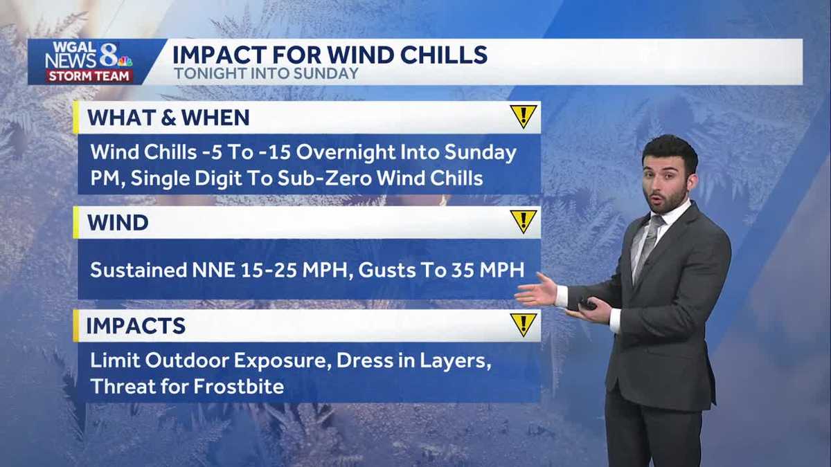
According to data observations, at around 3:40 a.m. last night, we hit 0°F, breaking the record of 2°F, which was set back in 1948!Partly cloudy conditions will continue through the overnight period with temperatures bottoming out in the low teens tonight. Factor in the increasing 5-15 mph breeze and that makes it feel like the single digits outside. Be sure to bundle up again if you’re heading out this evening. Due to how cold it has become, the National Weather Service has issued another Cold Weather Advisory from now until 10 a.m. Sunday. We will also issue another Impact Day for the very cold wind chills. Wind chills may drop as low as -15°F!The Nor’easter we’ve been watching all week will move out to sea & away from the Susquehanna Valley. However, as the strong area of low pressure moves northeast, winds will increase. Sunday’s winds will be sustained, out of the northwest 15-25, with gusts to 35 mph. Clouds early will clear during the afternoon. Highs will climb to the low to mid 20s, but it will feel like single digits.Temperatures warm slightly on Monday to 30 degrees under mostly sunny skies. Tuesday’s high will finally crack the freezing mark, reaching 34 degrees.We’re watching a clipper that could bring snow showers late Wednesday into early Thursday, and another system that could bring a chance of snow showers late Friday into early Saturday. The good news is, temperatures won’t be as harsh as this past week. Expect highs around freezing, and lows in the mid-to-upper teens much of next week. Temperatures will trend colder again for the following weekend.Have a great rest of your night! Stay safe & warm!~ Ryan
According to data observations, at around 3:40 a.m. last night, we hit 0°F, breaking the record of 2°F, which was set back in 1948!
Partly cloudy conditions will continue through the overnight period with temperatures bottoming out in the low teens tonight. Factor in the increasing 5-15 mph breeze and that makes it feel like the single digits outside. Be sure to bundle up again if you’re heading out this evening. Due to how cold it has become, the National Weather Service has issued another Cold Weather Advisory from now until 10 a.m. Sunday. We will also issue another Impact Day for the very cold wind chills. Wind chills may drop as low as -15°F!
The Nor’easter we’ve been watching all week will move out to sea & away from the Susquehanna Valley. However, as the strong area of low pressure moves northeast, winds will increase. Sunday’s winds will be sustained, out of the northwest 15-25, with gusts to 35 mph. Clouds early will clear during the afternoon. Highs will climb to the low to mid 20s, but it will feel like single digits.
Temperatures warm slightly on Monday to 30 degrees under mostly sunny skies. Tuesday’s high will finally crack the freezing mark, reaching 34 degrees.
We’re watching a clipper that could bring snow showers late Wednesday into early Thursday, and another system that could bring a chance of snow showers late Friday into early Saturday. The good news is, temperatures won’t be as harsh as this past week. Expect highs around freezing, and lows in the mid-to-upper teens much of next week. Temperatures will trend colder again for the following weekend.
Have a great rest of your night! Stay safe & warm!
~ Ryan