
Mild Tuesday; Few Evening Showers; Breezy & Cool Conditions Wednesday In South Central Pennsylvania
High temperatures will reach the upper 60s across the Susquehanna Valley on Tuesday.
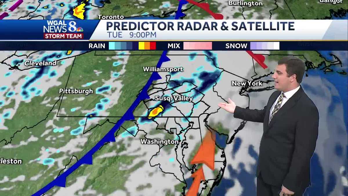
MONTHS. SCARY SITUATION, FOR SURE. UP IN ALASKA THERE WITH THAT FLOODING NOW, THANKFULLY WE WILL NOT BE GETTING THAT HERE IN THE SUSQUEHANNA VALLEY. WE IN FACT WILL HAVE MILD CONDITIONS TODAY WITH SUNSHINE THROUGHOUT THE AFTERNOON AND THEN THE CLOUDS WILL INCREASE AS WE HEAD TOWARDS THE EVENING WITH SOME SHOWER CHANCES THERE, BUT THEY’RE RATHER LIGHT BELOW AVERAGE CHILL FOR THE REST OF THE WEEK THOUGH. SO FOR THOSE OF YOU WHO LIKE FALL WEATHER OR SWEATER WEATHER, IT’S DEFINITELY GOING TO BE IN PLAY FOR THIS WEEK AND THEN UNSETTLED TOWARDS HALLOWEEN DOES LOOK LIKE OUR RAIN CHANCES INCREASE AS WE HEAD TOWARDS THE END OF THE MONTH, BUT YOUR LANCASTER, SKY CAM RIGHT NOW BASICALLY A CRYSTAL CLEAR BLUE SKY HERE THIS AFTERNOON. IT’S A NICE DAY TO MAYBE GO OUTSIDE, GRAB SOME LUNCH. IF YOU HAVE ANY YARD WORK YOU NEED TO DO, YOU CAN DO IT BECAUSE ALSO, WHILE THE WINDS ARE STILL A LITTLE BIT ON THE BREEZY SIDE HERE IN LANCASTER AND ACROSS PARTS OF THE SUSQUEHANNA VALLEY, THEY’RE NOT AS INTENSE AS THEY WERE YESTERDAY OR WILL BE TOMORROW. SO TODAY IS GOING TO BE KIND OF YOUR FIRST DAY OF THE WEEK, SO TO SPEAK, WHEN IT COMES TO THE WIND. WE’RE IN THE 60S RIGHT NOW IN LANCASTER, 60 IN LEBANON, IT’S 64, IN HARRISBURG, 66 THERE IN GETTYSBURG AND 63 IN CARLISLE, AS WELL AS PERRY COUNTY THERE FOR LANDISBURG. AS WE LOOK AT YOUR PLANNER FOR TODAY, 68 DEGREES WILL BE THE HIGH WITH INCREASING CLOUDS AHEAD OF A COLD FRONT. THAT AGAIN BRINGS US THOSE SHOWERS AS WE HEAD TOWARDS THE EVENING HOURS HERE AROUND US, FROM ANYWHERE FROM FIVE TO ABOUT 11:00 SEEMS TO BE THE TIME FRAME FOR ANY SHOWERS IN OUR AREA. DECREASING CLOUDS THOUGH WITH A FEW SHOWERS EARLY TONIGHT WITH TEMPERATURES DROPPING BACK INTO THE 40S. SO NOT AS COLD AS LAST NIGHT. TOMORROW PARTLY SUNNY. IT’S BREEZY AGAIN. GUSTS WILL BE UPWARDS OF 25, GETTING OVER 30MPH IN SOME CASES, AND COOLER HIGHS IN THE 50S. SO DEFINITELY A DAY YOU WANT TO BRING OUT THE SWEATERS HERE AS WE GO THROUGH TOMORROW. STORM TEAM LIVE RADAR SHOWING WE’VE GOT A LOT OF SUNSHINE IN PLAY, BUT ZOOMING OUT, YOU CAN SEE THAT COLD FRONT TO THE WEST. THAT’S ALSO WHERE THE CLOUDS ARE. SO AS THEY MOVE IN, WE’LL SEE THAT RAIN BEGIN TO WORK ITS WAY INTO THE SUSQUEHANNA VALLEY. BUT AS I SAID, THE TIMING FOR THIS LOOKS TO BE ANYWHERE FROM AROUND 5:00 TO ABOUT 11:00. IT’S SCATTERED IN NATURE TOO, SO YOU’RE NOT GOING TO SEE RAIN EVERYWHERE. BUT AS THAT FRONT COMES THROUGH BEHIND IT, IT’S GOING TO PICK UP WITH THE WINDS. AS WE GO INTO YOUR WEDNESDAY MORNING AND WEDNESDAY AFTERNOON. IT’S A DRY DAY. IT’S JUST GOING TO BE BREEZY AND YOU’LL SEE THE CLOUDS INCREASE IN THE AFTERNOON AS WELL AS WE GO THROUGH TOMORROW. SOME SHOWERS ENHANCED BY LAKE EFFECT OUT TO THE NORTHWEST, BUT THEY DON’T MAKE IT HERE. AS WE HEAD INTO YOUR THURSDAY, WE’LL BE SEEING SOME SUNSHINE AS WELL. TONIGHT, THE ORION METEOR SHOWER WILL PEAK IF YOU TRY TO GO OUTSIDE 10 TO 20M PER HOUR, EXPECTED BETWEEN MIDNIGHT AND DAWN. JUST MAKE SURE YOU GIVE YOURSELF ABOUT 20 MINUTES TO ADJUST TO THE DARKNESS BEING CONDITIONS ARE FAIR. WE WILL SEE DECREASING CLOUDS OVERNIGHT TONIGHT, BUT TOMORROW NIGHT PROBABLY GOING TO BE A BETTER BET HERE WITH MOSTLY CLEAR SKY ON TAP WITH THE WINDS THOUGH TOMORROW, AS I MENTIONED, THEY’RE GOING TO BE ELEVATED 20 TO 30MPH AT TIMES, MAYBE EVEN GETTING CLOSE TO 35 MILE PER HOUR. GUSTS ACROSS THE SUSQUEHANNA VALLEY HERE. SO IT’S MORNING AND AFTERNOON. SO IF YOU HAVE TRASH DAY TOMORROW, MAKE SURE YOU BRING THOSE BINS INSIDE. RAIN CHANCES, THOUGH WILL DROP THROUGH THE REST OF THE WEEK HERE AND THEN PICK BACK UP AS WE HEAD TOWARDS THE END OF THE WEEKEND INTO NEXT WEEK. AND WHEN WE LOOK AT THE 8 TO 14 DAY OUTLOOK, YOU CAN SEE THAT WE’RE RIGHT SMACK DAB IN THE MIDDLE OF THAT GREEN HERE, MEANING THAT OUR PATTERN WILL BE MORE TOWARDS ABOVE AVERAGE PRECIPITATION DURING THE END OF THE MONTH AND INTO THE BEGINNING OF NOVEMBER. SO THAT INCLUDES HALLOWEEN. AND WHEN WE LOOK AT THE TEN DAY FORECAST, YOU CAN SEE IT DOES BECOME MORE UNSETTLED TOWARDS NEXT WEEK. SO WE HAVE 68 TODAY. THEN IT WILL BE FALL-LIKE TOMORROW. BREEZY WEDNESDAY AND THURSDAY. FRIDAY LOOKING GOOD AS WELL. AND THEN AS WE HEAD TO THE WEEKEND FAIRLY DRY BEFORE THAT RAIN COMES IN. IT LOOKS LIKE FOR THE END OF NOVEMBER OR OCTOBER, EXCUSE ME AND START OF NOVEMBER. IF YOU HAVE TO STILL MAKE PLANS FOR HALLOWEEN, I WOULD SUGGEST YOU DO SOMETHING. YOU’RE GOING TO BE COVERING UP BRIAN,
Mild Tuesday; Few Evening Showers; Breezy & Cool Conditions Wednesday In South Central Pennsylvania
High temperatures will reach the upper 60s across the Susquehanna Valley on Tuesday.

Updated: 12:58 PM EDT Oct 21, 2025
Good afternoon,There is plenty of sunshine to start the day, then clouds will increase during the afternoon ahead of a cold front. Highs are milder in the mid to upper 60s. There may be a few showers in the evening and early night.In the wake of the front, temperatures drop back to the upper 50s for the rest of the week. Each day features partly sunny skies. Overnight lows will trend into the 30s & 40s, with the coldest lows late week. We are still in the growing season in many counties, so that we may be dealing with frost concerns.The weekend is looking mainly dry. Highs are uniform around 60 degrees both days. More clouds and a couple of showers are possible on Sunday. Most of the day is good to get outside.An unsettled pattern sets up as we close out October. Rain chances are likely for a couple of days with several fronts moving through the area.Have a great day!
Good afternoon,
There is plenty of sunshine to start the day, then clouds will increase during the afternoon ahead of a cold front. Highs are milder in the mid to upper 60s. There may be a few showers in the evening and early night.
In the wake of the front, temperatures drop back to the upper 50s for the rest of the week. Each day features partly sunny skies. Overnight lows will trend into the 30s & 40s, with the coldest lows late week. We are still in the growing season in many counties, so that we may be dealing with frost concerns.
The weekend is looking mainly dry. Highs are uniform around 60 degrees both days. More clouds and a couple of showers are possible on Sunday. Most of the day is good to get outside.
An unsettled pattern sets up as we close out October. Rain chances are likely for a couple of days with several fronts moving through the area.
Have a great day!